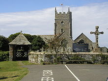
- Marhamchurch
-
Coordinates: 50°48′18″N 4°31′16″W / 50.80511°N 4.52122°W
Marhamchurch (Cornish: Eglosvarwenn) is a civil parish and village in north Cornwall, United Kingdom.
Marhamchurch village is situated 1½ miles (2 km) south of Bude off the A39 road[1].
Contents
History
The name derives from the Celtic Saint Marwenne (Morwenna) who is thought to have founded a hermitage here around the end of the fifth century. Marwenne was one of the twenty-four children of St Brychan, a Welsh saint and king.
Marhamchurch parish church is dedicated to St Marwenne. Most of the present church is of the 14th century; in the 15th century an aisle and porch were added. In the early 15th century the existence of an anchorite's cell occupied by an anchoress called Cecilia Moys is recorded.[2] Features of interest include the four-holed cresset stone and a Norman quarter-capital (though this is unlikely to be a fragment of the Norman church which may have preceded the present building). St Marwenne was probably the same as Morwenna of Morwenstow. In the 9th century the district was probably on the border between Cornwall and Wessex and the farms in the parish have Saxon names unlike those of Poundstock on the other side of the River Bude.[3]
Marhamchurch Revel
Marhamchurch Revel is a festival held every year, on the Monday after 12 August in Marhamchurch. During the festival a Queen of the Revel is chosen from the village schoolgirls and crowned by Father Time in front of the church where St. Morwenna's cells are said to have stood. Following these events a procession led by the local band and the newly crowned Revel Queen then proceeds through the village to the Revel Ground. Here the villagers are entertained with a show of Cornish dancing, Cornish Wrestling and other entertainments.
References
- ^ Ordnance Survey: Landranger map sheet 190 Bude & Clovelly ISBN 9780319231456
- ^ Charles Henderon proposed that a slab of pierced greenstone 32 in x 22 in x 4 in reused in the west wall had been the window of the cell on the north side of the chancel.
- ^ Cornish Church Guide (1925) Truro: Blackford; pp. 153-154
External links
Geography of Cornwall Cornwall Portal Unitary authorities Major settlements Bodmin • Bude • Callington • Camborne • Camelford • Falmouth • Fowey • Hayle • Helston • Launceston • Liskeard • Looe • Lostwithiel • Marazion • Newlyn • Newquay • Padstow • Par • Penryn • Penzance • Porthleven • Redruth • Saltash • St Austell • St Blazey • St Columb Major • St Ives • St Just-in-Penwith • St Mawes • Stratton • Torpoint • Truro • Wadebridge
See also: Civil parishes in CornwallRivers Topics History • Status debate • Flag • Culture • Places • People • The Duchy • Diocese • Politics • Hundreds/shires • Places of interest • full list...Civil parishes of North Cornwall constituency  Advent • Altarnun • Blisland • Bodmin • Boyton • Bude–Stratton • Camelford • Cardinham • Davidstow • Egloshayle • Egloskerry • Forrabury and Minster • Helland • Jacobstow • Kilkhampton • Laneast • Lanhydrock • Lanivet • Launceston • Launcells • Lawhitton Rural • Lesnewth • Lewannick • Lezant • Marhamchurch • Michaelstow • Morwenstow • North Hill • North Petherwin • North Tamerton • Otterham • Padstow • Poundstock • South Petherwin • St Breock • St Breward • St Clether • St Endellion • St Ervan • St Eval • St Gennys • St Issey • St Juliot • St Kew • St Mabyn • St Merryn • St Minver Highlands • St Minver Lowlands • St Stephens by Launceston Rural • St Teath • St Thomas the Apostle Rural • St Tudy • Stoke Climsland • Tintagel • Tremaine • Treneglos • Tresmeer • Trevalga • Trewen • Wadebridge • Warbstow • Week St Mary • Werrington • Whitstone • Withiel
Cornwall Portal Categories:- Villages in Cornwall
- Civil parishes in Cornwall
- Cornwall geography stubs
Wikimedia Foundation. 2010.

