- Northeast megalopolis
-
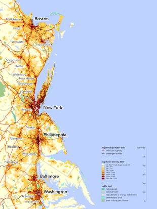 The Northeast megalopolis along the northern Atlantic coast of the United States
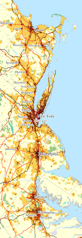
The Northeast megalopolis or Boston–Washington megalopolis is the heavily urbanized area of the United States stretching from the the northern suburbs of Boston, Massachusetts to the southern suburbs of Washington, D.C. On a map, the region appears almost as a perfectly straight line. As of 2000, the region supported 49.6 million people, about 17% of the U.S. population on less than 2% of the nation’s land area, with a population density of 931.3 people per square mile (359.6 people/km2), compared to the U.S. average of 80.5 per square mile 2[1] (31 people/km2). America 2050 projections expect the area to grow to 58.1 million people by 2025.[2][3] French geographer Jean Gottmann coined the term "megalopolis" to describe a massive urban region in his 1961 book Megalopolis: The Urbanized Northeastern Seaboard of the United States, his landmark study of the region. His conclusion was that the various cities contained in the region—especially Washington, D.C., Baltimore, Philadelphia, New York City, and Boston—are, while discrete and independent, uniquely tied to each other through the intermeshing of their suburban zones, acting in some ways as a unified super-city: a megalopolis. Since the publication of Gottmann’s book, the concept has gained prominence in both popular and academic media.
Contents
Region
The megalopolis encompasses the District of Columbia and part or all of eleven states: from south to north, Virginia, Maryland, Delaware, Pennsylvania, New Jersey, New York, Connecticut, Rhode Island, Massachusetts, New Hampshire, and Maine. It is linked by Interstate 95 and U.S. Route 1, which start in Miami and Key West, Florida, respectively, and terminate in Maine at the Canada–United States border, as well as the Northeast Corridor railway line, the busiest passenger rail line in the US. It is home to over 50 million people.[2]
The region accounts for 20% of the U.S. Gross Domestic Product.[4] The region is home to the New York Stock Exchange and NASDAQ, the White House and United States Capitol, the headquarters of the United Nations, and the headquarters of ABC, NBC, CBS, Fox, the New York Times Company, USA Today, and The Washington Post. The headquarters of many major financial companies—such as State Street, Citigroup, and Fidelity—are located within the region, which is also home to 54 of the Fortune Global 500 companies. The headquarters of 162 of the Fortune 500 are in the region.[5] The region is also the center of the global hedge fund industry, with 47.9% of $2.48 trillion of hedge fund assets being managed in its cities and suburbs.[6] Similarly, the majority of the global private equity, venture capital, investment banking, and management consulting industries are centered and/or headquartered in this region.
Academically, the region is home to six of the eight Ivy League universities (the exceptions being Dartmouth and the Cornell main campus (the medical school being in New York City)), as well as many other major universities.
Population
Combined Statistical Areas (CSAs) within the Northeast megalopolis[7]
Rank
(U.S.)Combined Statistical Area
(CSA)Census
2010Census
2000Growth
2000s1 New York-Newark-Bridgeport, NY-NJ-CT-PA CSA 22,085,649 21,361,797 +3.39% 4 Washington-Baltimore-Northern Virginia, DC-MD-VA-WV CSA 8,572,971 7,572,647 +13.21% 5 Boston-Worcester-Manchester, MA-RI-NH CSA 7,559,060 7,298,695 +3.57% 8 Philadelphia-Camden-Vineland, PA-NJ-DE-MD CSA 6,533,683 6,207,223 +5.26% History
 A satellite view of the megalopolitan region at night
The Eastern coast of the United States of America, due to its proximity to Europe, was among the first regions of the continent to be widely settled by Europeans. Over time, the cities and towns founded here had the advantage of age over most other parts of the US. However, it was the Northeast in particular that developed most rapidly, owing to a number of fortuitous circumstances.
While possessing neither particularly rich soil nor exceptional mineral wealth, the region is well-suited enough to support some levels of both agriculture and mining.[8] The climate is also temperate and not given to hurricanes or tropical storms, which was increasingly the case the further south the colonists went. However, the most important factor was the “interpenetration of land and sea,”[9] which makes for exceptional harbors, such as those at Chesapeake Bay, the Port of New York and New Jersey, the Port of Providence, and Boston Harbor. The coastline to the north is rockier and less sheltered, and to the South is smooth and does not feature as many bays and inlets that function as natural harbors. Also featured are a large number of navigable rivers that lead deeper into the heartlands. Therefore, while other parts of the country exceeded the region in raw resource value, they were not as easily accessible, and often, access to them necessarily had to pass through the Northeast first.
By 1800, there were four cities in the United States that had populations of over 25,000: Philadelphia, New York, Baltimore, and Boston, all within the region. By 1850, New York and Philadelphia alone had over 300,000 residents, while Baltimore, Boston, Cincinnati, and New Orleans had over 100,000: four were within one 400-mile strip, while the last two were each four hundred miles away from the next closest metropolis. The immense concentration of people in one relatively densely-packed area gave that region considerable sway through population density alone over the rest of the nation, which was solidified when Washington, DC, only 35 miles southwest of Baltimore, was made the capital in 1800. According to Gottmann, capital cities "will tend to create for and around the seats of power a certain kind of built environment, singularly endowed, for instance, with monumentality, stressing status and ritual, a trait that will increase with duration."[10] The transportation and telecommunications infrastructure that the capital city mandated also spilled over into the rest of the strip.
Additionally, the proximity to Europe, as well as the prominence of Ellis Island as an immigrant processing center, made New York especially but also the cities nearby a “landing wharf for European immigrants,” who represented an ever-replenished supply of diversity of thought and determined workers.[11] By contrast, the other major source of trans-oceanic immigrants was China, which was significantly farther from the US’s West Coast than Europe was from the East, and whose ethnicity made them targets of racial discrimination, creating barriers to their seamless integration into American society.
By 1950, the region held over a fifth of the total U.S. population, with a density nearly 15 times that of the national average.[12]
Concept
Jean Gottmann wrote his most famous work, Megalopolis, around the central theory that the cities between Washington, DC and Boston, MA together form a sort of cohesive, integrated “supercity.” He took the term “Megalopolis” from a small Greek town that had been settled in the Classical Era with the hopes of spanning all of Greece in a massive urban sprawl; though it still exists today, it is just a sleepy agricultural community. The dream of the founders of the original Megalopolis, Gottmann argued, was being realized in the Northeastern U.S. in the 1960s.[13]
Gottmann defined two criteria for a group of cities to be a true megalopolis: “polynuclear structure” and “manifold concentration:” that is, the presence of multiple urban nuclei, which exist independently of each other yet are integrated in a special way relative to sites outside their area.
To this end, "twin cities" such as Minneapolis–Saint Paul in Minnesota would not be considered a megalopolitan area since both cities are fairly integrated with each other even though both cities have distinct city borders and large central business districts. Large communities on the outskirts of major cities, such as Silver Spring or Bethesda in Maryland outside of Washington, DC, are clearly distinct areas with even their own downtowns. However, they are not truly independent of their host city, being still considered suburbs that would almost certainly not have developed in the ways that they have without the presence of Washington.
On the other hand, while the major cities of the Boston–Washington megalopolis all are distinct, independent cities, they are closely linked by transportation and telecommunications. Neil Gustafson showed in 1961 that the vast majority of phone calls originating in the region terminate elsewhere in the region, and it is only a minority that are routed to elsewhere in the United States or abroad.[14] Business ventures unique to the region have sprung up that capitalize on the interconnectedness of the megalopolis, such as airline shuttle services, that operate short flights between Boston-New York and New York-Washington that leave every half-hour;[15][16] and the Chinatown bus lines, which offer economy transportation between the cities’ Chinatowns and elsewhere. Other bus lines operating exclusively in the megalopolitan area owned by national or international corporations have also arisen in recent years, such as BoltBus and Megabus. The National Railroad Passenger Corporation, Amtrak, offers high-speed service only from Washington to Boston, via its Acela Express service. These ventures indicate not only the dual "independent nuclei"/"interlinked system" nature of the megalopolis, but also a broad public understanding of and capitalization on the concept.
Among examples of academic acceptance of Gottmann’s Megalopolis concept, John Rennie Short authored a major update to Gottmann’s book in 2007, Liquid City: Megalopolis and the Contemporary Northeast. The National Geographic Society released a map in 1994 of the region at the time of the Revolutionary War and in present day, which borrowed Gottmann’s book’s title and referred to him by name. Senator Claiborne Pell wrote a full-length book entitled Megalopolis Unbound in 1966, which summarized and then expanded on the original book to outline his vision for a cohesive transportation policy in the region (of which his state, Rhode Island, is part). Futurists Herman Kahn and Anthony Wiener coined the term "BosWash" in 1967 in their predictions concerning the area described by Gottmann as "Megalopolis".[17]
Use in fiction
The immensity of the megalopolis, and the idea that it might one day form an actual uninterrupted city, has inspired several authors and has resulted in extrapolations of the current megalopolis appearing in fiction. Examples include William Gibson's Sprawl trilogy, which envisions a future Boston-Atlanta Metropolitan Axis known as The Sprawl, and the even larger Quebec-Florida Mega-City One from the Judge Dredd comic book series.
See also
References
- ^ John Rennie Short, Liquid City: Megalopolis and the Contemporary Northeast, (Washington, DC, Resources for the Future, 2007), p. 23
- ^ a b http://www.america2050.org/northeast.html
- ^ Todorovich, Petra; Hagler, Yoav (January 2011). "High Speed Rail in America" (PDF). America 2050. http://www.america2050.org/pdf/HSR-in-America-Complete.pdf. Retrieved 2011-05-05.
- ^ "America 2050 Prospectus" (PDF). http://www.america2050.org/pdf/America2050prospectus.pdf. Retrieved 2010-01-11.
- ^ http://www.bafuture.org/news/railways/building-america%E2%80%99s-future-chairmen-bloomberg-and-rendell-testify-developing-high-speed
- ^ http://www.hedgefundintelligence.com/images/590/55595/Global%20hedge%20fund%20assets%20$2.48trillion.pdf
- ^ Excerpted from Table of United States Combined Statistical Areas
- ^ Jean Gottmann, Megalopolis: The Urbanized Northeastern Seaboard of the United States, (New York: The Twentieth Century Fund, 1961), 8
- ^ Gottmann, Megalopolis, p. 81-82
- ^ Jean Gottmann, Since Megalopolis: The Urban Writings of Jean Gottman, ed. Robert A. Harper, (Baltimore: The Johns Hopkins University Press, 1990) 63-64
- ^ Gottmann, Megalopolis, 45
- ^ Short, Liquid City, p. 23
- ^ Gottmann, Megalopolis, 4
- ^ Gottmann, Megalopolis, 583-593
- ^ Jeff Clabaugh, Washington Business Journal, July 18, 2002 [1]
- ^ See also Delta Shuttle, US Airways Shuttle
- ^ "Toward the year 2000: work in progress". Dædalus (Cambridge, MA: American Academy of Arts and Sciences) 96 (3): 718–719. Summer 1967. OCLC 36739595. http://books.google.com/books?id=sxb2iYN20u4C&pg=PA88. Retrieved 2009-10-24.
States Virginia • Maryland • Delaware • Pennsylvania • New Jersey • New York • Connecticut • Rhode Island • Massachusetts • New Hampshire • MainePrincipal Cities Other Major Cities over 100k Newark • Jersey City • Arlington • Yonkers • Worcester • Providence • Springfield • Alexandria • Paterson • Bridgeport • Elizabeth • Hartford • New Haven • Stamford • Manchester • Waterbury • Cambridge • LowellMajor Sub-regions New York-Newark-Bridgeport • Delaware Valley • Washington-Arlington-Alexandria • Boston-Cambridge-Quincy • Baltimore-TowsonCategories:- Megapolitan areas of the United States

Wikimedia Foundation. 2010.