- National Register of Historic Places listings in Vigo County, Indiana
-
 Location of Vigo County in Indiana
This is a list of the National Register of Historic Places listings in Vigo County, Indiana.
This is intended to be a complete list of the properties and districts on the National Register of Historic Places in Vigo County, Indiana, United States. Latitude and longitude coordinates are provided for many National Register properties and districts; these locations may be seen together in a Google map.[1]
There are 45 properties and districts listed on the National Register in the county, including 1 National Historic Landmark.
-
- This National Park Service list is complete through NPS recent listings posted November 10, 2011.[2]
Current listings
[3] Landmark name [4] Image Date listed Location City or town Summary 1 Allen Chapel African Methodist Episcopal Church 
September 5, 1975 224 Crawford St.
39°27′35″N 87°24′51″W / 39.459722°N 87.414167°WTerre Haute The African Methodist congregation in Terre Haute began meeting in 1837. The original structure was part of the Underground Railroad. The Chapel and its school have been noteworthy in the African American culture of the region. 2 Bethany Congregational Church 
September 28, 2003 201 W. Miller Ave.
39°28′01″N 87°26′45″W / 39.466944°N 87.445833°WWest Terre Haute 3 Branch of State Bank of Indiana (Memorial Hall) 
October 25, 1973 219 Ohio St.
39°27′55″N 87°24′52″W / 39.465278°N 87.414583°WTerre Haute 4 Building at 23-27 S. Sixth Street 
June 30, 1983 23-27 S. 6th St.
39°27′57″N 87°24′36″W / 39.465833°N 87.41°WTerre Haute 5 Building at 510-516 Ohio Street 
June 30, 1983 510-516 Ohio St.
39°27′57″N 87°24′39″W / 39.465833°N 87.410833°WTerre Haute 6 Building at 810 Wabash Avenue 
June 30, 1983 810 Wabash Ave.
39°28′00″N 87°24′19″W / 39.466667°N 87.405278°WTerre Haute 7 Butternut Hill 
May 27, 1993 4430 Wabash Ave.
39°28′33″N 87°21′07″W / 39.475833°N 87.351944°WTerre Haute 8 Carr's Hall 
June 30, 1983 329-333 Walnut St.
39°27′52″N 87°24′46″W / 39.464444°N 87.412778°WTerre Haute 9 Chamber of Commerce Building 
June 30, 1983 627 Cherry St.
39°28′02″N 87°24′31″W / 39.467222°N 87.408611°WTerre Haute 10 Citizens' Trust Company Building 
June 30, 1983 19-21 S. 6th St.
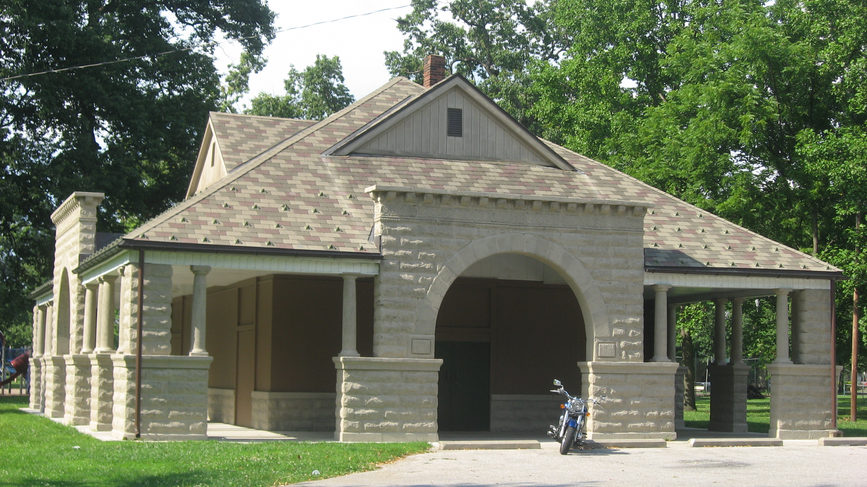
39°27′58″N 87°24′36″W / 39.466111°N 87.41°WTerre Haute 11 Collett Park 
December 10, 1981 N. 7th St. and Maple Ave.
39°29′38″N 87°24′21″W / 39.493889°N 87.405833°WTerre Haute A city park established in 1883 on land donated by railroad entrepreneur Josephus Collett. 21 acres (85,000 m2) in size, the tree-filled park included a pavilion built in 1894 by J. Merrill Sherman. 12 Collett Park Neighborhood Historic District 
March 22, 2004 Roughly bounded by 7th St., Maple Ave., 11th St., and Florida Ave.
39°29′44″N 87°24′18″W / 39.495556°N 87.405°WTerre Haute A residential neighborhood surrounding Collett Park, the district is known for its homes, many built between 1900 and 1920. Architectural styles include Queen Anne Style, Shingle Style and Colonial Revival. 13 Condit House 
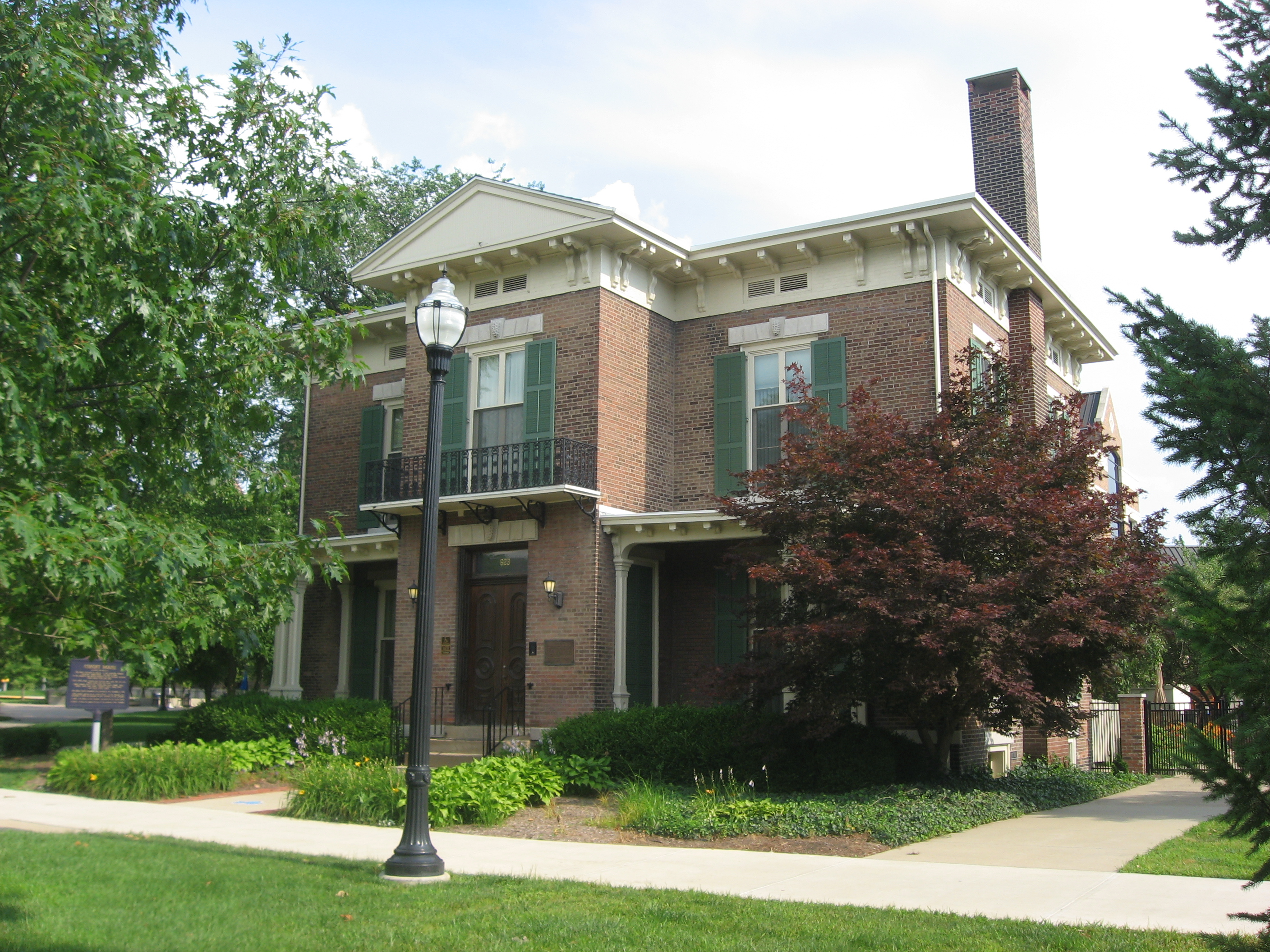
April 2, 1973 629 Mulberry St. on the Indiana State University campus
39°28′06″N 87°24′32″W / 39.468333°N 87.408889°WTerre Haute Official residence of the President of Indiana State University; built in 1860 and bequeathed to the University in 1962. Oldest building on the campus. 14 Eugene V. Debs House 
November 13, 1966 451 N. 8th St.
39°28′18″N 87°24′20″W / 39.471667°N 87.405556°WTerre Haute This house was built in 1890 by Eugene V. Debs and his wife Kate. The building, within the campus of Indiana State University, is now a museum commemorating Debs' life. 15 Paul Dresser Birthplace 
January 22, 1973 1st and Farrington Sts.
39°27′24″N 87°25′02″W / 39.456667°N 87.417222°WTerre Haute The birthplace and family home of composer Paul Dresser, this structure was originally at a different location in the town. When threatened by urban renewal in the 1960s, the home was moved to its current location in Fairbanks Park near the Wabash River. 16 Farrington's Grove Historic District 
February 27, 1986 Roughly bounded by Poplar, S. 7th, Hulman, and S. 4th Sts.
39°27′22″N 87°24′35″W / 39.456111°N 87.409722°WTerre Haute 17 Fire Station No. 9 
December 16, 1982 1728 S. 8th St.
39°26′51″N 87°24′19″W / 39.4475°N 87.405278°WTerre Haute 18 First Congregational Church 
June 30, 1983 630 Ohio St.
39°27′57″N 87°24′33″W / 39.465833°N 87.409167°WTerre Haute 19 First National Bank 
May 7, 1992 509 Wabash Ave.
39°27′59″N 87°24′39″W / 39.466389°N 87.410833°WTerre Haute 20 Foley Hall 
March 21, 1985 Saint Mary-of-the-Woods College campus, off U.S. Route 150
39°30′38″N 87°27′44″W / 39.510556°N 87.462222°WSt. Mary's 21 Greenwood Elementary School 
September 26, 1997 145 E. Voorhees Ave.
39°26′26″N 87°24′56″W / 39.440556°N 87.415556°WTerre Haute 22 Highland Lawn Cemetery 
November 29, 1990 4520 Wabash Ave.
39°28′45″N 87°20′46″W / 39.479167°N 87.346111°WTerre Haute Opened in 1884, the cemetery features Richardsonian Romanesque landscaping and architecture from the late 19th century. Famous interments include Eugene V. Debs, Max Ehrmann, and Valeska Suratt. 23 Hippodrome Theatre 
June 30, 1983 727 Ohio St.
39°27′55″N 87°24′21″W / 39.465278°N 87.405833°WTerre Haute The Hippodrome was designed by noted theater architect John Eberson. The German Renaissance structure opened in 1915 and became a spot for opera, theater, and vaudeville. The building is currently owned by the Scottish Rite. 24 House at 209-211 S. Ninth Street 
June 30, 1983 209-211 S. 9th St.
39°27′50″N 87°24′16″W / 39.463889°N 87.404444°WTerre Haute 25 House at 823 Ohio Street 
June 30, 1983 823 Ohio St.
39°27′55″N 87°24′18″W / 39.465278°N 87.405°WTerre Haute 26 Indiana Theatre 
November 13, 1997 683 Ohio St.
39°27′55″N 87°24′26″W / 39.465278°N 87.407222°WTerre Haute 27 Linton Township High School and Community Building 
March 20, 2002 13041 Pimento Circle
39°18′30″N 87°23′06″W / 39.308397°N 87.385083°WPimento 28 Markle House and Mill Site 
September 10, 1979 4900 Mill Dam Rd.
39°31′38″N 87°20′48″W / 39.527222°N 87.346667°WNorth Terre Haute 29 Ohio Boulevard-Deming Park Historic District 
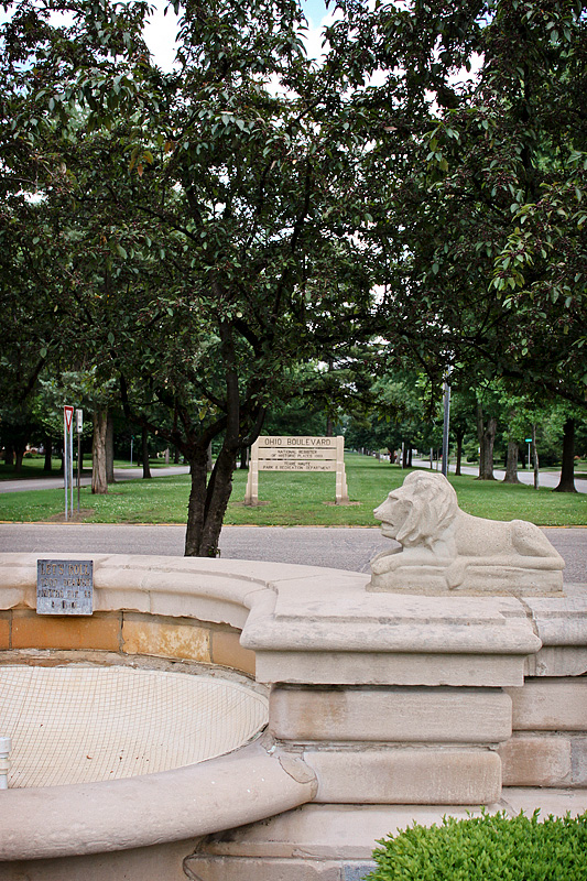
September 14, 1989 Roughly Ohio Boulevard from 19th to Keane
39°27′57″N 87°21′39″W / 39.465833°N 87.360833°WTerre Haute Designed by architect and city planner George E. Kessler and developed by landowner Demas Deming, Jr, the boulevard is 1.5 miles (2.4 km) lined with trees and homes, with a median maintained as city park land. 30 Sage-Robinson-Nagel House 
April 11, 1973 1411 S. 6th St.
39°27′07″N 87°24′36″W / 39.451944°N 87.41°WTerre Haute 31 Frank Senour Round Barn 
April 2, 1993 6400 E. Oregon Church Rd.
39°20′07″N 87°19′10″W / 39.335278°N 87.319444°WBlackhawk Built in 1905 in the heyday of round barn construction, it is a true round barn with no angles in its circumference and a conical roof. Part of a multiple listing of historic Indiana barns. 32 Star Building 
June 30, 1983 601-603 Ohio St.
39°27′55″N 87°24′35″W / 39.465278°N 87.409722°WTerre Haute 33 State Normal Library 
June 27, 2002 626 Eagle St.
39°28′11″N 87°24′30″W / 39.469722°N 87.408333°WTerre Haute 34 Terminal Arcade 
June 30, 1983 822 Wabash Ave.
39°28′00″N 87°24′17″W / 39.466667°N 87.404722°WTerre Haute This beaux-arts structure was designed by Daniel H. Burnham and was originally an interurban train station. Made of terra cotta and brick, it has identical facades on the north and south sides. Currently the building is a bar restaurant. 35 Terre Haute Fire Station No. 8 
June 15, 2000 1831 Wabash Ave.
39°28′08″N 87°23′19″W / 39.468889°N 87.388611°WTerre Haute 36 Terre Haute Masonic Temple 
June 9, 1995 224 N. 8th St.
39°28′09″N 87°24′22″W / 39.469167°N 87.406111°WTerre Haute 37 Terre Haute Post Office and Federal Building 
August 13, 1984 7th and Cherry Sts.
39°28′02″N 87°24′27″W / 39.467222°N 87.4075°WTerre Haute 38 Twelve Points Historic District 
April 20, 2005 Lafayette Ave. from Linden to 13th St. and Maple Ave. from Garfield to 13th St.
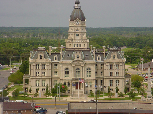
39°29′31″N 87°23′56″W / 39.491944°N 87.398889°WTerre Haute 39 Vigo County Courthouse 
June 30, 1983 Courthouse Sq.
39°27′57″N 87°24′52″W / 39.465833°N 87.414444°WTerre Haute Designed by architect Samuel Hannaford in the Second Empire style, the courthouse was dedicated in 1883 and is the seat of government in Vigo County. Features a two-ton bell partially funded by money left in the will of Colonel Francis Vigo. 40 Vigo County Home for Dependent Children 
June 15, 2000 7140 Wabash Ave.
39°29′16″N 87°18′21″W / 39.487778°N 87.305833°WTerre Haute 41 Wabash Avenue-East Historic District 
June 30, 1983 Wabash Ave. and 7th and 8th Sts.; also 26-34 8th St.; also roughly bounded by 6th, Ohio, 7th, and Walnut Sts.
39°27′59″N 87°24′24″W / 39.466389°N 87.406667°WTerre Haute Second and third sets of boundaries represent boundary increases of April 9, 1992 and August 9, 2006 respectively 42 Wabash Avenue-West Historic District 
June 30, 1983 Wabash Ave. and 6th St.
39°28′00″N 87°24′39″W / 39.466667°N 87.410833°WTerre Haute 43 Booker T. Washington School 
October 16, 2002 1201 S. 13th St.
39°27′15″N 87°23′53″W / 39.454167°N 87.398056°WTerre Haute 44 Williams-Warren-Zimmerman House 
October 23, 1980 900-904 S. 4th St.
39°27′27″N 87°24′44″W / 39.4575°N 87.412222°WTerre Haute 45 Woodrow Wilson Junior High School 
March 25, 1996 301 S. 25th St.
39°27′50″N 87°22′48″W / 39.463889°N 87.38°WTerre Haute See also
- List of National Historic Landmarks in Indiana
- National Register of Historic Places listings in Indiana
References
- ^ The latitude and longitude information provided in this table was derived originally from the National Register Information System, which has been found to be fairly accurate for about 99% of listings. For about 1% of NRIS original coordinates, experience has shown that one or both coordinates are typos or otherwise extremely far off; some corrections may have been made. A more subtle problem causes many locations to be off by up to 150 yards, depending on location in the country: most NRIS coordinates were derived from tracing out latitude and longitudes off of USGS topographical quadrant maps created under the North American Datum of 1927, which differs from the current, highly accurate WGS84 GPS system used by Google maps. Chicago is about right, but NRIS longitudes in Washington are higher by about 4.5 seconds, and are lower by about 2.0 seconds in Maine. Latitudes differ by about 1.0 second in Florida. Some locations in this table may have been corrected to current GPS standards.
- ^ "National Register of Historic Places: Weekly List Actions". National Park Service, United States Department of the Interior. Retrieved on November 10, 2011.
- ^ Numbers represent an ordering by significant words. Various colorings, defined here, differentiate National Historic Landmark sites and National Register of Historic Places Districts from other NRHP buildings, structures, sites or objects.
- ^ "National Register Information System". National Register of Historic Places. National Park Service. . http://nrhp.focus.nps.gov/natreg/docs/All_Data.html.
U.S. National Register of Historic Places Topics Lists by states Alabama • Alaska • Arizona • Arkansas • California • Colorado • Connecticut • Delaware • Florida • Georgia • Hawaii • Idaho • Illinois • Indiana • Iowa • Kansas • Kentucky • Louisiana • Maine • Maryland • Massachusetts • Michigan • Minnesota • Mississippi • Missouri • Montana • Nebraska • Nevada • New Hampshire • New Jersey • New Mexico • New York • North Carolina • North Dakota • Ohio • Oklahoma • Oregon • Pennsylvania • Rhode Island • South Carolina • South Dakota • Tennessee • Texas • Utah • Vermont • Virginia • Washington • West Virginia • Wisconsin • WyomingLists by territories Lists by associated states Other Municipalities and communities of Vigo County, Indiana City 
Towns Townships Fayette | Harrison | Honey Creek | Linton | Lost Creek | Nevins | Otter Creek | Pierson | Prairie Creek | Prairieton | Riley | Sugar Creek
Unincorporated
communitiesAllendale | Atherton | Barnhart Town | Blackhawk | Brown Jug Corner | Burnett | Cherryvale | Coal Bluff | Cobb | Deming Woods | Dewey | Duane Yards | East Glenn | Ehrmandale | Ferguson Hill | Fontanet | Glenn Ayr | Gospel Grove | Grange Corner | Harrison | Hickory Island | Hutton | Keller | Larimer Hill | Lewis | Libertyville | Liggett | Marion Heights | Markles | New Goshen | North Terre Haute | Otter Creek Junction | Parkview | Pimento | Pine Ridge | Prairie Creek | Prairieton | Preston | Saint Mary-of-the-Woods | Sandcut | Sandford | Shepardsville | Shirkieville | Southwood | Spelterville | Spring Hill | State Line | Swalls | Tabertown | Taylorville | Tecumseh | Terre Town | Toad Hop | Twelve Points | Vigo | Whitcomb Heights | Woodgate | Youngstown
Categories:- National Register of Historic Places in Indiana by county
- National Register of Historic Places in Vigo County, Indiana
-


Wikimedia Foundation. 2010.