- National Register of Historic Places listings in Knox County, Indiana
-
 Location of Knox County in Indiana
This is a list of the National Register of Historic Places listings in Knox County, Indiana.
This is intended to be a complete list of the properties and districts on the National Register of Historic Places in Knox County, Indiana, United States. Latitude and longitude coordinates are provided for many National Register properties and districts; these locations may be seen together in a Google map.[1]
There are 17 properties and districts listed on the National Register in the county, including 1 National Historic Landmark.
-
- This National Park Service list is complete through NPS recent listings posted November 10, 2011.[2]
Current listings
[3] Landmark name [4] Image Date listed Location City or town Summary 1 County Bridge No. 45 
September 20, 2006 Carries County Road 229 over the White River
38°40′46″N 87°16′23″W / 38.679444°N 87.273°WWheatland Extends into Daviess County 2 Enoco Coal Mine 
December 28, 2010 Northern side of Grundman Rd., 1.5 miles south of Bruceville
38°43′46″N 87°24′50″W / 38.72944°N 87.41389°W[5]Bruceville 3 Fort Knox II Site 
March 24, 1982 3 miles north of Vincennes
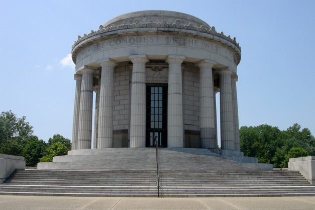
38°43′27″N 87°30′24″W / 38.72417°N 87.50667°W[6]Vincennes 4 George Rogers Clark National Historical Park 
October 15, 1966 2nd St., south of U.S. Route 50
38°40′44″N 87°32′7″W / 38.67889°N 87.53528°WVincennes 5 Hack and Simon Office Building 
March 26, 2003 1101 N. 3rd St.
38°41′04″N 87°31′14″W / 38.684444°N 87.520694°WVincennes 6 William Henry Harrison Home 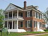
October 15, 1966 3 W. Scott St.
38°41′08″N 87°31′34″W / 38.685556°N 87.526111°WVincennes 7 Kixmiller's Store 
December 8, 1978 Carlise and Indianapolis Sts.
38°51′54″N 87°18′21″W / 38.865°N 87.305833°WFreelandville 8 Andrew Nicholson Farmstead June 17, 2005 12095 E. State Road 550
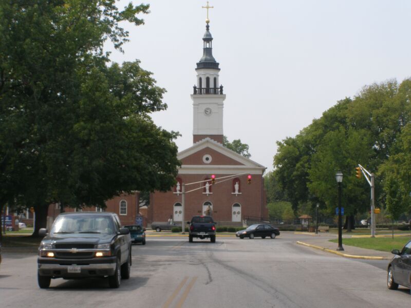
38°40′08″N 87°19′00″W / 38.668889°N 87.316667°WWheatland 9 Old Cathedral Complex 
August 17, 1976 205 Church St.
38°40′44″N 87°32′03″W / 38.678889°N 87.534167°WVincennes 10 Old State Bank 
October 9, 1974 N. 2nd St.
38°40′50″N 87°31′52″W / 38.680667°N 87.531111°WVincennes 11 Pyramid Mound (12k14) 
May 12, 1975 Southern side of Wabash Avenue, southeast of central Vincennes
38°40′14″N 87°30′22″W / 38.67056°N 87.50611°W[7]Vincennes Also known as "Lower Sugarloaf Mound"[8] 12 Rose Hill Farmstead 
March 3, 1995 Old Louisville Rd, 0.25 miles north of its junction with Old Wheatland Rd.
38°42′01″N 87°25′11″W / 38.700278°N 87.419722°WVincennes 13 Shadowwood 
June 6, 2001 6451 E. Wheatland Rd.
38°41′59″N 87°25′06″W / 38.699722°N 87.418333°WVincennes 14 Alfred Simonson House 
December 24, 2009 207 Shipping St.
38°48′43″N 87°14′55″W / 38.811806°N 87.248667°WEdwardsport 15 Territorial Capitol of Former Indiana Territory 
July 2, 1973 Bounded by Harrison, 1st, Scott, and Park Sts.
38°41′07″N 87°31′31″W / 38.685389°N 87.525167°WVincennes 16 Vincennes Fortnightly Club 
September 22, 2000 421 N. 6th St.
38°40′45″N 87°31′31″W / 38.679167°N 87.525278°WVincennes 17 Vincennes Historic District 
December 31, 1974 Vincennes
38°40′41″N 87°31′43″W / 38.678056°N 87.528611°WVincennes See also
- List of National Historic Landmarks in Indiana
- National Register of Historic Places listings in Indiana
References
- ^ The latitude and longitude information provided in this table was derived originally from the National Register Information System, which has been found to be fairly accurate for about 99% of listings. For about 1% of NRIS original coordinates, experience has shown that one or both coordinates are typos or otherwise extremely far off; some corrections may have been made. A more subtle problem causes many locations to be off by up to 150 yards, depending on location in the country: most NRIS coordinates were derived from tracing out latitude and longitudes off of USGS topographical quadrant maps created under North American Datum of 1927, which differs from the current, highly accurate GPS system used by Google maps. Chicago is about right, but NRIS longitudes in Washington are higher by about 4.5 seconds, and are lower by about 2.0 seconds in Maine. Latitudes differ by about 1.0 second in Florida. Some locations in this table may have been corrected to current GPS standards.
- ^ "National Register of Historic Places: Weekly List Actions". National Park Service, United States Department of the Interior. Retrieved on November 10, 2011.
- ^ Numbers represent an ordering by significant words. Various colorings, defined here, differentiate National Historic Landmark sites and National Register of Historic Places Districts from other NRHP buildings, structures, sites or objects.
- ^ "National Register Information System". National Register of Historic Places. National Park Service. . http://nrhp.focus.nps.gov/natreg/docs/All_Data.html.
- ^ Geocode coordinates derived from NRHP nomination form
- ^ Address derived from this Vincennes Convention and Visitors' Bureau webpage; coordinates derived from its GNIS feature record. The NRIS lists the site as "Address Restricted".
- ^ Wabash Avenue location derived from this Vincennes Convention and Visitors' Bureau webpage; location and coordinates derived from the GNIS feature record for the "Indian Mound" along Wabash Avenue. The NRIS lists the site as "Address Restricted"
- ^ Attractions, City of Vincennes, 2003. Accessed 2009-09-11.
U.S. National Register of Historic Places Topics Lists by states Alabama • Alaska • Arizona • Arkansas • California • Colorado • Connecticut • Delaware • Florida • Georgia • Hawaii • Idaho • Illinois • Indiana • Iowa • Kansas • Kentucky • Louisiana • Maine • Maryland • Massachusetts • Michigan • Minnesota • Mississippi • Missouri • Montana • Nebraska • Nevada • New Hampshire • New Jersey • New Mexico • New York • North Carolina • North Dakota • Ohio • Oklahoma • Oregon • Pennsylvania • Rhode Island • South Carolina • South Dakota • Tennessee • Texas • Utah • Vermont • Virginia • Washington • West Virginia • Wisconsin • WyomingLists by territories Lists by associated states Other  Category:National Register of Historic Places •
  Portal:National Register of Historic Places
Municipalities and communities of Knox County, Indiana County seat: Vincennes Cities 
Towns Bruceville | Decker | Edwardsport | Monroe City | Oaktown | Sandborn | Wheatland
Townships Unincorporated
communitiesCategories:- Knox County, Indiana
- National Register of Historic Places in Indiana by county
-


Wikimedia Foundation. 2010.