- National Register of Historic Places listings in Knox County, Nebraska
-
 Location of Knox County in Nebraska
This is a list of the National Register of Historic Places listings in Knox County, Nebraska.
This is intended to be a complete list of the properties and districts on the National Register of Historic Places in Knox County, Nebraska, United States. The locations of National Register properties and districts for which the latitude and longitude coordinates are included below, may be seen in a Google map.[1]
There are 15 properties and districts listed on the National Register in the county.
-
- This National Park Service list is complete through NPS recent listings posted November 10, 2011.[2]
Current listings
[3] Landmark name Image Date listed Location City or town Summary 1 Argo Hotel 
May 5, 1999 211 Kansas St.
42°43′54″N 97°29′49″W / 42.731667°N 97.496944°WCrofton 2 The Commercial Hotel 
April 5, 1990 117 Main St.
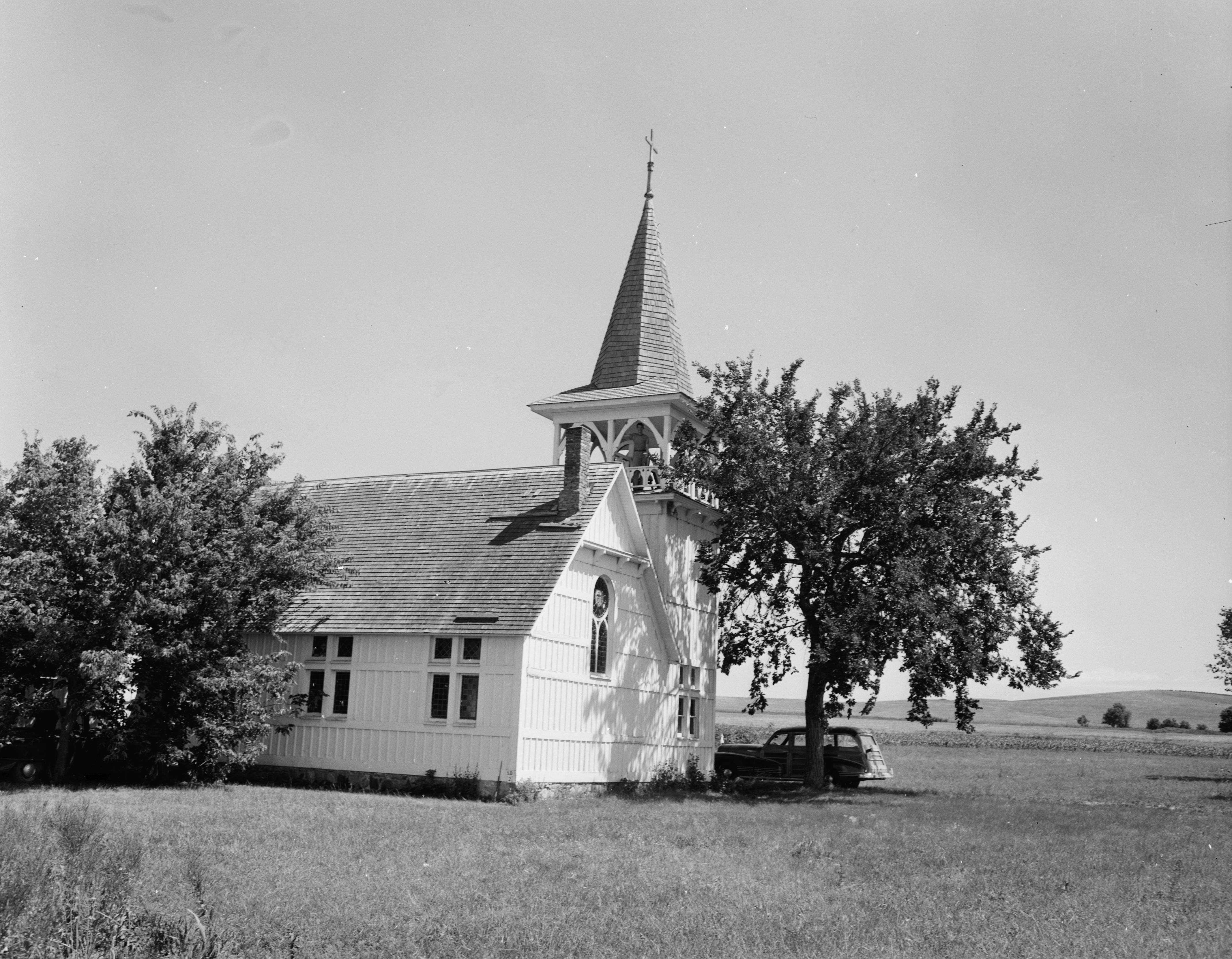
42°36′00″N 98°02′00″W / 42.6°N 98.033333°WVerdigre 3 Congregational Church and Manse 
March 16, 1972 Santee Sioux Reservation
42°50′19″N 97°50′46″W / 42.838611°N 97.846111°WSantee 4 Episcopal Church 
March 16, 1972 On the Missouri River in the Santee Sioux Reservation Santee 5 Gross State Aid Bridge 
June 29, 1992 County road 885 Rd over Verdigris Creek, 3.5 miles north and 0.2 miles west of Verdigre
42°39′16″N 98°02′34″W / 42.654444°N 98.042778°WVerdigre 6 Knox County Courthouse 
July 5, 1990 Main St. between Brazile and Bridge Sts.
42°36′32″N 97°52′37″W / 42.608889°N 97.876944°WCenter 7 Niobrara River Bridge 
November 12, 1992 Over the Niobrara River 1.3 miles northwest of Niobrara
42°46′00″N 98°02′55″W / 42.766667°N 98.048611°WNiobrara 8 Ponca Agency Archeological District 
July 12, 2006 Address Restricted Niobrara 9 Ponca Fort Site April 3, 1973 Address Restricted Verdel 10 Ponca Tribal Self-Help Community Building Historic District March 13, 2003 Approximately 3 miles southeast of Niobrara
42°42′51″N 98°05′12″W / 42.714167°N 98.086667°WNiobrara 11 Pospeshil Theatre 
September 28, 1988 123 Broadway
42°35′53″N 97°38′44″W / 42.598056°N 97.645556°WBloomfield Burned down; Bloomfield library was built in 2000 on former site[4] 12 Rad Sladkovsky June 29, 1982 At Pishelville, northwest of Verdigre
42°43′34″N 98°12′40″W / 42.72611°N 98.21111°W[5]Verdigre 13 St. Rose of Lima Catholic Church and School Complex March 21, 2011 1302-1316 W. 5th St.[6]
42°43′53″N 97°30′02″W / 42.731389°N 97.500556°WCrofton 14 Winnetoon Jail 
February 27, 1995 Junction of 1st St. and Sherman Ave.
42°30′52″N 97°57′43″W / 42.514444°N 97.961944°WWinnetoon 15 Z.C.B.J. Opera House 
July 6, 1988 4th Ave. and Main
42°35′48″N 98°02′00″W / 42.596778°N 98.033333°WVerdigre See also
- List of National Historic Landmarks in Nebraska
- National Register of Historic Places listings in Nebraska
References
- ^ The latitude and longitude information provided in this table was derived originally from the National Register Information System, which has been found to be fairly accurate for about 99% of listings. For about 1% of NRIS original coordinates, experience has shown that one or both coordinates are typos or otherwise extremely far off; some corrections may have been made. A more subtle problem causes many locations to be off by up to 150 yards, depending on location in the country: most NRIS coordinates were derived from tracing out latitude and longitudes off of USGS topographical quadrant maps created under the North American Datum of 1927, which differs from the current, highly accurate WGS84 GPS system used by Google maps. Chicago is about right, but NRIS longitudes in Washington are higher by about 4.5 seconds, and are lower by about 2.0 seconds in Maine. Latitudes differ by about 1.0 second in Florida. Some locations in this table may have been corrected to current GPS standards.
- ^ "National Register of Historic Places: Weekly List Actions". National Park Service, United States Department of the Interior. Retrieved on November 10, 2011.
- ^ Numbers represent an ordering by significant words. Various colorings, defined here, differentiate National Historic Landmark sites and National Register of Historic Places Districts from other NRHP buildings, structures, sites or objects.
- ^ Koertje, Norma. "Bloomfield Public Library". Nebraska Library Quarterly. 2000-06-25. Retrieved 2010-02-19.
- ^ Location derived from Murphy, D. National Register of Historic Places Inventory/Nomination: Rad Sladkovsky. National Park Service, March 1981. Accessed 2010-02-21. The NRIS lists the site as "Address Restricted".
- ^ The National Park Service announcement has the address as South 5th St. Per the church website, the actual address is West 5th St.
U.S. National Register of Historic Places Topics Lists by states Alabama • Alaska • Arizona • Arkansas • California • Colorado • Connecticut • Delaware • Florida • Georgia • Hawaii • Idaho • Illinois • Indiana • Iowa • Kansas • Kentucky • Louisiana • Maine • Maryland • Massachusetts • Michigan • Minnesota • Mississippi • Missouri • Montana • Nebraska • Nevada • New Hampshire • New Jersey • New Mexico • New York • North Carolina • North Dakota • Ohio • Oklahoma • Oregon • Pennsylvania • Rhode Island • South Carolina • South Dakota • Tennessee • Texas • Utah • Vermont • Virginia • Washington • West Virginia • Wisconsin • WyomingLists by territories Lists by associated states Other Municipalities and communities of Knox County, Nebraska Cities 
Villages Townships Addison | Bohemia | Central | Cleveland | Columbia | Creighton | Dolphin | Dowling | Eastern | Frankfort | Harrison | Herrick | Hill | Jefferson | Lincoln | Logan | Miller | Morton | Niobrara | North Frankfort | Peoria | Raymond | Spade | Sparta | Union | Valley | Verdigre | Walnut Grove | Washington | Western
Unincorporated
communityLindy
Indian reservations Ponca Reservation | Santee Sioux Reservation
Categories:- National Register of Historic Places in Nebraska by county
- Knox County, Nebraska
- Buildings and structures in Knox County, Nebraska
-


Wikimedia Foundation. 2010.