- Grouseland
Infobox_nrhp | name =Grouseland (William Henry Harrison House)
nrhp_type =nhl
caption =
location=Vincennes, Indiana
lat_degrees = 38 | lat_minutes = 41 | lat_seconds = 7.76 | lat_direction = N
long_degrees = 87 | long_minutes = 31 | long_seconds = 33.62 | long_direction = W
area =
built =1804
architect= William Lindsay
architecture= No Style Listed
designated=December 19 ,1960 cite web|url=http://tps.cr.nps.gov/nhl/detail.cfm?ResourceId=20&ResourceType=Building
title=Grouseland (William Henry Harrison House)|accessdate=2008-07-23|work=National Historic Landmark summary listing|publisher=National Park Service]
added =October 15 ,1966
governing_body = Private
refnum=66000018 cite web|url=http://www.nr.nps.gov/|title=National Register Information System|date=2007-01-23|work=National Register of Historic Places|publisher=National Park Service]Grouseland, the
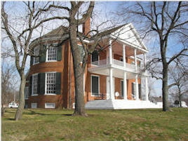
William Henry Harrison Mansion and Museum, is aNational Historic Landmark in architectural and historical fields. Grouseland is a large, two-story redbrick home built forWilliam Henry Harrison inVincennes, Indiana during his term asGovernor of theIndiana Territory . The mansion was completed in1804 and reportedly dubbed "Grouseland" by William Henry Harrison, due to the abundance ofgrouse in the area.During Harrison's governorship of the
Indiana Territory , Grouseland was the focal point of the social and official life of the territory. As the capital of theNorthwest Territory , more territory was governed from Vincennes than any city outsideWashington, D.C. . [Indiana Business Journal; link below] Grouseland was home to Harrison until 1812. It remained in the Harrison family until the late 1840's.The mansion includes the council chamber where Harrison met with representatives from various American Indian tribes. In
1805 , Harrison negotiated theTreaty of Grouseland with a number of important Indian leaders, includingLittle Turtle andBuckongahelas . Harrison had two confrontations with theShawnee leaderTecumseh at Grouseland in 1810 and 1811. (seeTecumseh's War ). Harrison's thirteen treaties with Native American leaders resulted in millions of acres of land being acquired by the United States.Grouseland was built from local materials by skilled labor. The architect was William Lindsay.Today, Grouseland is owned by the
Daughters of the American Revolution and a non-professional board of directors oversees the policies and management of this structure. The main campus ofVincennes University is adjacent to the property, and other state historic buildings, such as the Territory Capitol building, have been moved to the property. [ [http://www.spiritofvincennes.org/rendezvous/historic/ http://www.spiritofvincennes.org/rendezvous/historic/] ]References
External links
* [http://www.grouselandfoundation.org/ Official website]
* [http://tps.cr.nps.gov/nhl/detail.cfm?ResourceId=20&ResourceType=Building National Park Service, Historic Landmarks program]
*http://www.insideindianabusiness.com/newsitem.asp?ID=28887 'Vincennes Hoping History Can Bring Tourism'] Indiana Business Journal
Wikimedia Foundation. 2010.