- Indiana Territory
Infobox Former Subdivision
width = 260
native_name =
conventional_long_name = Territory of Indiana
common_name = Indiana Territory
nation = theUnited States
subdivision = Organized incorporated territory|
event_start =
date_start = July 4
year_start = 1800
event_end = Granted Statehood
year_end = 1816
date_end = November 7
event1 = Treaty of Grouseland signed
date_event1 = March, 1805
event2 =Michigan Territory created
date_event2 = June 30, 1805
event3 = Representation in Congress
date_event3 = Dec. 12, 1805
event4 =Illinois Territory created
-Legislature popularly elected
-Tecumseh's War
-War of 1812
-Constitution drafted & adopted
date_event4 = March 1, 1809
Nov. 1809
1811–1812
1812–1814
June 1816
event5 =
date_event5 =
event6 =
date_event6 =
event7 =
date_event7 =
event_pre =
date_pre = |
p1 = Northwest Territory
flag_p1 = US flag 15 stars.svg
s1 = Indiana
flag_s1 = Flag of Indiana.svg
s2 = Michigan Territory
flag_s2 = US flag 15 stars.svg
s3 = Illinois Territory
flag_s3 = US flag 15 stars.svg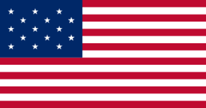
symbol =
symbol_type =
image_map_caption = |
stat_area1 =
stat_pop1 = 2632
stat_year1 = 1800
stat_area2 =
stat_pop2 = 63897
stat_year2 = 1816|
capital = Vincennes (1800–1813)
Corydon (1813–1816)
government_type = Organized incorporated territory
title_leader = Governor
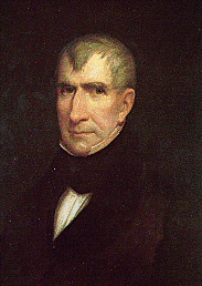
leader1 = William Henry Harrison
year_leader1 = 1800-1812
leader2 = Thomas Posey
year_leader2 = 1813-1816
title_deputy = Secretary
deputy1 = John Gibson
year_deputy1 = 1800-1816Indiana Territory was an
organized territory of theUnited States from 1800 to 1816, created by Act of Congress and signed into law by PresidentJohn Adams onMay 7 ,1800 , effective onJuly 4 . It was the first new territory created from lands of theNorthwest Territory , which had been organized in 1787 by theNorthwest Ordinance . The territory originally contained approximately 259,824 square miles (430,000 km²) of land. The territory ceased to exist when Indiana statehood was approved in 1816.The territory was first governed by
William Henry Harrison who oversaw the negotiation of treaties opening up the territory to settlement, the establishment of a popularly elected government, and the basic development of infrastructure. At the outbreak ofTecumseh's War the territory was on the front line of battle and Harrison led the territory's militia and regulars in theBattle of Tippecanoe , and then in the subsequent invasion ofCanada during theWar of 1812 .Thomas Posey was appointed to the vacant governorship, but the legislature dominated the territorial government for its remaining years. In June 1816 a constitutional convention was held and a state government was formed. The territory was dissolved on November 7, 1816, by an act of Congress granting statehood toIndiana .Original boundaries
The original boundaries of the territory included the area of the Northwest Territory west of a line running from the bank opposite the mouth of the
Kentucky River toFort Recovery , and from there due northward along a line approximately 83 deg 45 min W longitude. The territory included all of present-dayIndiana ,Illinois ,Wisconsin , as well as the portions ofMinnesota . It also included almost all of the upper peninsula of present-dayMichigan and the western half of the lower peninsula. It also included a narrow strip of present-dayOhio lying to the north and west of Fort Recovery. [Jervis, 53–54] This latter parcel became part of the state of Ohio when it was admitted to the Union in 1803. [Jervis, 110] The eastern half of Michigan was added to the Indiana Territory at that time. The area of the territory was reduced in 1805 by the creation of theMichigan Territory , and in 1809 by the creation of theIllinois Territory . [Jervis, 112]Governors
History
Background
The
Northwest Territory was formed by theCongress of the Confederation onJuly 13 ,1787 , and included all land between theAppalachia and theMississippi River , theGreat Lakes and theOhio River . This single territory became the states ofOhio ,Michigan ,Indiana ,Illinois ,Wisconsin , and easternMinnesota . The Northwest Territory act had all the newly acquired territory surveyed according to theThe Land Ordinance of 1785 for future development by the United States. The act also provided an administration to oversee the territory. [cite web|url=http://rs6.loc.gov/cgi-bin/ampage?collId=llsl&fileName=001/llsl001.db&recNum=173|title=Congressional Record|publisher=1st United States Congress|year=Aug. 7, 1789|pages=p. 50–51|accessdate=2008-09-30]At the time the territory was created, there were only three American settlements in what would later become the Indiana Territory, Vincennes, Kaskaskia and Clark's Grant. The entire population was under five-thousand Europeans. The Native American population was estimated to be near twenty-thousand, but possibly as high as seventy-five thousand. [Law, p. 57]
In 1785, the
Northwest Indian War began. In an attempt to end the native rebellion, the Miami town ofKekionga was unsuccessfully attacked by GeneralJosiah Harmar and Northwest Territory governorArthur St. Clair . [Dowd, pp. 113–114] St. Clair's defeat is considered the worst defeat of the U.S. army by Native Americans in history. The defeat led to the appointment of General "Mad Anthony" Wayne who organized theLegion of the United States and defeated a Native American force at theBattle of Fallen Timbers in 1794. In 1795 theTreaty of Greenville was signed, taking a slice of eastern Indiana for the United States. Fort Miamis at Kekionga was occupied by the United States, who rebuilt it as Fort Wayne. The powerful Miami nation would consider themselves allies with the United States after the treaty, but a new resistance movement began underShawnee ChiefTecumseh . [Funk, p. 38]Formation
On
July 4 ,1800 , the Indiana Territory was established out of Northwest Territory in preparation forOhio 's statehood. The capitol of the new territory was Vincennes, a former French trading post and one of the only white settlements in the vast territory. [cite web|url=http://www.in.gov/history/6874.htm|title= "The Indiana Historian" - Indiana Territory|publisher=IN.gov|author=Indiana Historical Bureau|accessdate=2008-05-17] The name "Indiana" meant "Land of the Indians", and referred to the fact that most of the area north of theOhio River was still inhabited by Native Americans. (Kentucky , South of the Ohio River, had been a traditional hunting ground for tribes that resided north of the river, and early American settlers in Kentucky referred to the North bank as the land of the Indians.) In 1768, several colonies purchased theIroquois claim to the northwest and established the Indiana Land Company to hold that claim, the first recorded use of the word "Indiana". The claim to the land was disputed byVirginia , and the company's claim was extinguished in a 1798United States Supreme Court case. Two years later, Congress used the name of the company and applied it to the new territory. [cite web|url=http://www.in.gov/history/2686.htm|title=The naming of Indiana|publisher=IN.gov|author=Indiana Historical Bureau|accessdate=2008-09-29]Originally the territory had just three counties: St. Clair (present day Illinois and Wisconsin), Randolph County (present day Illinois), and Knox (present day Indiana). At its greatest extent, Indiana Territory contained all of modern Illinois, Michigan, Wisconsin and part of Minnesota. [cite web|url=http://www.indwes.edu/faculty/bcupp/Indiana/counties.htm|title=Indiana Counties|publisher=
Indiana Wesleyan University |accessdate=2008-10-10] The first Governor of the Territory wasWilliam Henry Harrison . Harrison County was named in honor of Harrison, who later become the ninthPresident of The United States . [cite web|url=http://www.centerforhistory.org/indiana_history_main2.html|publisher=Northern Indiana Center for History|title=Indiana History Chapter Two|accessdate=2008-10-09]William Henry Harrison served as the Governor of the Indiana Territory fromMay 13 ,1800 toDecember 28 ,1812 . Between his appointment in May and his arrival in the territory, John Gibson, the Territorial Secretary, served as acting-governor fromJuly 4 ,1800 until Harrison arrived in the territory onJanuary 10 ,1801 . [Dunn, p. 228] The governor was assisted in governing the territory by a three member panel called the General Court. The court served as both the highest legislative and judicial authority in the territory and its members were appointed by the governor. [Dunn, p. 215]As governor, Harrison had wide ranging powers in the new territory, including the authority to appoint all territory officials and the territorial legislature, and the authority to divide the territory into districts. [Dunn, p. 225–226] A primary responsibility as territorial governor was to obtain title to Native American lands so that white settlement could expand in the area and the region could attain statehood. [Hall, pp. 66–67] Harrison was also eager to expand the territory for personal reasons, as his own political fortunes were tied to Indiana's rise to statehood. In 1803 President
Thomas Jefferson granted Harrison authority to negotiate and conclude treaties with the Native American tribes in the territory. Harrison oversaw the creation of thirteen treaties, purchasing more than convert|60000000|acre|km2 of land from Native American leaders, including most present day southernIndiana .Whitting, p. 7]The
Treaty of Vincennes was the first treaty Harrison negotiated with his new power. In 1803 he invited the leaders on the local tribes to Vincennes where they signed a treaty recognizing American possession of the Vincennes tract. This area had been captured byGeorge Rogers Clark in theAmerican Revolutionary War from the French. TheTreaty of Grouseland in 1805 was thought by Harrison to have appeased Native Americans, but tensions remained high on the frontier and neared the breaking the point after the 1809Treaty of Fort Wayne , in which Harrison illegally purchased more than convert|250000000|acre|km2 of American Indian land.The availability of new cheap land led to a rapid increase in the population of the territory, with thousands of new settlers entering the region every year. Large settlements began to spring up on the periphery of the territory around the
Great Lakes , the Ohio River, the Wabash River, and the Mississippi River. Much of the interior, though, remained inhabited by the Native American tribes and was left unsettled.District of Louisiana
From
October 1 ,1804 untilJuly 4 ,1805 , administrative powers of theDistrict of Louisiana were extended to the governor and judges of the Indiana Territory as a temporary measure to govern the newly purchased lands. Under the terms of the act establishing the temporary government, the Governor and Judges of the Indiana Territory were supposed to meet twice a year inSt. Louis, Missouri . Residents of the new district objected to many of the provisions of the new United States government, like their imposition of common law over the civil law they had been living under. OnJuly 4 ,1805 , the territory west of the Mississippi became theLouisiana Territory .cite web|title=Congressional Record|publisher=8th United States Congress|year=March 3, 1805|url=http://rs6.loc.gov/cgi-bin/ampage?collId=llsl&fileName=002/llsl002.db&recNum=368|pages=331|accessdate=2008-10-10]One of the most notable events during this period was the
Treaty of St. Louis in which the Sac and Fox tribes ceded northeastern Missouri, northern Illinois and southern Wisconsin to the United States. Resentments over this treaty were to cause the tribes to side with the British during theWar of 1812 in raids along the Missouri, Ohio and Mississippi Rivers and was to spur theBlack Hawk War in 1832. [Kappler, p. 1804]Politics
[
 thumb|200px|
William Henry Harrison , the 1st Governor of Indiana Territory from 1801 to 1812, and the 9thPresident of the United States ]In 1803, Harrison began to lobby Congress to repeal Article Six of the
Northwest Ordinance , which would result in slavery being permitted in the Indiana Territory. He claimed legalizing slavery was necessary to make the region more appealing to settlers and ultimately make the territory economically viable.Gresham, p. 21] That same year Harrison had indenturing legalized by the General Court. [Dunn, p. 218] The territory was granted representation in theUnited States Congress in 1805, and pro-slaveryBenjamin Parke became the territory's first representative. Parke used his position to get Congress to support Harrison's appeal. He was able pass legislation to have Article Six suspended for ten years, and the territories covered by the ordinance were granted the ability to legalize slavery if they so chose. By the same act, Congress removed the General Court's legislative power and created a legislative council that was to be elected by popular vote. [Dunn, p. 246]Harrison's attempts caused a significant stir among the many
Quakers who had settled in the eastern part of the territory, who responded by forming an anti-slavery party. In the 1805 election,Davis Floyd of Clark County, was the only anti-slavery representative elected to the council. Harrison's measures to legalize slavery where hampered by the representatives from St. Clair County because they refused to authorize slavery unless Harrison would in turn endorse their request for their own territory. Harrison declined to endorse their plan for a new territory, so they continued to withhold support for the slavery law as a bargaining piece. [Dunn, pp. 249 & 298] In 1809, Congress received a petition from St. Clair County requesting to become their own territory, and despite Harrison's lack of approval, theIllinois Territory was created. The same year, Congress granted the Indiana Territory the right to elect a House of Representatives. Harrison found himself at odds with the legislature when theabolition ist party came to power in that year's election. They promptly rebuffed many of his plans for slavery and repealed the indenturing laws he had passed in 1803. [Dunn, p. 258]The capital of the territory remained in Vincennes for thirteen years. After the territory was reorganized in 1809 and the Illinois Territory was split off, Vincennes was then on the far west edge of the Indiana Territory. Due to this, the legislature made plans to move the capital to be more centralized with the population. Madison, Jeffersonville, and Corydon competed to become the new capitol. Harrison favored Corydon, a town he had founded and named, and where he owned an estate. The new capitol building was finished in 1813 and the government quickly relocated to Corydon after the outbreak of the
War of 1812 for fear of an attack on Vincennes. [Gresham, p. 25]Tecumseh's War
[

Treaty of Fort Wayne .]An Indian resistance movement against U.S. expansion had been growing around the
Shawnee brothersTecumseh andTenskwatawa (The Prophet) that became known asTecumseh's War . Tenskwatawa convinced the native tribes that they would be protected by the Great Spirit and no harm could befall them if they would rise up against the whites. He encouraged resistance by telling the tribes to only pay white traders half of what they owed, and to give up all the white man's ways, including their clothing, whiskey, and guns. [Langguth, pp. 158-160] In 1810, Tecumseh, with about 400 armed warriors, traveled to Vincennes were he confronted Harrison and demanded that theTreaty of Fort Wayne be rescinded. Although Harrison refused, the war party left peacefully, but Tecumseh was angry and threatened retaliation. After the meeting Tecumseh journeyed to meet with many of the tribes in the region, hoping to create a confederation with which to battle the Americans. [Langguth, pp. 164-166]In 1811, while Tecumseh was still away, Harrison was authorized by Secretary of War
William Eustis to march against the nascent confederation, as a show of force. Harrison moved north with an army of more than one thousand men in an attempt to intimidate the Shawnee into making peace. The ploy failed, and the tribes launched a surprise attack on Harrison's army early on the morning ofNovember 6 . The ensuing battle became known as theBattle of Tippecanoe . Harrison ultimately won his famous victory atProphetstown , next to the Wabash andTippecanoe River s. Harrison was publicly hailed as a national hero, despite the fact that his troops had greatly outnumbered the Indian forces, and had suffered many more casualties. [Langguth, pp. 167–169] The battle earned Harrison national fame, and the nickname "Old Tippecanoe". [Cleeves, p. 3 ] The victory opened up central Indiana to settlement and allowed settlers to safely venture beyond the southern periphery of the state. [Dunn, p. 282]War of 1812
The war between Tecumseh and Harrison merged with the War of 1812 when the Indian Confederation allied with the British in
Canada . In May of 1812, a meeting of all the tribal leaders in the region was held in the Miami village of Mississinewa hosted by ChiefLittle Turtle . Most of the tribes decided to remain neutral during the conflict and rejected Tecumseh's plans of continued rebellion. [Dunn, p. 266] Despite their rejection, Tecumseh continued to lead his dwindling army against the Americans, and moved farther north where he could be supported by the British army. His followers who remained behind continued raiding the countryside and engaged in theBattle of Fort Harrison , which is considered to be the United States' first land victory during the war. [Dunn, p. 267] John served as acting Governor during theWar of 1812 while Harrison was leading the army. After Harrison was replaced in June 1812, Gibson continued as acting-governor until incoming governorThomas Posey arrived in May 1813. [Dunn, p. 283]Numerous other battles that occurred in the modern state of Indiana include the
Siege of Fort Wayne , the Pigeon Roost Massacre and theBattle of the Mississinewa . Most of the Native Americans remained passive throughout the war, but there were many incidents between settlers and the tribes, leading to the deaths of hundreds in the territory. TheTreaty of Ghent , signed in 1814, ended the War and relieved American settlers from their fears of the nearby British and their Indian allies. [cite web|url=http://www.americanheritage.com/articles/magazine/ah/1960/1/1960_1_28.shtml|title="The Peace of Christmas Eve"|publisher=American Heritage.com|author=Engleman, Fred L. |accessdate=2008-05-21]tatehood
In 1812,
Jonathan Jennings defeated Harrison's chosen candidate and became the territory's representative to Congress. [Dunn, p. 263] Jennings used his position there to attempt to speed up Indiana's path to statehood by immediately introducing legislation to grant Indiana statehood, even though the population of the entire territory was under 25,000. Jennings did this against the wishes of incoming governor Thomas Posey, and there was noted disagreement between the two men on the subject. No action was taken on the legislation at the time, though, because of the outbreak of the War of 1812.Dunn, p. 293]Thomas Posey was appointed territorial Governor on
March 3 ,1813 , and served until the state's first Governor was sworn into office onNovember 7 ,1816 . Posey, who was age sixty-two and in poor health, had created a rift in the politics of the territory by refusing to reside in the capital of Corydon, instead living in Jeffersonville to be closer to his doctor. [According to some sourcesThomas Posey refused to live in Corydon because of his ongoing quarrel withDennis Pennington . (Gresham, p. 22)] [Dunn, p. 283–284] He further complicated matters by being a supporter of slavery, much to the chagrin of opponents like Jennings,Dennis Pennington , and others who dominated the Territorial Legislature, and who sought to use the bid for statehood to permanently end the possibility of slavery in the state.In February 1815, the
United States House of Representatives began debate on granting Indiana Territory statehood. In early 1816, the Territory approved acensus and Pennington was named to be the census enumerator. The population of the territory was found to be 63,897, [Haymond, p. 181] above the limit required for statehood that was stated in the Northwest Ordinance. OnMay 13 ,1816 , the Enabling Act was passed and the state was granted permission to form a government subject to the approval of Congress. [Funk, p. 42] A constitutional convention met in 1816 in Corydon. The state's first constitution was drawn up on June 10, and elections were held in August to fill the offices of the new state government. In November of that year the constitution was approved by Congress and the territorial government was dissolved, ending the existence of the Indiana Territory and replacing it with the State of Indiana. [Funk, p. 35] [cite web|url=http://www.centerforhistory.org/indiana_history_main3.html|publisher=Indiana Center For History|title="Indiana History Chapter three"|accessdate=2008-05-17]Commemoration
The Indiana Territory is celebrated at an annual event in Corydon centered around the territorial capitol building. The festival includes actors in period dress who reenact events and pretend to be some of the important settlers of early Indiana. [cite web|url=http://www.indianaterritoryfestival.org/|title=Indiana Territory Festival|accessdate=2008-10-01|publisher=Harrison County Tourism Board] Other commemorative festivals occur in Vincennes and Madison, and the history of the period is noted on historic markers and monuments across the former territory.
ee also
*
Historic regions of the United States
*
*Indiana References
ources
*cite book|author=Cleaves, Freeman|title= Old Tippecanoe: William Henry Harrison and His Time|location New York|publisher= Scribner's|year= 1939
*cite book|author=Dowd, Gregory Evans|title= A Spirited Resistance: The North American Indian Struggle for Unity, 1745-1815|publisher=Johns Hopkins University Press|location= Baltimore and London: Johns Hopkins University|year= 1992|isbn=0801842360
*cite book|author=Funk, Arville L. |title=A Sketchbook of Indiana History|year=1969, revised 1983|publisher=Christian Book Press|location=Rochester, Indiana
*cite book|title=Life of Walter Quintin Gresham 1832-1895cl|author=Gresham,Matilda |publisher=Rand McNally & company|year=1919
*cite book|title= A Topographical Description of the State of Ohio, Indiana Territory, and Louisiana| author=Jervis, Cutler & Le Raye, Charles| publisher=Ayer Publishing|year= 1971|ibsn=9780405028397
*cite book|url=http://books.google.com/books?id=LxgVAAAAYAAJ&, |title=An Illustrated History of the State of Indiana|author= Haymond, William S|year=1879|publisher=S.L. Marrow & Co.
*cite book|author=Kappler, Charles J. ed|url= http://digital.library.okstate.edu/kappler/vol2/treaties/sau0074.htm#mn3 |title=Treaty with the Sauk and Foxes, 1804|location=Washington|publisher=Government Printing Office |year= 1904.November 3 ,1804 7 Stat., 84. RatifiedJanuary 25 ,1805 , proclaimedFebruary 21 ,1805 |accessdate=2008-09-30
*cite book|title=Union 1812:The Americans Who Fought the Second War of Independence|author= Langguth, A. J.|isbn=0743226189|year=2006|publisher=Simon & Shuster|location= New York
*cite book|title="The Colonial History of Vincennes"|url=http://books.google.com/books?id=VGYaAAAAMAAJ| author=Law, Judge |publisher=Harvey, Mason & Co.|year=1858, reproduced 2006
*cite book| url=http://books.google.com/books?id=4KYEAAAAYAAJ|title= A Sketch of the Life and Public Services of William Henry Harrison|author=Whiting, Isaac|year= 1840|publisher=I. N. WhitingExternal links
* [http://www.in.gov/history/6874.htm "The Indiana Historian" - Indiana Territory] , [http://www.in.gov/history/files/interritory.pdf PDF] , retrieved
2008-05-16
* [http://www.in.gov/history/6214.htm Act creating Indiana Territory] , retrieved2008-05-16
* [http://resource.smartdesktop.org/rescon/?sm=fl9%3BPublisher25%3BIndiana+Historical+Bureaufl8%3BStandard15%3BSS.USH.1.4+2001 Other acts concerning the Indiana Territory]

Wikimedia Foundation. 2010.