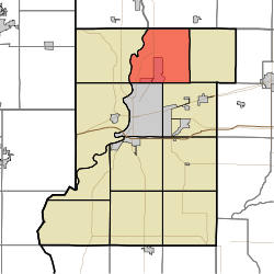
- Otter Creek Township, Vigo County, Indiana
-
Otter Creek Township — Township — Location in Vigo County Coordinates: 39°33′43″N 87°20′53″W / 39.56194°N 87.34806°WCoordinates: 39°33′43″N 87°20′53″W / 39.56194°N 87.34806°W Country United States State Indiana County Vigo Government – Type Indiana township Area – Total 35.66 sq mi (92.36 km2) – Land 35.29 sq mi (91.4 km2) – Water 0.37 sq mi (0.97 km2) 1.05% Elevation 509 ft (155 m) Population (2000) – Total 9,059 – Density 256.7/sq mi (99.1/km2) ZIP codes 47805, 47874 GNIS feature ID 0453699 Otter Creek Township is one of twelve townships in Vigo County, Indiana, USA. As of the 2000 census, its population was 9,059.[1]
Contents
Geography
According to the United States Census Bureau, Otter Creek Township covers an area of 35.66 square miles (92.4 km2); of this, 35.29 square miles (91.4 km2) (98.96 percent) is land and 0.37 square miles (0.96 km2) (1.05 percent) is water.
Cities, towns, villages
- North Terre Haute
- Terre Haute (north edge)
Unincorporated communities
- Atherton
- Burnett
- Markles
- Otter Creek Junction
- Sandcut
- Spelterville
Adjacent townships
- Florida Township, Parke County (northeast)
- Nevins Township (east)
- Lost Creek Township (southeast)
- Harrison Township (southwest)
- Sugar Creek Township (southwest)
- Fayette Township (west)
- Clinton Township, Vermillion County (northwest)
Cemeteries
The township contains these ten cemeteries: Denny, Evans, Haven, Kennedy, Markles, Phillips, Roselawn Memorial Park, Steveson, Stewart and Wood.
Airports and landing strips
- Sky King Airport
School districts
Political districts
- Indiana's 8th congressional district
- State House District 42
- State House District 43
- State Senate District 38
References
- United States Census Bureau 2007 TIGER/Line Shapefiles
- United States Board on Geographic Names (GNIS)
- IndianaMap
External links
- Indiana Township Association
- United Township Association of Indiana
- Vigo County, Indiana, official website
- History of Otter Creek Township
Municipalities and communities of Vigo County, Indiana City Towns Townships Fayette | Harrison | Honey Creek | Linton | Lost Creek | Nevins | Otter Creek | Pierson | Prairie Creek | Prairieton | Riley | Sugar Creek
Unincorporated
communitiesAllendale | Atherton | Barnhart Town | Blackhawk | Brown Jug Corner | Burnett | Cherryvale | Coal Bluff | Cobb | Deming Woods | Dewey | Duane Yards | East Glenn | Ehrmandale | Ferguson Hill | Fontanet | Glenn Ayr | Gospel Grove | Grange Corner | Harrison | Hickory Island | Hutton | Keller | Larimer Hill | Lewis | Libertyville | Liggett | Marion Heights | Markles | New Goshen | North Terre Haute | Otter Creek Junction | Parkview | Pimento | Pine Ridge | Prairie Creek | Prairieton | Preston | Saint Mary-of-the-Woods | Sandcut | Sandford | Shepardsville | Shirkieville | Southwood | Spelterville | Spring Hill | State Line | Swalls | Tabertown | Taylorville | Tecumseh | Terre Town | Toad Hop | Twelve Points | Vigo | Whitcomb Heights | Woodgate | Youngstown
Categories:- Townships in Vigo County, Indiana
- Terre Haute metropolitan area
Wikimedia Foundation. 2010.

