- West Terre Haute, Indiana
Infobox Settlement
official_name = West Terre Haute, Indiana
settlement_type =Town
nickname =
motto =
imagesize =
image_caption =
image_
imagesize =
image_caption =
image_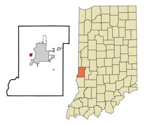
mapsize = 250x200px
map_caption = Location of West Terre Haute in the state ofIndiana
mapsize1 =
map_caption1 =subdivision_type = Country
subdivision_name =United States
subdivision_type1 = State
subdivision_name1 =Indiana
subdivision_type2 = County
subdivision_name2 = Vigo
subdivision_type3 = Township
subdivision_name3 = Sugar Creek
government_footnotes =
government_type =
leader_title =
leader_name =
leader_title1 =
leader_name1 =
established_title =
established_date =area_footnotes =
unit_pref = Imperial
area_magnitude =
area_total_km2 = 2.0
area_land_km2 = 2.0
area_water_km2 = 0.0
area_total_sq_mi = 0.8
area_land_sq_mi = 0.8
area_water_sq_mi = 0.0population_as_of = 2000
population_footnotes =
population_total = 2330
population_density_km2 = 1190.1
population_density_sq_mi = 3082.4timezone = Eastern (EST)
utc_offset = -5
timezone_DST = EDT
utc_offset_DST = -4
elevation_footnotes =
elevation_m = 143
elevation_ft = 469
latd = 39 |latm = 27 |lats = 49 |latNS = N
longd = 87 |longm = 26 |longs = 56 |longEW = Wpostal_code_type =
ZIP code
postal_code = 47885
area_code = 812
blank_name = FIPS code
blank_info = 18-83384GR|2
blank1_name = GNIS feature ID
blank1_info = 0445815GR|3
website =
footnotes =West Terre Haute is a town in Sugar Creek Township,
Vigo County,Indiana , on the western side of theWabash River nearTerre Haute, Indiana . The population was 2,330 at the 2000 census.Geography
West Terre Haute is located at coor dms|39|27|49|N|87|26|56|W|city (39.463636, -87.448963)GR|1.
According to the
United States Census Bureau , the town has a total area of 0.8square mile s (2.0km² ), all of it land.Demographics
As of the
census GR|2 of 2000, there were 2,330 people, 895 households, and 620 families residing in the town. Thepopulation density was 3,082.4 people per square mile (1,183.7/km²). There were 1,046 housing units at an average density of 1,383.8/sq mi (531.4/km²). The racial makeup of the town was 97.55% White, 0.04% African American, 0.52% Native American, 0.47% Asian, 0.17% Pacific Islander, 0.04% from other races, and 1.20% from two or more races. Hispanic or Latino of any race were 0.56% of the population.There were 895 households out of which 36.3% had children under the age of 18 living with them, 48.0% were married couples living together, 16.0% had a female householder with no husband present, and 30.7% were non-families. 26.4% of all households were made up of individuals and 12.1% had someone living alone who was 65 years of age or older. The average household size was 2.60 and the average family size was 3.12.
In the town the population was spread out with 29.1% under the age of 18, 9.6% from 18 to 24, 30.3% from 25 to 44, 19.2% from 45 to 64, and 11.8% who were 65 years of age or older. The median age was 32 years. For every 100 females there were 93.2 males. For every 100 females age 18 and over, there were 88.7 males.
The median income for a household in the town was $25,954, and the median income for a family was $30,469. Males had a median income of $25,854 versus $19,618 for females. The
per capita income for the town was $11,887. About 16.5% of families and 20.7% of the population were below thepoverty line , including 27.4% of those under age 18 and 11.1% of those age 65 or over.Community
St. George's Episcopal Church serves this community, along with several other churches of various denominations, including
Baptist ,Roman Catholic ,United Methodist andUnited Church of Christ .West Terre Haute is not physically connected to Terre Haute. They are separated by the
Wabash River . Bridges connecting the two are located onUS 40 andI-70 . They are distinct political entities. West Terre Haute has its own town council, police department, street department, sewer department, and fire department, though the Vigo County Sheriff's Department has jurisdiction in both cities.An unofficial local nickname for one specific area of West Terre Haute is called "Toad Hop," though this actually refers to the mostly wooded area between the
I-70 exit andUS 40 . More commonly used is "West-T," though this also carries no official status.West Terre Haute is in theVigo County School Corporation . West Terre Haute has 3 schools:
*West Vigo Elementary School-Grades PreK-5
*West Vigo Middle School-Grades 6-8
*West Vigo High School-Grades 9-12Transportation
West Terre Haute is the last community in Indiana encountered travelling westbound on
US 40 before crossing intoIllinois .Interstate 70 does not pass through West Terre Haute itself but skirts its southern edge. There are two exits onI-70 for West Terre Haute: Exit #1 (eastbound only) onto U.S. 40 and Exit #3 onto Darwin Road, though it is also marked forSaint Mary-of-the-Woods College , which is five miles northwest of West Terre Haute.References
External links
Wikimedia Foundation. 2010.