- National Register of Historic Places listings in Noble County, Oklahoma
-
 Location of Noble County in Oklahoma
This is a list of the National Register of Historic Places listings in Noble County, Oklahoma.
This is intended to be a complete list of the properties and districts on the National Register of Historic Places in Noble County, Oklahoma, United States. The locations of National Register properties and districts for which the latitude and longitude coordinates are included below, may be seen in a Google map.[1]
There are 12 properties and districts listed on the National Register in the county.
-
- This National Park Service list is complete through NPS recent listings posted November 10, 2011.[2]
Current listings
[3] Landmark name [4] Image Date listed Location City or town Summary 1 First National Bank and Trust Company Building May 16, 1979 300 W. 6th St.
36°17′10″N 97°17′07″W / 36.286111°N 97.285278°WPerry 2 Morrison Baptist Church September 28, 1984 202 3rd St.
36°17′55″N 97°00′27″W / 36.298611°N 97.0075°WMorrison 3 Morrison Suspension Bridge May 23, 1980 East of Morrison off U.S. Route 64
36°18′30″N 96°57′05″W / 36.308333°N 96.951389°WMorrison 4 Noble County Courthouse August 23, 1984 Courthouse Square
36°17′12″N 97°17′11″W / 36.286667°N 97.286389°WPerry 5 Perry Armory September 8, 1988 Delaware and 14th Sts.
36°17′13″N 97°17′57″W / 36.286944°N 97.299167°WPerry 6 Perry Courthouse Square Historic District September 2, 2003 Roughly bounded by Birch, Elm, 6th and 7th Perry 7 Perry Lake Park June 1, 2007 1520 S. 4th St. Perry 8 Rein School September 8, 1988 Off U.S. Route 177
36°33′55″N 97°04′07″W / 36.565278°N 97.068611°WPonca City 9 Renfrow Building September 28, 1984 127 W. Main St.
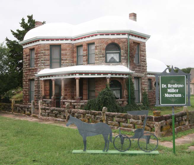
36°31′42″N 97°26′41″W / 36.528333°N 97.444722°WBillings 10 Renfrow House 
September 28, 1984 Graves St. and Broadway
36°31′39″N 97°26′43″W / 36.5275°N 97.445278°WBillings 11 Sumner School April 26, 1996 County Road N3300, 2 miles north of U.S. Route 64
36°19′06″N 97°07′21″W / 36.318333°N 97.1225°WMorrison 12 Wolleson-Nicewander Building May 16, 1979 615 Delaware St.
36°17′14″N 97°17′10″W / 36.287222°N 97.286111°WPerry See also
- List of National Historic Landmarks in Oklahoma
- National Register of Historic Places listings in Oklahoma
References
- ^ The latitude and longitude information provided in this table was derived originally from the National Register Information System, which has been found to be fairly accurate for about 99% of listings. For about 1% of NRIS original coordinates, experience has shown that one or both coordinates are typos or otherwise extremely far off; some corrections may have been made. A more subtle problem causes many locations to be off by up to 150 yards, depending on location in the country: most NRIS coordinates were derived from tracing out latitude and longitudes off of USGS topographical quadrant maps created under the North American Datum of 1927, which differs from the current, highly accurate WGS84 GPS system used by Google maps. Chicago is about right, but NRIS longitudes in Washington are higher by about 4.5 seconds, and are lower by about 2.0 seconds in Maine. Latitudes differ by about 1.0 second in Florida. Some locations in this table may have been corrected to current GPS standards.
- ^ "National Register of Historic Places: Weekly List Actions". National Park Service, United States Department of the Interior. Retrieved on November 10, 2011.
- ^ Numbers represent an ordering by significant words. Various colorings, defined here, differentiate National Historic Landmark sites and National Register of Historic Places Districts from other NRHP buildings, structures, sites or objects.
- ^ "National Register Information System". National Register of Historic Places. National Park Service. . http://nrhp.focus.nps.gov/natreg/docs/All_Data.html.
U.S. National Register of Historic Places Topics Lists by states Alabama • Alaska • Arizona • Arkansas • California • Colorado • Connecticut • Delaware • Florida • Georgia • Hawaii • Idaho • Illinois • Indiana • Iowa • Kansas • Kentucky • Louisiana • Maine • Maryland • Massachusetts • Michigan • Minnesota • Mississippi • Missouri • Montana • Nebraska • Nevada • New Hampshire • New Jersey • New Mexico • New York • North Carolina • North Dakota • Ohio • Oklahoma • Oregon • Pennsylvania • Rhode Island • South Carolina • South Dakota • Tennessee • Texas • Utah • Vermont • Virginia • Washington • West Virginia • Wisconsin • WyomingLists by territories Lists by associated states Other Municipalities and communities of Noble County, Oklahoma City 
Towns Unincorporated
communitiesCeres | Lucien | Otoe | Sumner
Categories:- Noble County, Oklahoma
- National Register of Historic Places in Oklahoma by county
- Buildings and structures in Noble County, Oklahoma
-

Wikimedia Foundation. 2010.