- U.S. Route 177
-
U.S. Route 177

Route information Auxiliary route of US 77 Length: 233 mi (375 km) Existed: 1929[1] – present Major junctions South end: 
 US-70 / SH-199 at Madill, OK
North end:  US-81 at South Haven, KS
Highway system United States Numbered Highways
List • Bannered • Divided • ReplacedU.S. Route 177 is a spur of U.S. Route 77. It currently runs for 233 miles (375 km) from South Haven, Kansas at US 81 to Madill, Oklahoma at US-70. It passes through the states of Kansas and Oklahoma.
Contents
Route description
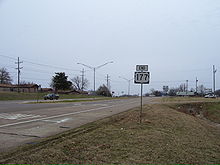 US-177's southern terminus near Madill, Oklahoma
US-177 begins concurrent with State Highway 199 at the US-70 junction near Madill, Oklahoma. From this point, it heads northwest, serving as the southern terminus of State Highway 1 and the main street of Mannsville. The route turns northward in Dickson, where it splits from SH-199. East of Gene Autry, it is the eastern end of SH-53. US-177 then runs through the Chickasaw National Recreation Area and the town of Sulphur, where it has a brief concurrency with SH-7. On the north side of Sulphur lies a partial interchange with the Chickasaw Turnpike.
US-177 continues north into western Garvin County, serving as the eastern terminus of SH-29 and crossing SH-19 in Stratford. The route then cuts across the narrow eastern tip of McClain County, where it begins concurrencies with both State Highway 59 and State Highway 3W. The three highways then cross the Canadian River into Pottawatomie County, where they meet SH-39 at a four-way stop in Asher.
Near unincorporated Pearson, SH-59 splits off to the east. US-177/SH-3W continue north to Tecumseh, where they have an interchange with SH-9. At this interchange, US-270 joins the concurrency. The three highways run along the west side of Shawnee. At the Interstate 40 interchange, SH-3W reunites with SH-3E, and the unified SH-3 (along with US-270) follows I-40. US-177 continues northward alone.
After crossing into Lincoln County, US-177 meets US-62 in Jacktown. Just west of Warwick, it meets SH-66 (old Route 66), and then passes under Interstate 44 (the Turner Turnpike), with no interchange. I-44 is accessed through the SH-66 – Wellston (Exit 157) interchange. US-177 then continues north, connecting to the town of Carney via SH-40A, the shortest state highway in Oklahoma. West of Tryon, it intersects State Highway 105. It then enters Payne County just south of the Cimarron River.
In Payne County, US-177 almost immediately passes through the town of Perkins. North of that community, it has a one-mile (1.6 km) concurrency with State Highway 33. It then passes through the county seat, Stillwater, the home of Oklahoma State University. There, it intersects SH-51. North of Stillwater, it serves as the western terminus of the Cimarron Turnpike Spur. Farther north, in Noble County, it crosses U.S. Highway 64 and the mainline of the Cimarron Turnpike. It then has a four mile (6.4 km) concurrency with State Highway 15.
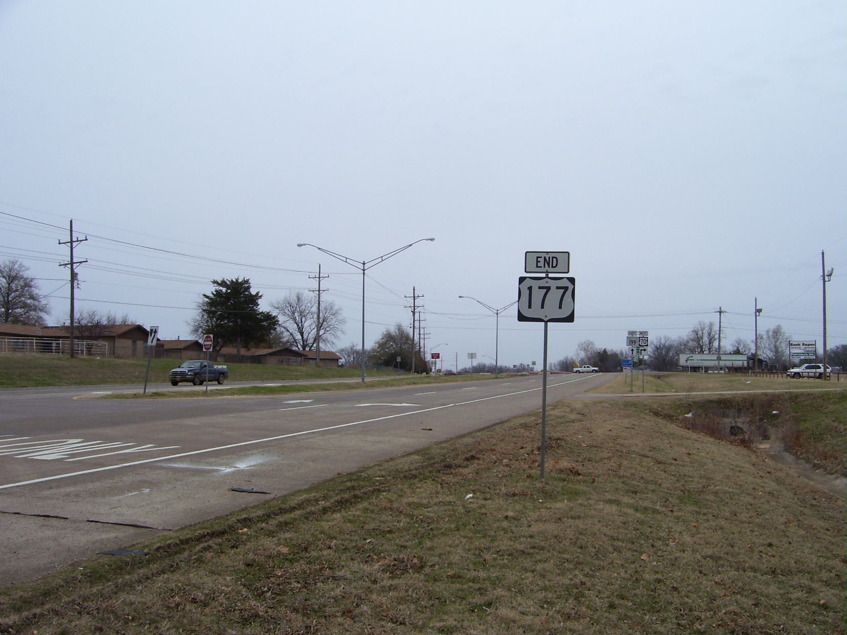
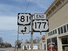 US-177's northern terminus in South Haven, Kansas
US-177 then enters its final county in Oklahoma, Kay County. It serves Ponca City, where it begins a wrong-way concurrency with its parent, US-77, as well as US-60 (which is signed the "correct" direction). The routes split near Tonkawa. US-177 then runs through Blackwell and Braman. North of Braman, the route is the northernmost exit on Interstate 35 in Oklahoma. Six miles (9.7 km) after the I-35 junction, US-177 leaves Oklahoma.
US-177 then enters Sumner County, Kansas near Hunnewell. Only 4 mi (6.4 km) north of the state line, US-177 ends at US-81 in downtown South Haven, Kansas. The terminus is less than a mile from the western terminus of U.S. Route 166 (also on US-81) north of town.
History
Originally, the highway functioned as a shortcut for Wichita to Oklahoma City traffic traveling between U.S. 81 at South Haven, KS and U.S. 77 at Three Sands Jct, Oklahoma (where U.S. 77 and State Highway 156 intersect outside Marland, Oklahoma today).
During the 1960s, the highway was extended south to Madill, Oklahoma, replacing the entire length of State Highway 40 from Ponca City, Oklahoma to then-U.S. Highway 66 (near Wellston, Oklahoma) and the portion of State Highway 18 between Shawnee, Oklahoma and Madill, Oklahoma (the segment between US-66 and Shawnee was constructed at this time). Vestiages of the these highways remain in spur routes State Highway 40A, located entirely in Carney, Oklahoma and State Highway 18A, located south of Sulphur, Oklahoma.
During this extension, the alignments of US-77 and US-177 were altered in North Central Oklahoma as follows:
US-77 was relocated to run north from Three Sands Jct to Tonkawa, Oklahoma on the former route of US-177, then east on US-60 to Ponca City, Oklahoma. This also involved a new US-60 alignment between Tonkawa, Oklahoma and Ponca City, Oklahoma, where US-60, US-77, and US-177 all overlap on the same highway (which results in northbound US-77, eastbound US-60, and southbound U.S. Highway 177 traffic running in the same compass direction - east).
Junction list
Oklahoma
County Location Mile[2] Destinations Notes Marshall Madill 0.0 US-70Southern terminus; concurrent with SH-199 Johnston 6.1  SH-1
SH-1Southern terminus of SH-1 Carter Dickson 15.2 SH-19922.5  SH-53
SH-53Eastern terminus of SH-53 Murray Chickasaw NRA  SH-18A
Western terminus of SH-18A Sulphur 38.1  SH-7
SH-738.4 SH-740.6 Chickasaw Turnpike Partial interchange Garvin 48.1  SH-29
SH-29Eastern terminus of SH-29 Stratford 58.2  SH-19
SH-19McClain 64.3  SH-59
SH-5964.3  SH-59A
Western terminus of SH-59A 69.4  SH-3W
SH-3WPottawatomie Asher 72.0  SH-39
SH-39Pearson 78.1 SH-59Chisney 78.1  SH-59B
Eastern terminus of SH-59B Tecumseh 91.1 
 US-270/SH-9
Interchange, SH-9 does not concur Shawnee 95.5 

 US-270 BUS/SH-18
Interchange, southern terminus of SH-18 97.1
US-270 BUSInterchange 101.0 

I-40 does not concur; SH-3 splits into SH-3E and SH-3W, only SH-3W concurs 102.0  SH-270
Eastern terminus of SH-270 Lincoln Jacktown 110.0  US-62
US-62Warwick 122.4  SH-66
SH-66Carney 131.2[3]  SH-40A
Western terminus of SH-40A 135.5  SH-105
Payne Perkins 144.0  SH-33
SH-33145.0 SH-33Stillwater 154.1  SH-51
SH-51159.7 Cimarron Turnpike Spur Western terminus of Cimarron Turnpike Spur Noble 166.4  US-64
US-64172.8  US-412/Cimarron Turnpike
174.3  SH-15
SH-15178.4 SH-15Kay Ponca City 193.5 
 US-60/77
196.4
US-60 BUSWestern terminus of US-60 BUS 197.1 
Northern terminus of SH-156 Tonkawa 204.9 US-60/77Blackwell 213.6  SH-11
SH-11Braman 223.9  I-35
I-35Kansas
County Location Mile[4] Destinations Notes Sumner South Haven 3.5 US-81Northern terminus 1.000 mi = 1.609 km; 1.000 km = 0.621 mi
Concurrency terminus • Closed/Former • Incomplete access • UnopenedState Highway 40A
State Highway 40A
Location: Carney, Oklahoma Length: 0.35 mi[5] (0.56 km) State Highway 40A is an 0.35-mile (0.56 km)[5] highway in Lincoln County, Oklahoma. It is numbered after State Highway 40, the predecessor to US-177. It is the shortest state highway in Oklahoma.
The highway connects US-177 to the town of Carney, Oklahoma. It has a 25 mph (40 km/h) speed limit.
See also
Related routes
References
- ^ Droz, Robert V. U.S. Highways : From US 1 to (US 830). URL accessed 22:46, 20 February 2006 (UTC).
- ^ Stuve, Eric. "U.S. 177". OKHighways. http://www.okhighways.com/us177.html. Retrieved 2007-11-24.
- ^ Google, Inc. Google Maps – U.S. Route 177 (Map). Cartography by Google, Inc. http://maps.google.com/maps?f=d&hl=en&geocode=2184714061627395074,35.681020,-97.017240%3B13799777163803555865,35.690346,-97.017260&time=&date=&ttype=&saddr=US-177+%4035.681020,+-97.017240&daddr=US-177+%4035.690346,+-97.017260+to:35.809409,-97.018075&mra=mi&mrcr=1&mrsp=2&sz=17&sll=35.809922,-97.016809&sspn=0.003881,0.006716&ie=UTF8&ll=35.810392,-97.016605&spn=0.00388,0.006716&z=17&om=1. Retrieved 2007-11-24.
- ^ Google, Inc. Google Maps – U.S. Route 177 (Map). Cartography by Google, Inc. http://maps.google.com/maps?f=d&hl=en&geocode=16559528374337224714,36.998750,-97.400300&time=&date=&ttype=&saddr=US-177+%4036.998750,+-97.400300&daddr=37.04959,-97.40118&mra=mi&mrsp=1,0&sz=18&sll=37.049731,-97.40066&sspn=0.00191,0.003358&ie=UTF8&ll=37.024621,-97.392597&spn=0.061125,0.10746&z=13&om=1. Retrieved 2007-11-24.
- ^ a b Oklahoma Department of Transportation. 2008 Control Section Maps (Map). p. Lincoln. http://www.odot.org/hqdiv/p-r-div/maps/control-maps/Lincoln.pdf. Retrieved 2010-03-16.
Browse numbered routes ←  SH-171
OK US-183  →
→←  K-175
K-175KS K-177  →Categories:
- Three-digit U.S. Highways
- U.S. Highways in Kansas
- U.S. Highways in Oklahoma


Wikimedia Foundation. 2010.