- National Register of Historic Places listings in Minnehaha County, South Dakota
-
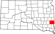
 Location of Minnehaha County in South Dakota
This is a list of the National Register of Historic Places listings in Minnehaha County, South Dakota.
This is intended to be a complete list of the properties and districts on the National Register of Historic Places in Minnehaha County, South Dakota, United States. The locations of National Register properties and districts for which the latitude and longitude coordinates are included below, may be seen in a Google map.[1]
There are 95 properties and districts listed on the National Register in the county. Three other properties were once listed but have been removed.
-
- This National Park Service list is complete through NPS recent listings posted November 10, 2011.[2]
Current listings
[3] Landmark name [4] Image Date listed Location City or town Summary 1 All Saints Historic District 
February 23, 1984 Roughly Main to 2nd Ave. from 14th to 23rd Sts., and 18th to 21st Sts. to 5th Ave.
43°32′11″N 96°43′30″W / 43.536389°N 96.725°WSioux Falls 2 All Saints School Main Building 
March 14, 1973 101 W. 17th St.
43°32′14″N 96°43′40″W / 43.537222°N 96.727778°WSioux Falls 3 Augustana College Historic Buildings 
March 25, 1977 29th and S. Summit Sts.
43°31′34″N 96°44′12″W / 43.526111°N 96.736667°WSioux Falls 4 Austin-Olson Farm December 14, 1995 24993 465th Ave.
43°45′46″N 96°54′42″W / 43.762778°N 96.911667°WColton 5 Berdahl-Rolvaag House 
January 23, 1979 1009 W. 33rd St.
43°31′14″N 96°44′21″W / 43.520556°N 96.739167°WSioux Falls 6 Berg and Estensen Store 
November 8, 2001 110 Zeliff Ave.
43°45′29″N 96°28′33″W / 43.758056°N 96.475833°WSherman 7 Marion E. Bowen House 
May 28, 1976 840 W. 9th St.
43°32′50″N 96°44′16″W / 43.547222°N 96.737778°WSioux Falls 8 Brandon Village June 14, 2001 Address Restricted Brandon 9 Bridge at Iverson Crossing 
July 17, 1996 48054 266th St.
43°31′44″N 96°36′02″W / 43.528889°N 96.600556°WBrandon 10 Brooks Brothers Home 
October 24, 1996 1006-1008 South Dakota Ave.
43°32′10″N 96°43′45″W / 43.536111°N 96.729167°WSioux Falls 11 Building at 529 North Main 
January 14, 2005 529 N. Main Ave.
43°43′04″N 96°30′11″W / 43.717778°N 96.503056°WGarretson 12 Gina Smith Campbell Bathhouse 
February 13, 1986 City Park, Beach Ave. extension
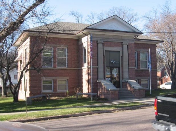
43°49′12″N 96°42′06″W / 43.82°N 96.701667°WDell Rapids 13 Carnegie Free Public Library 
March 14, 1973 235 W. 10th St.
43°49′30″N 96°42′36″W / 43.825°N 96.71°WSioux Falls 14 Carnegie Public Library 
February 13, 1986 513 N. Orleans
43°49′30″N 96°42′36″W / 43.825°N 96.71°WDell Rapids 15 Carpenter Hotel 
August 13, 1986 221 S. Phillips Ave.
43°32′43″N 96°43′36″W / 43.545278°N 96.726667°WSioux Falls 16 Cathedral Historic District 
June 5, 1974 Bounded by W. 4th and 10th Sts., Spring, Prairie, and Summit Aves.
43°33′00″N 96°44′06″W / 43.55°N 96.735°WSioux Falls Known as the Sioux Falls Historic District until 2011 17 Central Fire Station 
May 27, 1980 100 S. Minnesota Ave.
43°32′49″N 96°43′51″W / 43.546944°N 96.730833°WSioux Falls 18 Cherry Rock Park Bridge 
May 30, 2003 Cherry Rock Park
43°32′16″N 96°42′17″W / 43.537778°N 96.704722°WSioux Falls 19 Edward Coughran House 
May 28, 1976 1203 S. 1st Ave.
43°32′04″N 96°43′31″W / 43.534444°N 96.725278°WSioux Falls 20 E.J. and Alice Daniels House 
October 19, 1989 3901 S. Hawthorne
43°30′34″N 96°44′56″W / 43.509444°N 96.748889°WSioux Falls 21 Dell Rapids Amphitheater 
February 15, 2002 City park
43°49′15″N 96°42′11″W / 43.820833°N 96.703056°WDell Rapids 22 Dell Rapids Bridge 
August 5, 1999 Local road over the Big Sioux River
43°49′12″N 96°42′35″W / 43.82°N 96.709722°WDell Rapids Also known as the South Dakota Department of Transportation Bridge 50-210-01 23 Dell Rapids Bridge January 28, 2000 Local road over the Big Sioux River
43°49′12″N 96°42′35″W / 43.82°N 96.709722°WDell Rapids Also known as the South Dakota Department of Transportation Bridge 50-210-018 24 Dell Rapids Historic District 
February 23, 1978 335-536 E. 4th St.
43°49′24″N 96°42′36″W / 43.823333°N 96.71°WDell Rapids 25 Dell Rapids Residential Historic District 
October 12, 2000 Roughly bounded by Orleans Ave., 4th St., and 7th St.
43°49′30″N 96°42′17″W / 43.825°N 96.704722°WDell Rapids 26 Dell Rapids Water Tower 
February 23, 1984 10th and Orleans
43°49′47″N 96°42′32″W / 43.829722°N 96.708889°WDell Rapids 27 Harrison DeLong House 
October 12, 2000 621 S. Main
43°32′27″N 96°43′41″W / 43.540833°N 96.728056°WSioux Falls 28 Eighth Street Bridge 
December 9, 1993 S. 8th St. over the Big Sioux River
43°32′55″N 96°43′31″W / 43.548611°N 96.725278°WSioux Falls 29 Farley-Loetscher Company Building 
January 26, 2001 701-705 E. 8th St.
43°32′54″N 96°43′05″W / 43.548333°N 96.718056°WSioux Falls 30 Farley-Loetscher Company Building I 
February 5, 2003 322 and 324 E. 8th St.
43°32′55″N 96°43′51″W / 43.548611°N 96.730833°WSioux Falls 31 Federal Building and U.S. Courthouse 
May 2, 1974 400 S. Phillips Ave.
43°32′36″N 96°43′33″W / 43.543333°N 96.725833°WSioux Falls 32 First Congregational Church 
August 18, 1983 303 S. Dakota Ave.
43°32′40″N 96°43′48″W / 43.544444°N 96.73°WSioux Falls 33 First National Bank of Garretson November 2, 2011 605 Main St.
43°42′59″N 96°30′10″W / 43.716389°N 96.502778°WGarretson 34 Josephine Martin Glidden Memorial Chapel 
September 25, 1987 2121 E. 12th St.
43°32′37″N 96°41′58″W / 43.543611°N 96.699444°WSioux Falls 35 Glidden-Martin Hall 
November 8, 2000 1101 W. 22nd Ave.
43°31′58″N 96°44′19″W / 43.532778°N 96.738611°WSioux Falls 36 The Gloria House 
July 20, 2000 1216 S. Center Ave.
43°32′03″N 96°43′42″W / 43.534167°N 96.728333°WSioux Falls 37 Grand Lodge and Library of the Ancient Free and Accepted Masons 
May 28, 1976 415 S. Main Ave.
43°32′34″N 96°43′42″W / 43.542778°N 96.728333°WSioux Falls 38 Hayes Historic District 
February 14, 2006 Roughly bounded by W. 22nd St. to W. 26th St. and by South Dakota Ave. to S. Phillips Ave.
43°32′04″N 96°43′43″W / 43.534444°N 96.728611°WSioux Falls 39 Orlan A. Hayward House 
December 2, 1998 1509 S. Glendale
43°32′27″N 96°44′42″W / 43.540833°N 96.745°WSioux Falls 40 Hans J. Hilmoe Barn June 28, 2010 47170 Homestead St.
43°46′06″N 96°46′35″W / 43.768333°N 96.776389°WBaltic vicinity Built in 1911 by Norwegian immigrants[5] 41 Andrew O. Huseboe House 
July 13, 1988 223 S. Prairie Ave.
43°32′44″N 96°44′14″W / 43.545556°N 96.737222°WSioux Falls 42 Illinois Central Passenger Depot 
August 18, 1983 Big Sioux River at 8th St.
43°32′58″N 96°43′24″W / 43.549444°N 96.723333°WSioux Falls 43 Jorden Hall 
November 8, 2000 1101 W. 22nd St.
43°31′56″N 96°44′19″W / 43.532222°N 96.738611°WSioux Falls 44 Andrew Kuehn Warehouse 
February 25, 1982 401 N. Phillips Ave.
43°33′05″N 96°43′37″W / 43.551389°N 96.726944°WSioux Falls 45 L & A Baking Company 
November 20, 2007 910 N. Main Ave.
43°33′29″N 96°43′39″W / 43.558056°N 96.7275°WSioux Falls 46 LaSalle Apartments 
September 14, 1998 703 S. Summit
43°32′38″N 96°44′09″W / 43.543889°N 96.735833°WSioux Falls 47 Daniel Lund House 
February 18, 2000 628 W. 20th
43°32′07″N 96°43′59″W / 43.535278°N 96.733056°WSioux Falls 48 McKennan Park Historic District 
June 6, 1984 McKennan Park, 2nd and 4th Aves. from 21st to 26th Sts., and 21st St. from Phillips to 7th Aves.; also roughly bounded by 1st Ave., S., Phillips Ave., 24th St., E., and 26th St.
43°31′56″N 96°43′17″W / 43.532222°N 96.721389°WSioux Falls Second set of boundaries represents a boundary increase 49 L.D. Miller Funeral Home 
August 18, 1983 507 S. Main Ave.
43°32′33″N 96°43′42″W / 43.5425°N 96.728333°WSioux Falls 50 William G. Milne House 
December 1, 1994 508 E. 9th St.
43°49′42″N 96°42′30″W / 43.828333°N 96.708333°WDell Rapids 51 John Mundt Building 
February 17, 1981 103 N. Main Ave.
43°37′20″N 96°56′44″W / 43.622222°N 96.945556°WHartford 52 Old Courthouse and Warehouse Historic District 
August 18, 1983 Roughly bounded by the Big Sioux River, 4th and 6th Sts., and Dakota Ave.; also roughly bounded by North Dakota Ave., 4th St., the Big Sioux River, and 7th St.
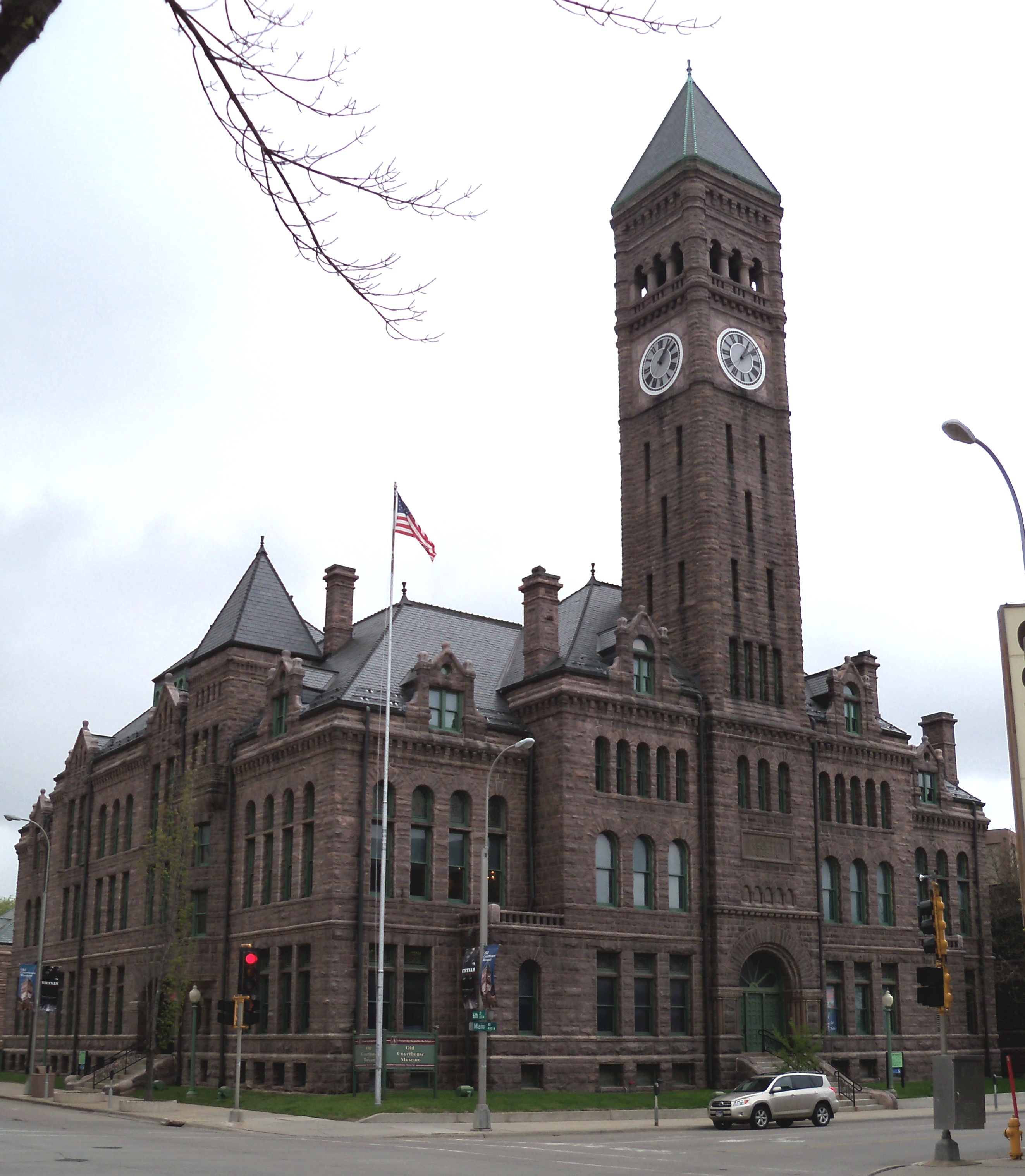
43°33′06″N 96°43′37″W / 43.551667°N 96.726944°WSioux Falls Second set of boundaries represents a boundary increase 53 Old Minnehaha County Courthouse 
May 10, 1973 Main Ave. at 6th St.
43°33′06″N 96°43′43″W / 43.551667°N 96.728611°WSioux Falls 54 Old Yankton Bridge 
August 5, 1999 Old Yankton Rd. over the Big Sioux River
43°30′05″N 96°45′03″W / 43.501389°N 96.750833°WSioux Falls 55 Orpheum Theatre 
June 23, 1983 315 N. Phillips Ave.
43°33′03″N 96°43′37″W / 43.550833°N 96.726944°WSioux Falls 56 Palisades Bridge 
June 3, 1999 25495 485th Ave.
43°41′20″N 96°31′05″W / 43.688889°N 96.518056°WGarretson 57 Parmley-Pankow House 
January 28, 2004 613 S. Main
43°32′27″N 96°43′41″W / 43.540833°N 96.728056°WSioux Falls 58 R.F. Pettigrew and S.L. Tate Building 
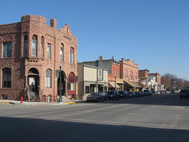
November 6, 1986 121-123 S. Main Ave.
43°33′01″N 96°43′39″W / 43.550278°N 96.7275°WSioux Falls 59 Phillips Block 
January 18, 1978 333-335 N. Main Ave.
43°33′03″N 96°43′43″W / 43.550833°N 96.728611°WSioux Falls 60 Plumbing Supply Company 
January 14, 2005 326 E. 8th St.
43°33′03″N 96°43′24″W / 43.550833°N 96.723333°WSioux Falls 61 Presentation Children's Home 
February 10, 1993 701 S. Western Ave.
43°32′23″N 96°45′04″W / 43.539722°N 96.751111°WSioux Falls 62 Queen Bee Mill 
August 1, 1984 N. Weber Ave., Falls Park
43°33′25″N 96°43′19″W / 43.556944°N 96.721944°WSioux Falls 63 Dr. Fredrich A. Randolph Block 
March 17, 1994 320 N. Main
43°33′11″N 96°43′59″W / 43.553056°N 96.733056°WSioux Falls 64 Renner Ball Park November 8, 2006 ¾ mile west of the intersection of 258th St. and Highway 115
43°38′49″N 96°43′38″W / 43.646944°N 96.727222°WRenner 65 Renner Lutheran Sanctuary 
May 7, 1980 West of South Dakota Highway 115
43°38′44″N 96°42′58″W / 43.645556°N 96.716111°WRenner 66 Grant J. Reynolds House 
December 2, 1998 800 S. Hawthorne St.
43°32′10″N 96°44′47″W / 43.536111°N 96.746389°WSioux Falls 67 Rock Island Depot 
February 15, 1974 201 E. 10th St.
43°32′45″N 96°43′29″W / 43.545833°N 96.724722°WSioux Falls 68 Security Bank Building 
February 23, 1984 101 S. Main Ave.
43°32′50″N 96°43′42″W / 43.547222°N 96.728333°WSioux Falls 69 Shafer Round Barn 
December 14, 1995 1600 S. Powder House Rd.
43°32′31″N 96°38′58″W / 43.541944°N 96.649444°WSioux Falls 70 Sherman Historic District 
January 28, 2004 Roughly bounded by W. 18th St. to W. 22nd St., and S. Dakota Ave. to S. Main St.
43°32′05″N 96°43′43″W / 43.534722°N 96.728611°WSioux Falls 71 Shriver-Johnson Building 
June 17, 1982 230 S. Phillips Ave.
43°32′41″N 96°43′34″W / 43.544722°N 96.726111°WSioux Falls 72 Sioux Falls Downtown Historic District 
December 1, 1994 Roughly bounded by S. Dakota and S. 1st Aves., W. 9th and W. 14th Sts.
43°32′49″N 96°43′43″W / 43.546944°N 96.728611°WSioux Falls 73 Sioux Falls Light and Power Hydro Electric Plant 
February 3, 1993 N. Weber Ave. on the eastern bank of the Big Sioux River
43°33′25″N 96°43′15″W / 43.556944°N 96.720833°WSioux Falls 74 Sioux Falls National Bank Building 
March 26, 1979 100 N. Phillips Ave.
43°32′51″N 96°43′35″W / 43.5475°N 96.726389°WSioux Falls 75 Slip Up Creek Homestead August 15, 2003 25359 478th Ave.
43°42′42″N 96°39′10″W / 43.711667°N 96.652778°WGarretson 76 South Dakota Department of Transportation Bridge No. 50-122-155 January 28, 2000 Local road over Skunk Creek
43°37′25″N 96°53′08″W / 43.623611°N 96.885556°WBrandon Township 77 South Dakota Department of Transportation Bridge No. 50-193-086 January 14, 2000 Local road over the Big Sioux River near Midway
43°43′12″N 96°44′54″W / 43.72°N 96.748333°WSverdrup Township 78 South Dakota Dept. of Trans. Bridge No. 50-196-104 February 10, 2000 Local road over the Big Sioux River
43°41′45″N 96°44′15″W / 43.695833°N 96.7375°WSverdrup Township 79 South Dakota School for the Deaf 
June 14, 1981 1800 E. 10th St.
43°32′51″N 96°42′10″W / 43.5475°N 96.702778°WSioux Falls 80 South Dakota State Penitentiary Historic Buildings 
April 20, 1978 1600 North Dr.
43°34′03″N 96°43′29″W / 43.5675°N 96.724722°WSioux Falls 81 South Side Fire Station No. 3 
February 23, 1984 1324 S. Minnesota Ave.
43°32′00″N 96°43′51″W / 43.533333°N 96.730833°WSioux Falls 82 Split Rock Creek Park Historic District 
July 20, 2000 Roughly 1 mile north of Garretson in Split Rock Park
43°43′14″N 96°30′07″W / 43.720556°N 96.501944°WGarretson 83 Split Rock Park Bridge 
December 9, 1993 Split Rock Park Rd. over Devils Creek Gulch
43°43′20″N 96°30′02″W / 43.722222°N 96.500556°WGarretson 84 R.D. and Mary Springer House 
December 13, 1995 201 W. 19th St.
43°32′09″N 96°43′37″W / 43.535833°N 96.726944°WSioux Falls 85 St. Peter's Lutheran Church 
February 15, 2002 701 North Orleans
43°49′34″N 96°42′37″W / 43.826111°N 96.710278°WDell Rapids 86 Dr. Steven's House 
October 31, 2002 21 S. Riverview Heights
43°31′59″N 96°45′27″W / 43.533056°N 96.7575°WSioux Falls 87 Stock Yards State Bank and Tri-State Wholesale Grocery Co. 
January 28, 2004 201/207/211 N. Weber Ave.
43°32′55″N 96°43′11″W / 43.548611°N 96.719722°WSioux Falls 88 Charles A. Thomas House 
October 31, 1985 620 S. Dakota Ave.
43°32′27″N 96°43′43″W / 43.540833°N 96.728611°WSioux Falls 89 Thompson Farmstead February 18, 1999 47339 248th St.
43°47′03″N 96°44′27″W / 43.784167°N 96.740833°WDell Rapids 90 Tolefsons Beef Stock Farm February 14, 2002 24450 458th Ave.
43°50′36″N 97°02′39″W / 43.843333°N 97.044167°WColton 91 John W. Tuthill Lumber Company 
August 24, 2006 311 E. 8th St.
43°33′01″N 96°43′24″W / 43.550278°N 96.723333°WSioux Falls 92 Washington High School 
February 13, 1986 315 S. Main
43°32′38″N 96°43′43″W / 43.543889°N 96.728611°WSioux Falls 93 Laura M. Welch House 
March 7, 2000 1218 S. Willow Ave.
43°32′06″N 96°45′00″W / 43.535°N 96.75°WSioux Falls 94 Williams Piano Company House 
October 12, 2000 1019 S. Norton
43°32′09″N 96°44′06″W / 43.535833°N 96.735°WSioux Falls 95 Willow Grove Farm May 30, 2003 47480 258th Ave.
43°40′24″N 96°43′36″W / 43.673333°N 96.726667°WRenner Former listings
Landmark name Image Date Location City or Town Summary 1 Bridge No. 50-122-155-Brandon vicinity March 26, 2008 (delisted) Brandon Township 2 South Dakota Department of Transportation Bridge No. 50-192-132 March 26, 2008 (delisted) Renner 3 Summit Avenue Viaduct March 26, 2008 (delisted) Summit Ave. over the former Chicago and North Western railroad tracks
43°32′28″N 96°44′8″W / 43.54111°N 96.73556°WSioux Falls See also
- List of National Historic Landmarks in South Dakota
- National Register of Historic Places listings in South Dakota
References
- ^ The latitude and longitude information provided in this table was derived originally from the National Register Information System, which has been found to be fairly accurate for about 99% of listings. For about 1% of NRIS original coordinates, experience has shown that one or both coordinates are typos or otherwise extremely far off; some corrections may have been made. A more subtle problem causes many locations to be off by up to 150 yards, depending on location in the country: most NRIS coordinates were derived from tracing out latitude and longitudes off of USGS topographical quadrant maps created under the North American Datum of 1927, which differs from the current, highly accurate WGS84 GPS system used by Google maps. Chicago is about right, but NRIS longitudes in Washington are higher by about 4.5 seconds, and are lower by about 2.0 seconds in Maine. Latitudes differ by about 1.0 second in Florida. Some locations in this table may have been corrected to current GPS standards.
- ^ "National Register of Historic Places: Weekly List Actions". National Park Service, United States Department of the Interior. Retrieved on November 10, 2011.
- ^ Numbers represent an ordering by significant words. Various colorings, defined here, differentiate National Historic Landmark sites and National Register of Historic Places Districts from other NRHP buildings, structures, sites or objects.
- ^ "National Register Information System". National Register of Historic Places. National Park Service. . http://nrhp.focus.nps.gov/natreg/docs/All_Data.html.
- ^ "Baltic barn listed on National Register". argusleader.com. Sioux Falls, South Dakota: Argus Leader. August 31, 2010. http://www.argusleader.com/article/20100831/NEWS/8310321/1003/BUSINESS. Retrieved September 2, 2010.[dead link]
U.S. National Register of Historic Places Topics Lists by states Alabama • Alaska • Arizona • Arkansas • California • Colorado • Connecticut • Delaware • Florida • Georgia • Hawaii • Idaho • Illinois • Indiana • Iowa • Kansas • Kentucky • Louisiana • Maine • Maryland • Massachusetts • Michigan • Minnesota • Mississippi • Missouri • Montana • Nebraska • Nevada • New Hampshire • New Jersey • New Mexico • New York • North Carolina • North Dakota • Ohio • Oklahoma • Oregon • Pennsylvania • Rhode Island • South Carolina • South Dakota • Tennessee • Texas • Utah • Vermont • Virginia • Washington • West Virginia • Wisconsin • WyomingLists by territories Lists by associated states Other Municipalities and communities of Minnehaha County, South Dakota Cities Baltic | Brandon | Colton | Crooks | Dell Rapids | Garretson | Hartford | Sioux Falls‡ | Valley Springs
Towns Unincorporated
communitiesFootnotes ‡This populated place also has portions in an adjacent county or counties
Categories:- Minnehaha County, South Dakota
- National Register of Historic Places in South Dakota by county
- Buildings and structures in Minnehaha County, South Dakota
-


Wikimedia Foundation. 2010.