Corson, South Dakota

Corson, South Dakota
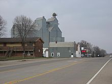
Corson, South Dakota 1.jpg

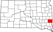
Corson is an unincorporated community in Brandon Township, Minnehaha County, United States with a population of 70. It lies immediately north of Interstate 90 and a mile north of Brandon on South Dakota Highway 11. A railroad and farming community, it is becoming an industrial area supporting the county and Sioux Falls located twelve miles to the west-southwest.

Coordinates: 43°36′59″N 96°34′18″W / 43.61639°N 96.57167°W / 43.61639; -96.57167


Wikimedia Foundation. 2010.

Игры ⚽ Поможем написать курсовую

Look at other dictionaries:

  • Corson County, South Dakota — Corson County Courthouse in McIntosh, South Dakota in 1993. This building was destroyed by fire on April 10, 2006 …   Wikipedia

  • South Dakota — Dakota du Sud South Dakota State of South Dakota Dakota du Sud …   Wikipédia en Français

  • South Dakota Supreme Court — The South Dakota Supreme Court is the highest court in the state of South Dakota. It is composed of a chief justice and four associate justices appointed by governor and selected from five different appointment districts. Justices face a… …   Wikipedia

  • South Dakota — This article is about the U.S. state of South Dakota. For other uses, see South Dakota (disambiguation). State of South Dakota …   Wikipedia

  • South Dakota Highway 20 — Infobox road state=SD marker highway name=Highway 20 length mi=432 established=1929 decommissioned= direction a=West starting terminus=Montana border west of Camp Crook direction b=East ending terminus= east of Revillo cities=Buffalo, Bison,… …   Wikipedia

  • South Dakota Highway 65 — Infobox road state=SD marker highway name=Highway 65 length mi=68 established=1926 decommissioned= direction a=South starting terminus= east of Dupree direction b=North ending terminus= McIntosh cities=McIntosh previous type=SD previous route=63… …   Wikipedia

  • South Dakota Highway 73 — Infobox road state=SD marker highway name=Highway 73 length mi=250 established=1926 decommissioned= direction a=South starting terminus= Nebraska border direction b=North ending terminus= Thunder Hawk cities=Martin, Philip, Faith, Lemmon previous …   Wikipedia

  • South Dakota Highway 11 — Infobox road state=SD marker highway name=Highway 11 length mi=80 established=1929 decommissioned= direction a=South starting terminus= at Elk Point direction b=North ending terminus= west of Jasper, MN cities=Elk Point, Alcester, Sioux Falls,… …   Wikipedia

  • McIntosh, South Dakota —   City   Locati …   Wikipedia

  • McLaughlin, South Dakota —   City   Main Street in McLaughlin Nickname(s): Home of the Midget …   Wikipedia

Share the article and excerpts

Direct link
Do a right-click on the link above
and select “Copy Link”