- National Register of Historic Places listings in Frederick County, Virginia
-
This list includes properties and districts listed on the National Register of Historic Places in Frederick County, Virginia. Click the "Map of all coordinates" link to the right to view a Google map of all properties and districts with latitude and longitude coordinates in the table below.[1]
-
- This National Park Service list is complete through NPS recent listings posted November 10, 2011.[2]
[3] Landmark name [4] Image Date listed Location City or town Summary 1 Willa Cather Birthplace November 16, 1978 NW of Gore on U.S. 50
39°16′03″N 78°19′27″W / 39.2675°N 78.324167°WGore 2 Belle Grove Plantation 
August 11, 1969 On I-81 between Middletown and Strasburg
39°00′44″N 78°18′16″W / 39.012222°N 78.304444°WMiddletown 3 Crumley-Lynn-Lodge House September 6, 2006 3641 Apple Pie Ridge Rd.
39°18′15″N 78°08′32″W / 39.304167°N 78.142222°WWinchester 4 Fort Collier April 28, 2006 One mile N of Winchester on VA 11
39°12′11″N 78°09′14″W / 39.203056°N 78.153889°WWinchester 5 Fort Colvin May 8, 2007 104 Stonebrook Rd.
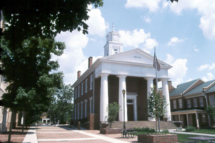
39°08′26″N 78°13′31″W / 39.140556°N 78.225278°WWinchester 6 Frederick County Courthouse 
July 5, 2001 20 N. Loudoun St.
39°11′02″N 78°09′52″W / 39.183889°N 78.164444°WWinchester 7 Frederick County Poor Farm August 12, 1993 VA 654 E side, S of jct. with VA 679
39°12′44″N 78°13′24″W / 39.212222°N 78.223333°WRound Hill 8 High Banks March 1, 2011 423 High Banks Rd.
39°12′22″N 78°04′12″W / 39.206111°N 78.07°WStephenson vicinity 9 John Hite House July 8, 1982 US 11
39°06′32″N 78°12′11″W / 39.108889°N 78.203056°WBartonsville 10 Homespun December 31, 2002 949 Cedar Creek Grade
39°09′55″N 78°11′36″W / 39.165278°N 78.193333°WWinchester 11 Hopewell Friends Meetinghouse March 28, 1980 W of Clear Brook off VA 672
39°15′23″N 78°06′55″W / 39.256389°N 78.115278°WClear Brook 12 Long Meadow July 27, 2005 1946 Jones Rd.
39°09′10″N 78°13′37″W / 39.152778°N 78.226944°WWinchester 13 Middletown Historic District June 23, 2003 Bounded by Main St., Church St., Senseney Av., 1st, 4th, 6th & 3rd Sts.
39°01′42″N 78°16′47″W / 39.028333°N 78.279722°WMiddletown 14 Monte Vista November 16, 1987 8100 US 11
39°01′12″N 78°17′22″W / 39.02°N 78.289444°WMiddletown 15 Newtown-Stephensburg Historic District 
August 18, 1992 Roughly, Main St. from city limit to Farm View Dr. and adjacent areas of Mulberry and German Sts.
39°05′02″N 78°13′06″W / 39.083889°N 78.218333°WStephens City 16 Old Forge Farm February 11, 2004 7326 Middle rd.
39°04′41″N 78°19′33″W / 39.078056°N 78.325833°WMiddletown 17 Old Stone Church July 5, 2001 Approx. 1 mi. W of jct. of VA 671 and VA 739
39°18′04″N 78°10′05″W / 39.301111°N 78.168056°WWhite Hall 18 Opequon Historic District May 16, 2002 Jct. of VA 622 and VA 620
39°09′26″N 78°14′50″W / 39.157222°N 78.247222°WWinchester 19 Opequon Presbyterian Church February 16, 2001 217 Opequon Church Ln.
39°08′20″N 78°11′43″W / 39.138889°N 78.195278°WWinchester 20 Rose Hill Farm February 21, 1997 1985 Jones Rd.
39°09′00″N 78°12′59″W / 39.15°N 78.216389°WWinchester 21 Springdale Mill Complex July 8, 1982 US 11
39°06′34″N 78°12′23″W / 39.109444°N 78.206389°WBartonsville 22 St. Thomas Chapel April 11, 1973 Jct. of SR 1102 and 1105
39°01′39″N 78°16′40″W / 39.0275°N 78.277778°WMiddletown 23 Sunrise February 8, 1995 975 Hollow Rd.
39°15′52″N 78°22′29″W / 39.264444°N 78.374722°WGore 24 Valley Mill Farm February 9, 2006 1494 Valley Mill Rd.
39°10′41″N 78°05′19″W / 39.178056°N 78.088611°WWinchester 25 Willow Shade December 18, 1990 Jct. of Frederick Co. Rd. and US 50
39°15′46″N 78°18′06″W / 39.262778°N 78.301667°WWinchester See also
- National Register of Historic Places listings in Virginia
- National Register of Historic Places listings in Winchester, Virginia
- List of National Historic Landmarks in Virginia
References
- ^ The latitude and longitude information provided in this table was derived originally from the National Register Information System, which has been found to be fairly accurate for about 99% of listings. For about 1% of NRIS original coordinates, experience has shown that one or both coordinates are typos or otherwise extremely far off; some corrections may have been made. A more subtle problem causes many locations to be off by up to 150 yards, depending on location in the country: most NRIS coordinates were derived from tracing out latitude and longitudes off of USGS topographical quadrant maps created under the North American Datum of 1927, which differs from the current, highly accurate WGS84 GPS system used by Google maps. Chicago is about right, but NRIS longitudes in Washington are higher by about 4.5 seconds, and are lower by about 2.0 seconds in Maine. Latitudes differ by about 1.0 second in Florida. Some locations in this table may have been corrected to current GPS standards.
- ^ "National Register of Historic Places: Weekly List Actions". National Park Service, United States Department of the Interior. Retrieved on November 10, 2011.
- ^ Numbers represent an ordering by significant words. Various colorings, defined here, differentiate National Historic Landmark sites and National Register of Historic Places Districts from other NRHP buildings, structures, sites or objects.
- ^ "National Register Information System". National Register of Historic Places. National Park Service. . http://nrhp.focus.nps.gov/natreg/docs/All_Data.html.
U.S. National Register of Historic Places Topics Lists by states Alabama • Alaska • Arizona • Arkansas • California • Colorado • Connecticut • Delaware • Florida • Georgia • Hawaii • Idaho • Illinois • Indiana • Iowa • Kansas • Kentucky • Louisiana • Maine • Maryland • Massachusetts • Michigan • Minnesota • Mississippi • Missouri • Montana • Nebraska • Nevada • New Hampshire • New Jersey • New Mexico • New York • North Carolina • North Dakota • Ohio • Oklahoma • Oregon • Pennsylvania • Rhode Island • South Carolina • South Dakota • Tennessee • Texas • Utah • Vermont • Virginia • Washington • West Virginia • Wisconsin • WyomingLists by territories Lists by associated states Other Municipalities and communities of Frederick County, Virginia Towns 
CDPs Unincorporated
communitiesAlbin | Armel | Bartonsville | Brucetown | Burnt Factory | Canterburg | Cedar Grove | Cedar Hill | Clear Brook | Cross Junction | De Haven | Gainesboro | Gore | Gravel Springs | Green Spring | Grimes | Hayfield | Indian Hollow | Jordan Springs | Kernstown | Klines Mill | Leetown | Marlboro | McQuire | Meadow Mills | Mount Pleasant | Mount Williams | Mountain Falls | Mountain Falls Park | Nain | Opequon | Parkins Mills | Rest | Reynolds Store | Ridings Mill | Rock Enon Springs | Round Hill | Shockeysville | Siler | Star Tannery | Stephenson | Vaucluse | Welltown | Whitacre | White Hall | Wilde Acres
Categories:- Frederick County, Virginia
- National Register of Historic Places in Virginia
- Virginia-related lists
-


Wikimedia Foundation. 2010.