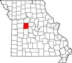
- Beaman, Missouri
-
Beaman, Missouri — Unincorporated community — Nickname(s): Show-Me-Town Coordinates: 38°45′26″N 93°8′1″W / 38.75722°N 93.13361°WCoordinates: 38°45′26″N 93°8′1″W / 38.75722°N 93.13361°W Country United States State Missouri County Pettis Elevation 817 ft (249 m) Time zone Central (CST) (UTC-6) – Summer (DST) CDT (UTC-5) ZIP code Area code(s) 660 GNIS feature ID 0729702[1] Beaman (also Marlin) is an unincorporated community in Pettis County, Missouri, United States. Its altitude is 817 feet (249 m), and it is located at 38°45′26″N 93°8′1″W / 38.75722°N 93.13361°W (38.7572390, -93.1335358).[2]
Market
Beaman's Market is the only thing left from Beaman's heyday.
Fire station
the Fire station is in the 1st and only district. the fire station has three cars at its disposal, a Fire Truck, a water tuck, and a pick-up truck.
References
- ^ "US Board on Geographic Names". United States Geological Survey. 2007-10-25. http://geonames.usgs.gov. Retrieved 2008-01-31.
- ^ U.S. Geological Survey Geographic Names Information System: Beaman, Missouri
Municipalities and communities of Pettis County, Missouri Cities Villages Hughesville | Ionia‡
Townships Blackwater | Bowling Green | Cedar | Dresden | Elk Fork | Flat Creek | Green Ridge | Heath Creek | Houstonia | Hughesville | Lake Creek | La Monte | Longwood | Prairie | Sedalia | Smithton | Washington
Unincorporated
communitiesFootnotes ‡This populated place also has portions in an adjacent county or counties
Categories:- Unincorporated communities in Pettis County, Missouri
- Missouri geography stubs
Wikimedia Foundation. 2010.


