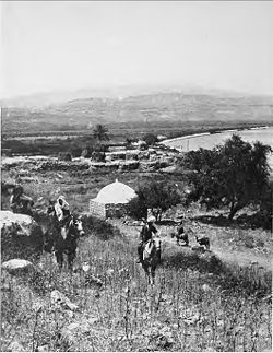
- al-Majdal, Tiberias
-
al-Majdal 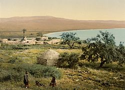
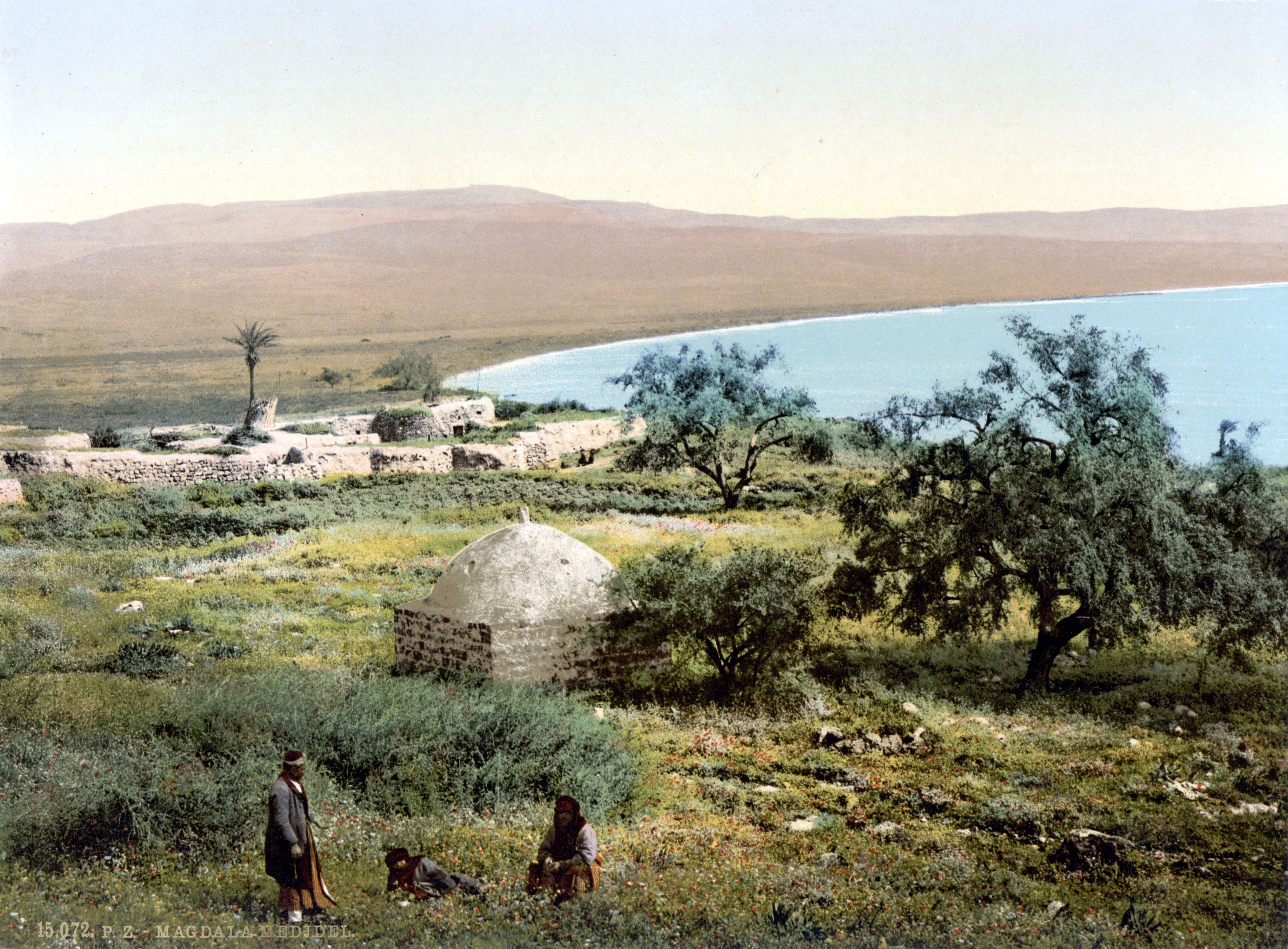
al-Majdal, sea of Galilee circa 1890/1900. Shrine of Muhammad al-'Ajami in the foreground.
 al-Majdal
Arabic المجدل Also Spelled Majdal, Magdala District Tiberias Coordinates 32°49′27.65″N 35°30′59.87″E / 32.8243472°N 35.5166306°ECoordinates: 32°49′27.65″N 35°30′59.87″E / 32.8243472°N 35.5166306°E Population 418[1] (1948) Area 103[1][2] dunums Date of depopulation 22 April 1948[3] Cause(s) of depopulation Military assault by Yishuv forces Secondary cause Influence of nearby town's fall Current localities Migdal, Israel Al-Majdal (Arabic: المجدل, "tower", also transliterated Majdal, Majdil and Mejdel) was a Palestinian Arab village located on the western shore of the Sea of Galilee (200 meters (660 ft) above sea level), 3 miles (4.8 km) north of Tiberias and south of Khan Minyeh.[1][4][5] It is identified with the site of the ancient town of Magdala, reputed to be the birthplace of Mary Magdalene.[6] Josephus recounts military battles there between his forces and those of Vespasian's army, and archaeological excavations indicate it was an important city on the Sea of Galilee around the time of the rule of Herod Antipas.
Christian pilgrims wrote of their visits to see the house and church of Mary Magdalene from the 6th century onward, but little is known about the village in the Mamluk and early Ottoman period, indicating it was likely small or uninhabited.[7][8] In the 19th century, Western travellers interested in the biblical History of ancient Israel and Judah documented their observations of Al-Majdal, generally describing it as a very small and poor Muslim village.[8] In 1910-11, Russian Zionists founded Migdal adjacent to Al-Majdal.[9] Just prior to the outbreak of the 1948 Arab-Israeli war, Al-Majdal was depopulated and then largely destroyed.[3][10] The Israeli town of Migdal has since expanded onto part of the village's former lands.[1]
Contents
Etymology
The Arabic name Majdal means "tower" and preserves the ancient place name Magdala.[11] Magdala was also known in ancient times as Migdal (Hebrew), and the Aramaic names ascribed to it are Magdala Nunaya (also, Migdal Nunnaya or Nunayah; "Tower of Fish") and Magdala Tza'baya (or Migdal Seb'iya; "Magdala of the dyers" or "Tower of Dyers").[12][13][14] It is referred to by these Aramaic names in the Babylonian Talmud (b. Pesah. 46b) and Jerusalem Talmud (y. Ta'an. 4.8.) respectively.[14] Also known in Greek as Magdala Taricheae ("Magdala of the fish salters"), likely due to the town's famed fish-curing industry, Josephus writes of it simply as Taricheae (Ant. 14.20; 20. 159; J.W. 1. 180; 2. 252).[12][14] The Magadan mentioned in Matthew 15:39 and the Dalmanutha of Mark 8:10 are likely corrupt forms of Magdal (Magdala) and Magdal Nuna (Magdala Nunaya).[14][15]
Mary Magdalene's surname as transcribed in the gospels is said to be derived from Magdala as her home and place of birth.[5] Alfred Edersheim cites the Talmud as evidence for this naming practice, which describes several Rabbis as 'Magdalene' or residents of Magdala.[5]
Majdal and Majdalani ("of Majdal") are common place names and family names in the Syrian, Israeli and the West Bank Arab populations.[16] Examples of such place names include Majdal (Askalan), Majdal Yaba, and Al-Mujaydil (depopulated Palestinian villages located in modern day Israel), Majdal Shams (a Syrian-Druze village in the Golan Heights), Majdal Bani Fadil (in the West Bank) and Majdal Anjar (in modern day Lebanon).[16][17]
History
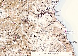 A map of the Tiberias region indicating the location of Al-Majdal published in 1880 by the Palestine Exploration Fund
Josephus writes in the 1st century CE of a Roman road that connected Magdala (Taricheae) on the Sea of Galilee to Akka (then Ptolemais), passing through Cana.[18] In his extensive accounts of the military history of Taricheae, he relates that Cassius, the governor of Syria between 53 and 51 BCE, attacked the city and took 30,000 men into slavery. During the time Josephus was the head of the Galilean revolutionaries' army (66 - c. 70 CE), he tells of fortifying the city which served as his headquarters and counting 40,000 men from within it among his supporters.[7]
Josephus also recounts imprisoning 600 members of the Roman council at Tiberias in Taricheae which served as a Zealot stronghold until it fell to Romans in 67 CE. Also recorded are the deaths of 6,700 Jews in the battle with Vespasian's army in 67 CE, and the fate of 1,200 more who had surrendered, and were then led out to the stadium in Tiberias where they were executed. Another 6,000 youths were sent away to Nero and 30,400 were sold into slavery, save those who were given as a present to Agrippa. Included in the territory of Agrippa II by Nero, following his death, it was attached to the Roman province of Judaea.[7]
Gustav Dalman writes of Magdala that, "it was the most important city on the western bank of the lake, contributing a wagon-load of taxes [...] until Herod Antipas raised up a rival on the lake by building Tiberias."[7] Magdala is also described as "the capital of a toparchy," and is compared to Sepphoris and Tiberias in that it had "administrative apparatus and personnel," though not to the same extent.[19]
Recognition of Magdala as the birthplace of Mary Magdalene appears in texts dating back to the 6th century CE.[6]
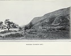 A view of Al-Majdal in 1903 when looking toward the southwest
In the 8th and 10th centuries CE, Christian sources write of a church in the village that was also Mary Magdalene's house, where Jesus is said to have exorcised her of demons.[6] The anonymously penned Life of Constantine attributes the building of the church to St Helena in the 4th century CE, at the location where she found Mary Magdalene's house.[6][19] Christian pilgrims to Palestine in the 12th century mention the location of Magdala, but fail to mention the presence of any church.[6]
Under the rule of the Mamluks in the 13th century, sources indicate that the church was not destroyed, but was transformed into a stable.[19] In 1283, Burchard of Mount Sion records having entered the house of Mary Magdalene in the village, and about ten years later, Ricoldus of Montecroce notes his joy at having found the church and house still standing. Francesco Quaresmi writes of al-Majdal in 1626 that "certain people have claimed that her house is to be seen there;" however, Denys Pringle writes that by this time the site was in ruins.[6] Part of the site was acquired by the Franciscan Custody of the Holy Land sometime after 1935.[6][20]
 Al-Majdal in 1910
The small Muslim Arab village of Al-Majdal was located to the south of the land acquired by the Franciscans.[6] Little is known about the village in the medieval or early Ottoman period, presumably because it was either small or uninhabited.[8] Fellahin from Egypt are said to have settled in the village some time in the 19th century.[20] In the early 19th century, foreign travellers interested in the Christian traditions associated with the site visited the village.[8] In 1807 U. Seetzen stayed overnight in "the little Mahommedan village of Majdil, situated on the bank of the lake."[21] The English traveler James Silk Buckingham observed in 1816 that a few Muslim families resided there, and in 1821, the Swiss traveler Johann Ludwig Burckhardt notes that the village was in a rather poor condition.[1][22][23] Edward Robinson also writes of Al-Majdal during his travels through Syria and Palestine in 1838. Transcribing its name as el-Mejdel, he describes it as "a miserable little Muslim village, looking much like a ruin, though exhibiting no marks of antiquity." Robinson was nevertheless aware of the village's ancient associations:
"The name Mejdel, is obviously the same with the Hebrew Migdal and Greek Magdala; there is little reason to doubt that this place is the Magdala of the New Testament, chiefly known as the native town of Mary Magdalene. The ancient notices respecting its position are exceedingly indefinite; yet it seems to follow from the New Testament itself, that it lay on the west side of the lake. After the miraculous feeding of four thousand, which appears to have taken place in the country east of the lake, Jesus 'took ship and came into the coast of Magdala;' for which Mark the Evangelist writes Dalmanutha. Here, the Pharisees began to question him, but he 'left them, and entering into the ship again, departed to the other side [...] This view is further confirmed by the testimony of the Rabbins in the Jerusalem Talmud, compiled at Tiberias; who several times speak of Magdala as adjacent to Tiberias and Hammath or the hot springs. The Migdal-el of the Old Testament in the tribe of Naphtali was probably the same place."[24]
In his account of a United States expedition to the Jordan River and the Dead Sea in 1849, William Francis Lynch writes of Mejdel that it is, "a poor village of about 40 families, all fellahin," living in houses of stone with mud roofs, similar to those in Tur'an.[25] Arriving at Al-Majdal by boat a few years later, Bayard Taylor describes the view from path winding up from shoreline, "[...] through oleanders, nebbuks, patches of hollyhock, anise-seed, fennel, and other spicy plants, while on the west, great fields of barley stand ripe for the cutting. In some places, the Fellahs, men and women, were at work, reaping and binding the sheaves."[26]
Isabel Burton is perhaps the only 19th century traveller to mention the shrine for Mohammed Al-Ajami, while imparting other details on life in Al-Majdal. In her private journals published in 1879, she writes, "First we came to Magdala (Mejdel) ... There is a tomb here of a Shaykh (El Ajami), the name implies a Persian Santon; there is a tomb seen on a mountain, said to be that of Dinah, Jacob's daughter. Small boys were running in Nature's garb on the beach, which is white, sandy, pebbly, and full of small shells."[27] A survey undertaken by the Palestine Exploration Fund in 1881, describes al-Majdal as a stone-built village, situated on a partially arable plain, with an estimated population of about 80.[28] Bellarmino Bagatti and another Franciscan friar who visited the village in 1935 were hosted by the Mukhtar Mutlaq, whose nine wives and descendants are said to have made up almost the whole of the population of the village at the time.[20]
In modern times, Al-Majdal had a rectangular layout, with most of the houses crowded together, though a few to the north along the lakeshore were spaced further apart. Built of stone, cement, and mud, some had roofs of wood and cane covered with a layer of mud. The smallest village in the district of Tiberias in terms of land area, its inhabitants, all of whom were Muslim, maintained a shrine for one Mohammad al-Ajami on the northern outskirts of the village. To the west of the village on the summit of the mountains, lay the remains of the Crusader fortress of Magdala (later known as Qal'at Na'la ("the fortress of Na'la"). On the lakeshore about 1 kilometer (0.62 mi) south of the village, there was a perforated black stone that is mentioned by Arab travellers in the late 17th and early 18th centuries. Local belief held that the holes in the rock were caused by ants having eaten through it, and for this reason it was called hajar al-namla, "the ant´s stone."[1]
The village economy was based on agriculture, vegetables and grain were the most important agricultural products.[1] In 1944-45, cultivated lands in the village included 24 dunams used for growing citrus and bananas, and 41 dunums devoted to cereals. Another 17 dunams were irrigated or used for orchards.[1][29]
1948, and aftermath
After the fall of Arab Tiberias to Jewish forces and the evacuation of its inhabitants, the Arab villages surrounding it were also depopulated, including Al-Majdal.[30] Benny Morris writes that the inhabitants of Al-Majdal were 'persuaded by the headmen of [neighbouring Jewish] Migdal and Ginosar' to evacuate their homes; the villagers were paid P£ 200 for eight rifles, ammunition and a bus they handed over. They were then transported to the Jordanian border in Jewish buses.[31] Al-Majdal was subsequently bulldozed by the Israelis in 1948.[10]
The Jewish settlement of Migdal was established in 1910-1911 on land purchased by Russian Zionists, 1.5 kilometers (0.93 mi) northwest of the village of Al-Majdal.[9] After 1948, Migdal expanded to include some of the village land of Al-Majdal.[1]
Walid Khalidi, the Palestinian historian describes the village remains in 1992: "The site is dotted with rubble, Christ's-thorn, and a few palm and olive trees. The only remaining village landmark is the neglected shrine of Muhammad al-'Ajami, a low, square, stone structure topped by a formerly whitewashed dome. The land in the vicinity is cultivated by Israelis."[1]
Petersen examined the shrine of Muhammad al-Ajami in 1991, and described it as a small square building with a shallow dome supported by squinches. The entrance was on the north side, where there also was a small window. The shrine appeared to contain two tombs, one about 1 meter (3.3 ft) high, while the other marked only by a low kerb of stones. The larger tomb was covered with purple and green cloth.[8]
From her visits there in the 1980s and 1990s, Jane Schaeberg also describes the site, noting it is marked by a rusty road sign indicating that, "this was the birthplace of Mary Magdelene, a city that flourished toward the end of the second temple period, and one of the cities fortified by Joseph ben Matityahu (Josephus) during the great revolt of the Jews against the Romans."[10] She also writes that the site is cordoned off by an inner stone wall topped with chain link and barbed wire and an outer barbed wire fence, and still contains the Islamic dome structure and an old stone house. Weeds have grown over where excavations were carried out in the 1970s, which were suspended because of the problem posed by water from underground springs.[10] An Arab family living in a corrugated shack serve as caretakers for the part of the site owned by the Franciscans, the Greek Orthodox Church owns another small piece of land, while the Jewish National Fund (JNF) owns the remainder.[10]
Excavations
See also: Syro-Palestinian archaeologyAt the beginning of the 20th century, R. Lendle, a German architect purchased some land from the Arab villagers to carry out excavations, but no reports were made of the findings.[20] The remains of a church with an apse and a stone inscribed with a cross and the date 1389 were found near Birqat Sitti Miriam (Arabic: "The Pool of Our Lady Mary") on the Franciscan-owned grounds.[6]
Between 1971 and 1976, excavations also discovered the remains of what is thought to have been a Byzantine era monastery near the sea.[6][20] The excavations were hindered by the water from underground springs, as well as the destruction wrought by the bulldozing of the Arab village which pushed many ancient artifacts towards the sea.[20] The mosaic of the Byzantine monastery was badly damaged, though part of the geometric and cross design of red, white, blue and ash coloured stones could still be seen.[20] A Roman era paved road dating to the 1st century CE was also uncovered and identified. To the east of it, a building encompassing 60 meters (200 ft) of closed space was revealed that is thought to be either a 1st century CE mini-synagogue or nymphaeum.[20] Other findings include a tower, aqueduct, and large paved court enclosed by colonnades to the south, and to the north, a large urban villa. The villa was in use between the 1st century CE and the Byzantine era; a Greek inscription at the doorstep reading kai su ("and you" or "you too") is the only one of its kind to be found in Israel, though similar inscriptions have been found in private homes excavated in Antioch.[32]
Other artifacts discovered in the excavations of the 1970s include a needle and lead weights for repairing and holding down fishing nets, and numerous coins. Many of the coins dated to the time of the first Jewish revolt against Rome (66 - 70 CE), four to the 3rd century CE, and in the top layer, one dated to the time of Constantine. Another cache of coins found there contained 74 from Tyre, 15 from Ptolemais, 17 from Gadara, 14 from Scythopolis, 10 from Tiberias, 9 from Hippos, 8 from Sepphoris and 2 from Gaba.[33]
In 1991, during a period of severe drought, the waters of the Sea of Galilee receded and the remains of a tower with a base made of basalt pillars was revealed about 150 feet (46 m) from the shoreline. Archaeologists believe it served as a lighthouse for fishermen. It has since been submerged by the waters once again.[34]
References
- ^ a b c d e f g h i j Khalidi, 1992, p. 530.
- ^ Hadawi, 1970, p.72
- ^ a b Morris, 2004, p. xvii. Village No. 92. Also gives causes of depopulation.
- ^ "al-Majdal". Palestine Remembered. http://www.palestineremembered.com/Tiberias/al-Majdal/index.html. Retrieved 2009-08-08.
- ^ a b c Hastings, 2004, p. 97.
- ^ a b c d e f g h i j Pringle, 1998, p.28.
- ^ a b c d Schaeberg, 2004, pp. 56-57.
- ^ a b c d e Petersen, 2002, p. 210
- ^ a b Herzl Press, 1971, p. 784.
- ^ a b c d e Schaeberg, 2004, pp. 48-49.
- ^ Porter, 2005, p. 91.
- ^ a b Kregel Carta, 1999, p. 21.
- ^ Murphy-O'Connor, 2008, p. 239.
- ^ a b c d Schaeberg, 2004, p. 47.
- ^ Matthew 15:39 places "the region of Magdala [...] in the country of the Philistines." See Savage-Smith and van Gelder, 2005, p. 119.
- ^ a b MacAdam, 1986, p. 124.
- ^ Israel, 1979, p. 203.
- ^ Green et al., 1992, p. 37.
- ^ a b c Schaeberg, 2004, p. 58.
- ^ a b c d e f g h Schaeberg, 2004, p. 50.
- ^ Seetzen, 1810, p.20
- ^ Buckingham, 1821, p.466
- ^ Burckhardt, 1822, p320
- ^ Robinson and Smith, 1860, pp. 396-397.
- ^ Lynch, 1849, p. 164.
- ^ Taylor, 2006, pp. 61-62.
- ^ Burton, 1879, p. 503.
- ^ Conder and Kitchener, 1881, SWP, Vol. I, p.361. Quoted in Khalidi, 1992, p.530
- ^ Hadawi, 1970, p.122
- ^ Morris, 2004, p. 86.
- ^ Golani Brigade Logbook, entry for 22 Apr. 1948, IDFA 665\51\\1. See also "Tsuri" to HIS-AD, 23 April 1948, HA 105\257. The action by the headman of Ginosar was apparently ordered by 12th Battalion headquarters (Ben-Zion, Kirchner and Ben-Aryeh, "Summary of meeting with Yitzhak Brochi..... 13 March IDFA 922\75\\943.) Cited in Morris, 2004, p. 186, 275
- ^ Schaeberg, 2004, p. 52.
- ^ Schaeberg, 2004, p. 53.
- ^ Schaeberg, 2004, p. 54.
Bibliography
- Taylor, Bayard (2006). The Lands of the Saracen. Echo Library. ISBN 1406807575, 9781406807578. http://books.google.com/?id=ymB5czTr4dAC&pg=PA61&dq=mejdel+tiberias&q=mejdel%20tiberias.
- Buckingham, James Silk (1821): Travels in Palestine Through the Countries of Bashan and Gilead, East of the River Jordan, Including a Visit to the Cities of Geraza and Gamala in the Decapolis ILLUSTRATED 553p.
- Burckhardt, John Lewis, 1784-1817 (1822): Travels in Syria and the Holy Land Edition: reprint, Published by J. Murray, 668 pages.
- Burton, Lady Isabel (1879). The inner life of Syria, Palestine, and the Holy Land: from my private journal. C. Kegan Paul.
- Conder, Claude Reignier and H.H. Kitchener (1881): The Survey of Western Palestine: memoirs of the topography, orography, hydrography, and archaeology. London:Committee of the Palestine Exploration Fund. vol 1
- Lynch, William Francis (1849). Narrative of the United States' Expedition to the River Jordan and the Dead Sea (6th ed.). Lea and Blanchard. http://books.google.com/?id=vRYVAAAAYAAJ&pg=PR13&dq=magdala+arab&q=magdala%20arab.
- Green, Joel B.; McKnight, Scot; Marshall, I. Howard (1992). Dictionary of Jesus and the Gospels. InterVarsity Press. ISBN 0830817778, 9780830817771. http://books.google.com/?id=9ntwNm-tOogC&pg=PA37&dq=magdala+tiberias&q=magdala%20tiberias.
- Hadawi, Sami (1970). Village Statistics of 1945: A Classification of Land and Area ownership in Palestine. Palestine Liberation Organization Research Center. http://www.palestineremembered.com/Articles/General-2/Story3150.html.
- Hastings, James (2004). A Dictionary of Christ and the Gospels: Volume II (Part One -- Labour - Profession). The Minerva Group, Inc.. ISBN 1410217876, 9781410217875. http://books.google.com/?id=t4-BHh24QbwC&pg=PA97&dq=mejdel&q=mejdel.
- Herzl Press (1971). Encyclopedia of Zionism and Israel. II. New York: McGraw-Hill.
- Israel. Agaf ha-ʻatiḳot ṿeha-muzeʼonim, Ḥevrah la-ḥaḳirat Erets-Yiśraʾel ṿe-ʻatiḳoteha, Universiṭah ha-ʻIvrit bi-Yerushalayim. Makhon le-arkheʾologyah (1979). Israel exploration journal. Israel Exploration Society.
- Khalidi, Walid (1992). All That Remains. Washington D.C.: Institute for Palestine Studies. ISBN 0887282245.
- Kregel Carta (1999). The River Jordan: An Illustrated Guide from Bible Days to the Present (Illustrated ed.). Kregel Publications. ISBN 0825423767, 9780825423765. http://books.google.com/?id=LCdqLoGsHpMC&pg=PA21&dq=magdala+nunaya+tiberias&q=.
- MacAdam, Henry Innes (1986). Studies in the history of the Roman province of Arabia: the northern sector. 295-296 (Illustrated ed.). Biblical Archaeology Review.
- Morris, Benny (2004). The Birth of the Palestinian Refugee Problem Revisited. Cambridge University Press. ISBN 0521009677.
- Petersen, Andrew (2002): A Gazetteer of Buildings in Muslim Palestine: Volume I (British Academy Monographs in Archaeology) p. 210
- Murphy-O'Connor, Jerome (2008). The Holy Land: an Oxford archaeological guide from earliest times to 1700 (5th, illustrated ed.). Oxford University Press US. ISBN 0199236666, 9780199236664. http://books.google.com/?id=zCJbd9UxrlIC&pg=RA6-PA239&dq=nunnaya&q=nunnaya.
- Porter, Josias (2005). Through Samaria to Galilee and the Jordan: Scenes of the Early Life and Labors of Our Lord. Kessinger Publishing. ISBN 1417975350, 9781417975358. http://books.google.com/?id=A4xRtP5rPmsC&pg=PA89&dq=magdala+tiberias&q=magdala%20tiberias.
- Pringle, Denys (1998). The Churches of the Crusader Kingdom of Jerusalem: L-Z (excluding Tyre). Cambridge University Press. ISBN 0521390370.
- Robinson, Edward; Smith, Eli (1860). Biblical researches in Palestine, and in the adjacent regions: a journal of travels in the year 1838. v. 2 (2nd ed.). Crocker and Brewster. http://books.google.com/?id=ZdsUAAAAYAAJ&pg=PA397&dq=magdala+tiberias&q=magdala%20tiberias.
- Savage-Smith, Emilie; van Gelder, G. J. H. (2005). A descriptive catalogue of Oriental manuscripts at St John's College, Oxford (Illustrated ed.). Oxford University Press. ISBN 0199201951, 9780199201952. http://books.google.com/?id=yvBI944U5PoC&pg=PA119&dq=magdala+philistines&q=magdala%20philistines.
- Schaberg, Jane (2004). The resurrection of Mary Magdalene: legends, apocrypha and the Christian testament. Continuum International Publishing Group. ISBN 0826416454, 9780826416452. http://books.google.com/?id=0Mq1ckqdORUC&pg=PA49&dq=magdala+excavations&q=magdala%20excavations.
- Seetzen, Ulrich Jasper (1810): A Brief Account of the Countries Adjoining the Lake of Tiberias, the Jordan, and the Dead Sea.
- Wilson, Charles Williams, ed. (1881, 1884): Picturesque Palestine, Sinai and Egypt. vol 2 ( p.70 )
External links
- Welcome to al-Majdal
- Al-Majdal at Khalil Sakakini Cultural Center
- Al-Majdal, Dr. Moslih Kanaaneh
- Al-Majdal
Arab towns and villages depopulated during the 1948 Palestine War Acre al-Amqa · Arab al-Samniyya · al-Bassa · al-Birwa · al-Damun · Dayr al-Qassi · al-Ghabisiyya · Iqrit · Iribbin · Jiddin · al-Kabri · Kafr 'Inan · Kuwaykat · al-Manshiyya · al-Mansura · Mi'ar · al-Nabi Rubin · al-Nahr · al-Ruways · Suhmata · al-Sumayriyya · Suruh · al-Tall · Tarbikha · Umm al-Faraj · al-Zeeb
Baysan Arab al-'Arida · Arab al-Bawati · Arab al-Safa · al-Ashrafiyya · al-Bira · Beisan · Danna · Farwana · al-Fatur · al-Ghazzawiyya · al-Hamidiyya · al-Hamra · Jabbul · Kafra · Kawkab al-Hawa · al-Khunayzir · Masil al-Jizl · al-Murassas · Qumya · al-Sakhina · al-Samiriyya · Sirin · Tall al-Shawk · al-Taqa · al-Tira · Umm 'Ajra · Umm Sabuna, Khirbat · Yubla · Zab'a · al-Zawiya
Beersheba Gaza Arab Suqrir · Barbara · Barqa · al-Batani al-Gharbi · al-Batani al-Sharqi · Bayt 'Affa · Bayt Daras · Bayt Jirja · Bayt Tima · Bil'in · Burayr · Dayr Sunayd · Dimra · al-Faluja · Hamama · Hatta · Hiribya · Huj · Hulayqat · Ibdis · Iraq al-Manshiyya · Iraq Suwaydan · Isdud · al-Jaladiyya · al-Jiyya · Julis · al-Jura · Jusayr · Karatiyya · Kawfakha · Kawkaba · al-Khisas · al-Masmiyya al-Kabira · al-Masmiyya al-Saghira · al-Muharraqa · Najd · Ni'ilya · Qastina · al-Sawafir al-Gharbiyya · al-Sawafir al-Shamaliyya · al-Sawafir al-Sharqiyya · Simsim · Summil · Tall al-Turmus · Yasur
Haifa Abu Shusha · Abu Zurayq · Arab al-Fuqara · Arab al-Nufay'at · Arab Zahrat al-Dumayri · 'Atlit · Ayn Ghazal · Ayn Hawd · Balad ash-Sheikh · Barrat Qisarya · Burayka · al-Burj · al-Butaymat · Daliyat al-Rawha' · al-Dumun · al-Ghubayya al-Fawqa · al-Ghubayya al-Tahta · Hawsha · Ijzim · Jaba' · al Jalama · Kabara · al-Kafrayn · Kafr Lam · al-Kasayir · Khubbayza · Lid · al-Manara · al-Mansi · al-Mansura · al-Mazar · Naghnaghiya · Qamun · Qannir · Qira · Qisarya · Qumbaza · al-Rihaniyya · Sabbarin · al-Sarafand · Khirbat al-Sarkas · Khirbat Sa'sa' · al-Sawamir · Khirbat al-Shuna · al-Sindiyana · al-Tantura · al-Tira · Umm al-Shawf · Umm al-Zinat · Wa'arat al-Sarris · Wadi Ara · Yajur
Hebron 'Ajjur · Barqusya · Bayt Jibrin · Bayt Nattif · al-Dawayima · Deir al-Dubban · Dayr Nakhkhas · Kudna · Mughallis · al-Qubayba · Ra'na · Tell es-Safi · Umm Burj · az-Zakariyya · Zayta · Zikrin
Jaffa al-'Abbasiyya · Abu Kabir · Abu Kishk · Bayt Dajan · Biyar 'Adas · Fajja · al-Haram · Ijlil al-Qibliyya · Ijlil al-Shamaliyya · al-Jammasin al-Gharbi · al-Jammasin al-Sharqi · Jarisha · Kafr 'Ana · al-Khayriyya · al-Mas'udiyya · al-Mirr · al-Muwaylih · Rantiya · al-Safiriyya · Salama · Saqiya · al-Sawalima · al-Shaykh Muwannis · Yazur
Jerusalem Allar · Aqqur · Artuf · Bayt 'Itab · Bayt Mahsir · Bayt Naqquba · Bayt Thul · Bayt Umm al-Mays · al-Burayj · Dayr Aban · Dayr 'Amr · Dayr al-Hawa · Dayr Rafat · Dayr al-Shaykh · Deir Yassin · Ayn Karim · Ishwa · Islin · Ism Allah · Jarash · al-Jura · Kasla · al-Lawz · Lifta · al-Maliha · Nitaf · al-Qabu · Qalunya · al-Qastal · Ras Abu 'Ammar · Sar'a · Saris · Sataf · Sheikh Badr · Suba · Sufla · al-Tannur · al-'Umur · al-Walaja
Jenin Nazareth Indur · Ma'alul · al-Mujaydil · Saffuriyya
Ramla Abu al-Fadl · Abu Shusha · Ajanjul · Aqir · Barfiliya · al-Barriyya · Bashshit · Bayt Far · Bayt Jiz · Bayt Nabala · Bayt Shanna · Bayt Susin · Bir Ma'in · Bir Salim · al-Burj · al-Buwayra · Daniyal · Dayr Abu Salama · Dayr Ayyub · Dayr Muhaysin · Dayr Tarif · al-Duhayriyya · al-Haditha · Idnibba · Innaba · Jilya · Jimzu · Kharruba · al-Khayma · Khulda · al-Kunayyisa · al-Latrun · Lydda · al-Maghar · Majdal Yaba · al-Mansura · al-Mukhayzin · al-Muzayri'a · al-Na'ani · an-Nabi Rubin · Qatra · Qazaza · al-Qubab · al-Qubayba · Qula · Ramla · Sajad · Salbit · Sarafand al-Amar · Sarafand al-Kharab · Saydun · Shahma · Shilta · al-Tina · al-Tira · Umm Kalkha · Wadi Hunayn · Yibna · Zakariyya · Zarnuqa
Safad Abil al-Qamh · al-'Abisiyya · 'Akbara · Alma · Ammuqa · Arab al-Shamalina · Arab al-Zubayd · Ayn al-Zaytun · Baysamun · Biriyya · al-Butayha · al-Buwayziyya · Dallata · al-Dawwara · Dayshum · al-Dirbashiyya · al-Dirdara · Fara · al-Farradiyya · Fir'im · Ghabbatiyya · Ghuraba · al-Hamra' · Harrawi · Hunin · al-Husayniyya · Jahula · al-Ja'una · Jubb Yusuf · Kafr Bir'im · al-Khalisa · Khan al-Duwayr · Karraza, Khirbat · al-Khisas · Khiyam al-Walid · Kirad al-Baqqara · Kirad al-Ghannama · Lazzaza · Madahil · Al-Malkiyya · Mallaha · al-Manshiyya · al-Mansura · Mansurat al-Khayt · Marus · Meiron · al-Muftakhira · Mughr al-Khayt · al-Muntar · al-Nabi Yusha' · al-Na'ima · Qabba'a · Qadas · Qaddita · Qaytiyya · al-Qudayriyya · al-Ras al-Ahmar · Sabalan · Safsaf · Saliha · al-Salihiyya · al-Sammu'i · al-Sanbariyya · Sa'sa' · al-Shawka al-Tahta · al-Shuna · Taytaba · Tulayl · al-'Ulmaniyya · al-'Urayfiyya · al-Wayziyya · Yarda, Safad · al-Zahiriyya al-Tahta · al-Zanghariyya · al-Zawiya · al-Zuq al-Fawqani · al-Zuq al-Tahtani
Tiberias Awlam · al-Dalhamiyya · Ghuwayr Abu Shusha · Hadatha · al-Hamma · Hittin · Kafr Sabt · Lubya · Ma'dhar · al-Majdal · al-Manara · al-Manshiyya · al-Mansura · Nasir al-Din · Nimrin · al-Nuqayb · Samakh · al-Samakiyya · al-Samra · al-Shajara · al-Tabigha · al-'Ubaydiyya · al-Wa'ra al-Sawda', Khirbat · Yaquq
Tulkarm Khirbat Bayt Lid · Bayyarat Hannun · Fardisya · Ghabat Kafr Sur · al Jalama · Kafr Saba · al-Majdal · al-Manshiyya · Miska · Qaqun · Raml Zayta · Tabsur · Umm Khalid · Wadi al-Hawarith · Wadi Qabbani · al-Zabadida · Khirbat Zalafa
Categories:- Arab villages depopulated during the 1948 Arab–Israeli War
- District of Tiberias


Wikimedia Foundation. 2010.