- Western Downs Region
-
Western Downs Region
Queensland
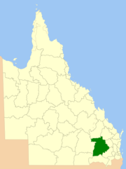
Location within QueenslandPopulation: 32,071(2010)[1] Established: 2008 LGAs around Western Downs Region: Central Highlands Banana South and North Burnett Maranoa Western Downs Region Toowoomba Balonne Goondiwindi Toowoomba The Western Downs Region is a Local Government Area in Queensland, Australia. The Local Government Area was created in March 2008 as a result of the report of the Local Government Reform Commission released in July 2007. The new Council, located in the Darling Downs region contains the entire area of five previous Local Government Areas;
as well as Division 2 of Shire of Taroom.
The report recommends that the new local government area should not be divided into wards and elect ten councillors and a mayor. The Council will cover an area 38,039 square kilometres (14,687 sq mi), contain an estimated resident population in 2006 of 30,018 and have an estimated operating budget of A$74 million.
Originally called Dalby Regional Council, a name change to Western Downs was approved in August 2009.[2]
The Regional Council covers the towns of Bell, Brigalow, Chinchilla, Condamine, Dalby, Drillham, Dulacca, Jandowae, Jimbour, Kaimkillenbun, Kogan, Miles, Moonie, Tara, The Gums, Wandoan and Warra.
References
- ^ Australian Bureau of Statistics (31 March 2011). "Regional Population Growth, Australia, 2009–10". http://www.abs.gov.au/ausstats/abs@.nsf/Products/3218.0~2009-10~Main+Features~Queensland?OpenDocument. Retrieved 11 June 2011.
- ^ "Council set to launch new identity". Western Downs Regional Council. 5 August 2009. http://www.dalbyrc.qld.gov.au/news/2009/news_mr_council_new_identity_set_for_launch.shtml. Retrieved 2009-08-25.[dead link]
External links
Towns in the Western Downs Region | Darling Downs | Queensland Darling Downs, Queensland Cities: Townships: Acland · Allora · Amiens · Applethorpe · Ballandean · Bell · Brigalow · Bungunya · Cambooya · Cecil Plains · Chinchilla · Clifton · Condamine · Cooyar · Crows Nest · Dalby · Dalveen · Daymar · Drillham · Dulacca · Goombungee · Goondiwindi · Gowrie Junction · Greenmount · Haden · Hampton · Highfields · Inglewood · Jandowae · Jimbour · Karara · Kaimkillenbun · Killarney · Kingsthorpe · Kogan · Kulpi · Leyburn · Macalister · Maclagan · Maryvale · Meandarra · Meringandan · Messines · Miles · Millmerran · Moonie · Nobby · Oakey · Passchendaele · Peranga · Pittsworth · Pozieres · Quinalow · Stanthorpe · Southbrook · Talwood · Texas · Tara · The Gums · Thulimbah · Toobeah · Wallangarra · Wandoan · Warra · Weengallon · Wyberba · Wyreema · Yangan · Yarraman · YelarbonLocal Government Areas: Goondiwindi Region · Southern Downs Region · Toowoomba Region · Western Downs RegionNational Parks: Bunya Mountains · Girraween · Main Range · Mount Binga · Southwood · Sundown · The Palms · Wondul RangeLocal Government Areas of Queensland South East Brisbane · Gold Coast · Ipswich · Lockyer Valley · Logan · Moreton Bay · Redland · Scenic Rim · Somerset · Sunshine CoastWide Bay-Burnett Darling Downs Goondiwindi · Southern Downs · Toowoomba · Western DownsCentral Central Highlands · Gladstone · Isaac · Mackay · Rockhampton · WoorabindaNorth Far North Aurukun · Cairns · Cassowary Coast · Cook · Hopevale · Kowanyama · Lockhart River · Mapoon · Napranum · Northern Peninsula Area · Pormpuraaw · Tablelands · Torres · Torres Strait Islands · Weipa · Wujal Wujal · YarrabahNorth West Central West South West Coordinates: 26°44′32″S 150°35′35″E / 26.74222°S 150.59306°E
Categories:- Populated places established in 2008
- 2008 establishments in Australia
- Local Government Areas of Queensland
- Darling Downs
- Queensland geography stubs
Wikimedia Foundation. 2010.

