- City of Mount Isa
-
City of Mount Isa
Queensland
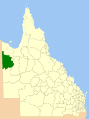
Location within QueenslandPopulation: 21,994(2010)[1] Established: 1914 Area: 43348.6 km² (16,737.0 sq mi) Mayor: John Molony Council Seat: Mount Isa State District: Mount Isa Federal Division: Kennedy LGAs around City of Mount Isa: Roper Gulf (NT) Burke Burke Barkly (NT) City of Mount Isa Cloncurry Barkly (NT) Boulia Cloncurry The City of Mount Isa is a Local Government Area located in north west Queensland. The City covers the urban locality of Mount Isa, the administrative centre, and surrounding area, sharing a boundary with the Northern Territory to the west.
Industry in the City is based around the Mount Isa Mines, a source of lead, copper, silver and zinc. Cattle grazing and tourism are other industries of note.
Contents
History
On 10 February 1914, the Shire of Barkly Tableland, based in Camooweal, was incorporated on an area previously managed by the shires of Burke and Cloncurry. It was spelt "Barclay" until 14 August 1919. As a consequence of the growth of Mount Isa as a mining and population centre within the shire, an Order in Council dated 15 December 1962 renamed the shire to Shire of Mount Isa, effective 1 July 1963, and its administration centre relocated to Mount Isa. At the same time it gained part of Cloncurry. On 30 May 1968, the shire was proclaimed as a City due to the area reaching a population of 18,000.
Towns and localities
-
- Breakaway
- Fisher
- Happy Valley
- Healy
- Kalkadoon
- Lanskey
- Menzies
- Mica Creek
- Miles End
- Mornington
-
- Mount Isa City
- Mount Isa East
- Parkside
- Pioneer
- Ryan
- Soldiers Hill
- Spreadborough
- Sunset
- The Gap
- Townview
- Winston
- Barkly
- Camooweal
- Gunpowder
- Lawn Hill
Sister cities
Sister cities of Mount Isa include:
 Bankstown, Sydney, New South Wales
Population
Year Population 1954 7,884 1961 13,967 1966 17,485 1971 26,502 1976 26,536 1981 24,390 1986 23,927 1991 24,735 1996 22,866 2001 21,636 2006 21,201 References
- ^ Australian Bureau of Statistics (31 March 2011). "Regional Population Growth, Australia, 2009–10". http://www.abs.gov.au/ausstats/abs@.nsf/Products/3218.0~2009-10~Main+Features~Queensland?OpenDocument. Retrieved 11 June 2011.
Local Government Areas of Queensland South East Brisbane · Gold Coast · Ipswich · Lockyer Valley · Logan · Moreton Bay · Redland · Scenic Rim · Somerset · Sunshine CoastWide Bay-Burnett Darling Downs Central Central Highlands · Gladstone · Isaac · Mackay · Rockhampton · WoorabindaNorth Far North Aurukun · Cairns · Cassowary Coast · Cook · Hopevale · Kowanyama · Lockhart River · Mapoon · Napranum · Northern Peninsula Area · Pormpuraaw · Tablelands · Torres · Torres Strait Islands · Weipa · Wujal Wujal · YarrabahNorth West Burke · Carpentaria · Cloncurry · Croydon · Doomadgee · Etheridge · Flinders · McKinlay · Mornington · Mount Isa · RichmondCentral West South West Coordinates: 20°43′29″S 139°29′36.55″E / 20.72472°S 139.4934861°E
Categories:- Populated places established in 1914
- 1914 establishments in Australia
- Local Government Areas of Queensland
- North West Queensland
-
Wikimedia Foundation. 2010.
