- North Burnett Region
-
North Burnett Region
Queensland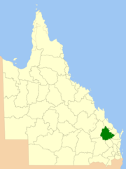
Location in QueenslandPopulation: 10,805(2010)[1] Established: 2008 Area: 19708 km² (7,609.3 sq mi) Mayor: Joy Jensen Council Seat: Gayndah Region: Wide Bay-Burnett State District: Callide Federal Division: Flynn, Hinkler 
LGAs around North Burnett Region: Banana Gladstone Gladstone Banana North Burnett Region Bundaberg Western Downs South Burnett Gympie, Fraser Coast The North Burnett Region is a Local Government in Queensland, Australia located in the northern catchment of the Burnett River. Established in 2008, it was preceded by several previous local government areas with histories extending back to the early 1900s.
It has an estimated operating budget of A$32m.
Contents
History
Prior to the North Burnett Region's creation in 2008, its area was previously divided into six separate local government areas:
- Shire of Biggenden;
- Shire of Eidsvold;
- Shire of Gayndah;
- Shire of Monto;
- Shire of Mundubbera; and
- Shire of Perry.
The first local government in the North Burnett area was the Gayndah Municipality, which was created on 28 November 1866 under the Municipal Corporations Act 1864. On 11 November 1879, the Rawbelle and Perry Divisions were created to serve regional areas under the Divisional Boards Act 1879. A third division, Eidsvold, was proclaimed on 25 January 1890.
On 31 March 1903, following the enactment of the Local Authorities Act 1902, Gayndah became a Town while the three divisions became Shires. On 3 June 1905, the Shire of Degilbo, centred on Biggenden, was established from part of the Shire of Burrum. On 19 May 1915, the Shire of Auburn (later renamed Mundubbera) was separately incorporated. On 17 March 1923, the Shire of Rawbelle was renamed Gayndah and on 24 May 1924, it absorbed the Town. On 3 March 1932, the Shire of Monto came into being and Eidsvold was reincorporated. Finally, on 12 July 1941, Degilbo was renamed Biggenden.
In July 2007, the Local Government Reform Commission released its report and recommended that the six areas amalgamate, asserting that there were "inefficiencies with having six local governments to manage the economic and community interests of a relatively small geographic region which has a static population of just over 10,000". It believed amalgamation would offer potential for both strategic planning and improving the quality of governance and decision-making, as well as allowing one of the towns to emerge as a regional centre for the area. Queensland Treasury had rated all of the councils for financial sustainability, with all except Perry and Biggenden attracting a weak rating. Each of the councils apart from Gayndah opposed the Commission's model, with several suggesting either amalgamation with one or two other shires, or with local governments outside the region (in particular the Shire of Kolan and Gladstone/Calliope). In the end, its proposal was unchanged.[2] On 15 March 2008, the Shires formally ceased to exist, and elections were held on the same day to elect councillors and a mayor to the Regional Council.
Wards and councillors
The council has been divided into 6 divisions, each electing one councillor, with a mayor elected by the entire Region. Joy Jensen, the mayor for the Shire of Perry, was elected at the March 2008 local government elections, as were the following councillors:[3]
- Division 1: Paul Lobegeier
- Division 2: Paul Francis
- Division 3: Faye Whelan
- Division 4: Peter Huth
- Division 5: Peter Baker
- Division 6: Kevin (Lofty) Wendt
Towns and localities
- Abercorn
- Ban Ban Springs
- Biggenden
- Binjour
- Boynewood
- Byrnestown
- Ceratodus
- Coalstoun Lakes
- Dallarnil
- Degilbo
- Didcot
- Eidsvold
- Gayndah
- Gooroolba
- Ideraway
- Kalpowar
- Monogorilby
- Monto
- Moonford
- Mount Perry
- Mulgildie
- Mundowran
- Mundubbera
- Mungungo
- Philpott
- Wetheron
- Wuruma Dam
Population
Year Total Region Biggenden Eidsvold Gayndah Monto Mundubbera Perry 1933 14,322 2,476 1,475 3,760 3,514 2,302 795 1947 13,861 2,179 1,313 3,407 4,270 2,064 628 1954 13,917 1,974 1,311 3,352 4,458 2,326 496 1961 13,993 1,882 1,242 3,400 4,397 2,617 455 1966 13,715 1,722 1,702 3,182 4,155 2,580 374 1971 12,230 1,639 1,222 3,107 3,495 2,391 376 1976 11,504 1,532 1,231 2,814 3,228 2,395 304 1981 11,565 1,411 1,256 2,859 3,249 2,481 309 1986 11,583 1,553 1,212 2,887 3,266 2,355 310 1991 11,230 1,574 1,028 2,856 3,058 2,340 374 1996 11,243 1,570 970 2,916 2,922 2,514 351 2001 10,782 1,486 933 2,894 2,592 2,451 426 2006 10,551 1,506 876 2,911 2,577 2,236 445 External links
- Report of the Local Government Reform Commission (Queensland Department of Local Government, Sport, and Recreation Download Page) Retrieved 17 April 2008
- Interactive Map of North Burnett Region (from Electoral Commisiion Queensland website) Retrieved 17 April 2008
References
- ^ Australian Bureau of Statistics (31 March 2011). "Regional Population Growth, Australia, 2009–10". http://www.abs.gov.au/ausstats/abs@.nsf/Products/3218.0~2009-10~Main+Features~Queensland?OpenDocument. Retrieved 11 June 2011.
- ^ Queensland Local Government Reform Commission (July 2007). Report of the Local Government Reform Commission. 2. pp. 228–233. ISBN 1921057114. http://www.dlgp.qld.gov.au/resources/map/reform/north-burnett-rationale.pdf. Retrieved 17 September 2009.
- ^ North Burnett Region Councillor Election results Retrieved 17 April 2008
Towns and communities in the North Burnett Region | Wide Bay-Burnett | Queensland Abercorn · Ban Ban Springs · Biggenden · Binjour · Byrnestown · Ceratodus · Coulston Lakes · Dallarnil · Degilbo · Didcot · Eidsvold · Gayndah · Gooroolba · Humphery · Ideraway · Kalpowar · Moonford · Monto · Mount Perry · Mulgildie · Mundubbera · Mungungo
Local Government Areas of Queensland South East Brisbane · Gold Coast · Ipswich · Lockyer Valley · Logan · Moreton Bay · Redland · Scenic Rim · Somerset · Sunshine CoastWide Bay-Burnett Darling Downs Central Central Highlands · Gladstone · Isaac · Mackay · Rockhampton · WoorabindaNorth Far North Aurukun · Cairns · Cassowary Coast · Cook · Hopevale · Kowanyama · Lockhart River · Mapoon · Napranum · Northern Peninsula Area · Pormpuraaw · Tablelands · Torres · Torres Strait Islands · Weipa · Wujal Wujal · YarrabahNorth West Central West South West Coordinates: 25°37′30″S 151°36′20″E / 25.625°S 151.60556°E
Categories:- Populated places established in 2008
- 2008 establishments in Australia
- Local Government Areas of Queensland

Wikimedia Foundation. 2010.