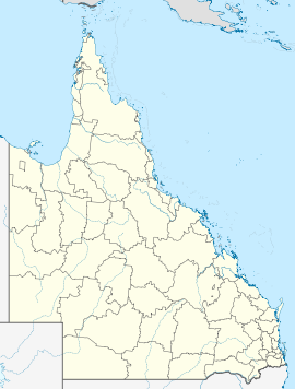
- Mount Perry, Queensland
-
Mount Perry
QueenslandPopulation: 431[1] Postcode: 4671 Coordinates: 25°12′S 151°39′E / 25.2°S 151.65°ECoordinates: 25°12′S 151°39′E / 25.2°S 151.65°E Location: LGA: North Burnett Region State District: Callide Federal Division: Flynn Mount Perry is a small town in the North Burnett Region in southeastern Queensland, Australia. Mount Perry is about 365 kilometres (227 mi) northwest of Brisbane, the capital of Queensland, and about 100 kilometres (62 mi) west of Bundaberg. At the 2006 census, Mount Perry and the surrounding area had a population of 431.[1]
It is a historically significant town nestled in a valley near Mount Perry, the area's highest mountain. Befitting its village-like status, there is just one general store, one petrol station, one post office (with bank agency), one primary school, two motels and one golf course.
Mount Perry was connected by a railway line to Bundaberg from 1884 until 1960.[2]
Gold mining continues to be an important industry in the area, while the popular Mount Perry Races remains a fixture on the calendars of many people in the area, especially Solomon Gold, a company that operate in the town.
See also
- Boolboonda Tunnel
References
- ^ a b Australian Bureau of Statistics (25 October 2007). "Mount Perry (Perry Shire) (State Suburb)". 2006 Census QuickStats. http://www.censusdata.abs.gov.au/ABSNavigation/prenav/LocationSearch?collection=Census&period=2006&areacode=SSC36897&producttype=QuickStats&breadcrumb=PL&action=401. Retrieved 2008-07-05.
- ^ Rails to Mount Perry Milne, Rod Australian Railway Historical Society Bulletin, August, 1998 pp294-301
External links
Towns and communities in the North Burnett Region | Wide Bay-Burnett | Queensland Abercorn · Ban Ban Springs · Biggenden · Binjour · Byrnestown · Ceratodus · Coulston Lakes · Dallarnil · Degilbo · Didcot · Eidsvold · Gayndah · Gooroolba · Humphery · Ideraway · Kalpowar · Moonford · Monto · Mount Perry · Mulgildie · Mundubbera · Mungungo
Categories:- Towns in Queensland
Wikimedia Foundation. 2010.

