- Shire of Mount Morgan
-
Shire of Mount Morgan
Queensland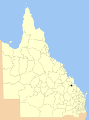
Location within QueenslandPopulation: 2,925(2006 census)[1] Established: 1890 Area: 492.0 km² (190.0 sq mi) Council Seat: Mount Morgan Region: Capricornia 
LGAs around Shire of Mount Morgan: Fitzroy Fitzroy Fitzroy Banana Shire of Mount Morgan Fitzroy Banana Banana Banana The Shire of Mount Morgan was a Local Government Area located in the Capricornia region of Central Queensland, Queensland, Australia, about 20 kilometres (12 mi) south of the regional city of Rockhampton. The shire, which was based around the former gold mining town of Mount Morgan, covered an area of 492.0 square kilometres (190.0 sq mi), and existed as a local government entity from 1890 until 2008, when it amalgamated with several other councils to become the Rockhampton Region.
Contents
History
Mount Morgan came into being with the discovery of gold in the area in 1882. It was established as a Municipality on 22 May 1890, becoming a town on 31 March 1903 with the enactment of the Local Authorities Act 1902. On 17 March 1909, the surrounding area, previously part of the Shire of Banana, was incorporated as the Shire of Calliungal.[2] On 5 November 1931, the two merged to form the Shire of Mount Morgan.
On 15 March 2008, under the Local Government (Reform Implementation) Act 2007 passed by the Parliament of Queensland on 10 August 2007, the Shire of Mount Morgan merged with the City of Rockhampton and the Shires of Livingstone and Fitzroy to form the Rockhampton Region.
Towns and localities
- Mount Morgan
- Baree
- Hamilton Creek
- Horse Creek
- Moongan
- The Mine
- Walterhall
Population
Year Population 1933 4,404 1947 4,954 1954 5,060 1961 4,871 1966 4,421 1971 3,967 1976 3,467 1981 3,136 1986 3,108 1991 3,093 1996 2,858 2001 2,776 2006 2,925 References
- ^ Australian Bureau of Statistics (25 October 2007). "Mount Morgan (S) (Local Government Area)". 2006 Census QuickStats. http://www.censusdata.abs.gov.au/ABSNavigation/prenav/LocationSearch?collection=Census&period=2006&areacode=LGA35350&producttype=QuickStats&breadcrumb=PL&action=401. Retrieved 2008-03-18.
- ^ "Order in Council". Queensland Government Gazette: p. 92:735. 17 March 1909.
Coordinates: 23°38′40.21″S 150°23′14.39″E / 23.6445028°S 150.3873306°E
Categories:- Populated places established in 1890
- 1890 establishments in Australia
- Former Local Government Areas of Queensland

Wikimedia Foundation. 2010.