- Shire of Perry
Infobox Australian Place | type = lga
name = Shire of Perry
state = qld
imagesize= 135
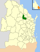
caption = Location withinQueensland
pop = 445
pop_footnotes = (2006 census) [Census 2006 AUS | id = LGA35900 | name = Perry (S) (Local Government Area) | accessdate=2008-03-18|quick = on]
area = 2357.7
est = 1880
seat = Mount Perry
region =Wide Bay-Burnett
logosize = 100
url = http://www.perry.qld.gov.au/
near-nw = Monto
near-n = Monto
near-ne = Kolan
near-w = Eidsvold
near-e = Kolan
near-sw = Gayndah
near-s = Gayndah
near-se = BiggendenThe Shire of Perry was a Local Government Area located in the northern catchment of the
Burnett River ,Queensland ,Australia . The shire covered an area of convert|2357.7|km2|sqmi|1, and existed as a local government entity from 1880 until 2008, when it amalgamated with several other councils in the region to become theNorth Burnett Regional Council .It is centred on the town of Mount Perry, the shire's only town.
History
The Perry Divisional Board was created under the "Divisional Boards Act 1879" and had its first meeting on 6 March 1880.
On 15 March 2008, under the "Local Government (Reform Implementation) Act 2007" passed by the
Parliament of Queensland on 10 August 2007, the Shire of Biggenden merged with the Shires of Biggenden, Eidsvold, Gayndah, Monto and Mundubbera to form theNorth Burnett Regional Council .Population
Mayors
Joy Jensen was the last mayor of the Perry Shire Council. Despite leading the smallest of the six North Burnett councils, she won the mayoralty of the new
North Burnett Regional Council at the elections on 15 March 2008.References
Wikimedia Foundation. 2010.