- Shire of Monto
-
Shire of Monto
Queensland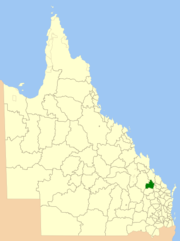
Location within QueenslandPopulation: 2,577(2006 census)[1] Established: 1932 Area: 4320.8 km² (1,668.3 sq mi) Council Seat: Monto Region: Wide Bay-Burnett 
LGAs around Shire of Monto: Banana Banana Calliope Banana Shire of Monto Perry Banana Eidsvold Perry The Shire of Monto was a Local Government Area located in the northern catchment of the Burnett River, Queensland, Australia. The shire covered an area of 4,320.8 square kilometres (1,668.3 sq mi), and existed as a local government area from 1932 until 2008, when it amalgamated with several other shires to form the North Burnett Region.
Contents
History
The Monto district came into being as part of a Land Development Scheme for returning soldiers. The first town buildings were erected in 1926, followed by the Butter Factory in 1927. In July 1931 the railway was officially opened and on 3 March 1932, the Shire of Monto was proclaimed on land previously administered by the Shires of Eidsvold and Mundubbera. The town of Monto also briefly served as the administrative centre of Eidsvold.
On 15 March 2008, under the Local Government (Reform Implementation) Act 2007 passed by the Parliament of Queensland on 10 August 2007, the Shire of Monto merged with the Shires of Biggenden, Eidsvold, Gayndah, Mundubbera and Perry to form the North Burnett Region.
Localities
Localities within the Monto Shire were: Bancroft, Bukali, Cania, Cannindah, Coominglah, Coominglah Forest, Glenleigh, Harrami, Kalpowar, Kapaldo, Langley, Monal, Monto, Moonford, Mulgildie, Mungungo, Rawbelle, Selene, Splinter Creek, Three Moon, Tellebang and Ventnor.
Population
Year Population 1933 3,514 1947 4,270 1954 4,458 1961 4,397 1966 4,155 1971 3,495 1976 3,228 1981 3,249 1986 3,266 1991 3,058 1996 2,922 2001 2,592 2006 2,577 References
- ^ Australian Bureau of Statistics (25 October 2007). "Monto (S) (Local Government Area)". 2006 Census QuickStats. http://www.censusdata.abs.gov.au/ABSNavigation/prenav/LocationSearch?collection=Census&period=2006&areacode=LGA35150&producttype=QuickStats&breadcrumb=PL&action=401. Retrieved 2008-03-18.
Categories:- Populated places established in 1932
- 1932 establishments in Australia
- Former Local Government Areas of Queensland
- Queensland geography stubs

Wikimedia Foundation. 2010.