- Shire of Burnett
Infobox Australian Place | type = lga
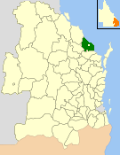
name = Shire of Burnett
state = qld
imagesize= 135
caption = Location withinQueensland
pop = 27,232
pop_footnotes = (2006 census) [Census 2006 AUS | id = LGA31980 | name = Burnett (S) (Local Government Area) | accessdate=2008-03-18|quick = on]
area = 2000.8
est = 1994
seat = Bargara (160 Hughes Rd)
region =Wide Bay-Burnett

logosize = 120
url = http://www.burnett.qld.gov.au/
near-nw = Kolan
near-n = Miriam Vale
near-ne = "Coral Sea "
near-e = "Coral Sea "
near-w = Kolan
near-sw = Isis
near-s = Isis
near-se = Hervey BayThe Shire of Burnett was a Local Government Area located in the
Wide Bay-Burnett region ofQueensland ,Australia , and completely surrounded, but did not include, the regional city of Bundaberg. The shire covered an area of convert|2000.8|km2|sqmi|1, and existed as a local government entity from its creation through the amalgamation of Gooburrum and Woongarra shires until 2008, when it amalgamated with theCity of Bundaberg and other councils in the region to form theBundaberg Regional Council .History
On 21 November 1991, the
Electoral and Administrative Review Commission , created two years earlier, produced its second report, and recommended that local government boundaries in the Bundaberg area be rationalised. The "Local Government (Bundaberg and Burnett) Regulation 1993" was gazetted on 17 December 1993, in effect amalgamating the Shires of Gooburrum and Woongarra, and transferring a newer urban area to theCity of Bundaberg . On 30 March 1994, the Shire of Burnett came into being.On 15 March 2008, under the "Local Government (Reform Implementation) Act 2007" passed by the
Parliament of Queensland on 10 August 2007, the Shire of Burnett merged with theCity of Bundaberg and the Shires of Isis and Kolan to form theBundaberg Regional Council .Population
* Excluding the area transferred to City of Bundaberg in 1994, the population of Burnett was 15,417 in 1991.
Towns and localities
External links
* [http://www.burnett.qld.gov.au Burnett Council]
References
Wikimedia Foundation. 2010.