- Shire of Cook
-
Shire of Cook
Queensland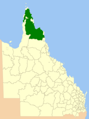
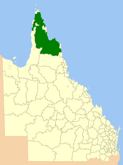
Location within QueenslandPopulation: 3,976(2010)[1] Established: 1919 Area: 106188.4 km² (40,999.6 sq mi) Council Seat: Cooktown Region: Far North Queensland State District: Cook Federal Division: Leichhardt LGAs around Shire of Cook: Gulf of Carpentaria Torres Coral Sea Gulf of Carpentaria, Aurukun Shire of Cook Coral Sea Carpentaria Tablelands Cairns The Shire of Cook is a Local Government Area located in Far North Queensland, Australia. The shire covers most of the eastern and central parts of Cape York Peninsula, the most northerly section of the Australian mainland.
It covers an area of 106,188.4 square kilometres (40,999.6 sq mi), and has existed as a local government entity since 1919.
Contents
History
The Daintree and Hann Divisional Boards were created on 11 November 1879 as two of 74 divisions around Queensland under the Divisional Boards Act 1879, With the passage of the Local Authorities Act 1902, they became shires on 31 March 1903. On 16 January 1919, they merged to form the Shire of Cook.
The separate Cooktown Municipality was proclaimed on 3 April 1976 under the Municipal Institutions Act 1864, and merged with Cook Shire on 24 August 1932.[2]
Prior to 2005, a number of Aboriginal communities administered under Deed of Grant in Trust by community councils were part of the Shire's area, but they were formally excised and given a new status as Aboriginal Shires. This formed part of the Meeting Challenges, Making Choices strategy developed in response to the Cape York Justice Study undertaken by Justice Fitzgerald QC in November 2001.[3]
The Local Government Reform process in July 2007 concluded that amalgamation of the Shire would not result in any benefits to service delivery and management for the area, noting that it was (and is) the largest local government by area and had no community of interest with any neighbouring areas. The council was, however, reduced from seven to six councillors with an additional elected mayor.[4]
Towns and localities
- Cooktown (pop 1,336)
- Laura (pop 570)
- Coen (pop 253)
- Archer River
- Ayton
- Helenvale
- Lakeland
- Lizard Island
- Marton
- Merapah
- Portland Roads
- Rossville
- Shelburne
- Starcke
Population
The population of the Shire of Cook, along with Torres, Aurukun and Mornington, have been singled out by the Australian Bureau of Statistics (ABS), who conduct the quinquennial census, as particularly difficult to measure accurately. Reasons for this include cultural and language barriers, transport and geographical spread of the population, who are mostly located in isolated communities. As such, all figures are likely to be lower than the actual population on the census date. Additionally, prior to 1971, Aboriginal people who form a majority of the population were not counted in census statistics.
Until 1 July 2002, the Australian Bureau of Statistics included the Island and DOGIT councils within the Shire of Cook statistical local area. Information for the reduced Shire back to 1996 has been provided on the ABS website through the Time Series Profile.
Year Population 1933 2,068 1947 1,139 1954 1,545 1961 1,869 1966 2,463 1971 5,538 1976 6,128 1981 4,456 1986 4,776 1991 8,785 1996 5,232 2001 4,776 2006 4,653 References
- ^ Australian Bureau of Statistics (31 March 2011). "Regional Population Growth, Australia, 2009–10". http://www.abs.gov.au/ausstats/abs@.nsf/Products/3218.0~2009-10~Main+Features~Queensland?OpenDocument. Retrieved 11 June 2011.
- ^ "Order in Council". Queensland Government Gazette: p. 138:400. 6 August 1932.
- ^ McDougall, Scott (January 2006) (PDF). Palm Island: Future Directions - Resource Officer Report. Brisbane, Queensland: Queensland Department of Aboriginal and Torres Strait Islander Policy. pp. page 27. http://www.datsip.qld.gov.au/resources/publications/documents/future-directions-palm-island-resource-officer-report.pdf.
- ^ Queensland Local Government Reform Commission (July 2007). Report of the Local Government Reform Commission. 2. pp. 93–96. ISBN 1921057114. http://www.localgovernment.qld.gov.au/docs/local_govt/stronger-councils/maps/Cook_rationale.pdf. Retrieved 17 September 2009.
External links
Local Government Areas of Queensland South East Brisbane · Gold Coast · Ipswich · Lockyer Valley · Logan · Moreton Bay · Redland · Scenic Rim · Somerset · Sunshine CoastWide Bay-Burnett Darling Downs Central Central Highlands · Gladstone · Isaac · Mackay · Rockhampton · WoorabindaNorth Far North Aurukun · Cairns · Cassowary Coast · Cook · Hopevale · Kowanyama · Lockhart River · Mapoon · Napranum · Northern Peninsula Area · Pormpuraaw · Tablelands · Torres · Torres Strait Islands · Weipa · Wujal Wujal · YarrabahNorth West Central West South West Coordinates: 15°28′05.4″S 145°15′02″E / 15.468167°S 145.25056°E
Categories:- Populated places established in 1919
- 1919 establishments in Australia
- Local Government Areas of Queensland
Wikimedia Foundation. 2010.