- Shire of Douglas
-
Shire of Douglas
Queensland
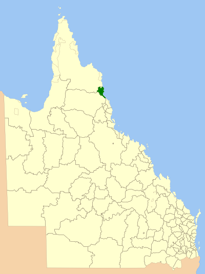
Location within QueenslandPopulation: 14,024(2006 census)[1] Established: 1880 Area: 2436.7 km² (940.8 sq mi) Council Seat: Mossman Region: Far North Queensland 
LGAs around Shire of Douglas: Cook Cook Coral Sea Mareeba Shire of Douglas Coral Sea Mareeba Cairns Cairns The Shire of Douglas was a Local Government Area in Far North Queensland. It was located on the coast north of the city of Cairns. The shire, administered from the town of Mossman, covered an area of 2,436.7 square kilometres (940.8 sq mi), and existed as a local government entity from 1880 until 2008, when it amalgamated with the City of Cairns to become the Cairns Region.
The major industries are tourism and sugar production. Minor industries include tropical fruit, cocoa, and beef.
Contents
History
Douglas Divisional Board was created on 3 June 1880 under the Divisional Boards Act 1879. With the passage of the Local Authorities Act 1902, Douglas became a shire council on 31 March 1903.
On 15 March 2008, under the Local Government (Reform Implementation) Act 2007 passed by the Parliament of Queensland on 10 August 2007, the Shire of Douglas merged with the City of Cairns to form the Cairns Region.
Towns and localities
- Bamboo
- Bloomfield
- Cape Kimberley
- Cape Tribulation
- Cassowary
- Cooya Beach
- Cow Bay
- Craiglie
- Daintree
- Dayman Point
- Diwan
- Ellis Beach (until 1995)
- Finlay Vale
- Four Mile Beach
- Killaloe
- Low Isles
- Miallo
- Mossman Gorge
- Mowbray
- Newell
- Oak Beach
- Shannonvale
- Stewart Creek Valley
- Thornton Beach
- Wangetti
- Whyanbeel
- Wonga
Population
Year Population 1933 2,901 1947 2,493 1954 3,100 1961 3,354 1966 3,919 1971 4,072 1976 4,746 1981 5,957 1986 7,750 1991 12,440 1996 12,980 2001 13,966 2006 14,024 Mayors
The following were mayors of the Shire of Douglas:[2]
- Andrew Jack — 1900
- James Reynolds — 1901–1903
- R. A. Donnelly — 1904–1905
- W. Mackay — 1906
- D. J. Kirwan — 1907
- R. D. Low — 1908
- R. Walsh — 1909
- R. P. Tunnie — 1910
- Fred Thompson — 1911–1912
- J. P. Reynolds — 1913
- R. P. Tunnie — 1914
- J. P. Reynolds — 1915–1921
- John Quill — 1921–1927
- Barney Andreassen — 1927–1933
- Raymond Rex — 1933–1955
- E. D. Berzinski — 1955–1964
- George Quaid Jr. — 1964–1967
- J. S. Allen — 1967–1970
- O. R. Andrews — 1970–1981
- Anthony Mijo — 1982–1991
- Mike Berwick — 1991–2008
References
- ^ Australian Bureau of Statistics (25 October 2007). "Douglas (S) (Local Government Area)". 2006 Census QuickStats. http://www.censusdata.abs.gov.au/ABSNavigation/prenav/LocationSearch?collection=Census&period=2006&areacode=LGA32800&producttype=QuickStats&breadcrumb=PL&action=401. Retrieved 2009-04-16.
- ^ Douglas Shire Mayors, Cairns Regional Council, accessed 16 April 2009
External links
Categories:- Populated places established in 1880
- 1880 establishments in Australia
- Former Local Government Areas of Queensland
- Far North Queensland
Wikimedia Foundation. 2010.