- Shire of Kilkivan
Infobox Australian Place | type = lga
name = Shire of Kilkivan
state = qld
imagesize= 135
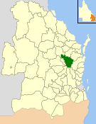
caption = Location withinQueensland
area = 3263.4
est = 1886
seat = Kilkivan
pop = 3,431
pop_footnotes = (2006 census) [Census 2006 AUS | id = LGA34300 | name = Kilkivan (S) (Local Government Area) | accessdate=2008-03-18|quick = on]
region =
logosize = 125
url = http://www.kilkivanshire.qld.gov.au/
near-nw = Gayndah
near-n = Woocoo
near-ne = Tiaro
near-e = Cooloola
near-w = Murgon
near-sw = Nanango
near-s = Esk
near-se = KilcoyThe Shire of Kilkivan was a Local Government Area located about convert|180|km|mi|0 north-northwest of
Brisbane , the state capital ofQueensland ,Australia . The shire covered an area of convert|3263.4|km2|sqmi|1, and existed from 1886 until its merger with several other councils to form theGympie Regional Council on 15 March 2008.History
The Kilkivan area was the centre of a
gold rush in the late 1860s. As the gold was mined out, agriculture became established in the region.Kilkivan Divisional Board was created on 3 July 1886 out of parts of the Widgee and Barambah Divisions under the "Divisional Boards Act 1879". It was abolished four weeks later, but reconstituted on 19 November 1887 with a slightly larger area. ["Queensland Government Gazette", 3 July 1886 (1886:4); 31 July 1886 (1886:324); 19 November 1887 (1886:979).] With the passage of the "Local Authorities Act 1902", Kilkivan became a shire council on 31 March 1903. The Shire was not subdivided into wards or divisions, and the council consisted of an elected mayor and six councillors.
The Kilkivan and District Historical Society was founded in 1979 and established a Shire Museum in Bligh Street, Kilkivan, near the site of a former goldfield. The shire came to host two major annual festivals—the Kilkivan Great Horse Ride in April, and the Goomeri Pumpkin Festival on the last Sunday in May.
On 15 March 2008, under the "Local Government (Reform Implementation) Act 2007" passed by the
Parliament of Queensland on 10 August 2007, Kilkivan merged with theShire of Cooloola and part of Tiaro to form theGympie Regional Council . [cite news|url=http://www.gympietimes.com.au/storydisplay.cfm?storyid=3766352|title=Sad end to Kilkivan Shire|date=12 March 2008|work=Gympie Times|accessdate=2008-03-19] At the elections on that day, Kilkivan's mayor, Ron Dyne, became the first mayor of the new council. [cite news|url=http://abc.com.au/news/stories/2008/03/19/2194266.htm|title=Dyne scores Gympie Regional Council's top job|date=19 March 2008|work=ABC Online|accessdate=2008-03-19]Towns and Localities
* Kilkivan
* Goomeri
* Johnstown
* Kinbombi
* Manumbar
* Tansey
* Widgee
* WooloogaPopulation
Mayors
* Ron Dyne (2004–2008)
* David Lahiff (2000–2004)References
Further reading
* (492 pages)
Wikimedia Foundation. 2010.