- Shire of Kilcoy
Infobox Australian Place | type = lga
name = Shire of Kilcoy
state = qld
imagesize= 135
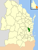
caption = Location withinQueensland
area = 1445.2
est = 1912
seat = Kilcoy
pop = 3,424
pop_footnotes = (2006 census) [Census 2006 AUS | id = LGA34250 | name = Kilcoy (S) (Local Government Area) | accessdate=2008-03-18|quick = on]
region =South East Queensland
logosize = 133
url = http://www.kilcoy.qld.gov.au/
near-nw = Kilkivan
near-n = Cooloola
near-ne = Cooloola
near-w = Esk
near-e = Maroochy, Caloundra
near-sw = Esk
near-s = Esk
near-se = CabooltureThe Shire of Kilcoy was a Local Government Area in South East
Queensland ,Australia , located about convert|95|km|mi|0 northwest ofBrisbane along theD'Aguilar Highway , not far from the Sunshine Coast. The shire covered an area of convert|1445.2|km2|sqmi|1, and existed from 1912 until its merger with theShire of Esk to form theSomerset Regional Council on 15 March 2008.Beef cattle is the predominant industry in the area, with other activities including dairying, small crops and aquaculture.
History
The area was originally incorporated as part of the Caboolture Divisional Board on 11 November 1879 under the "Divisional Boards Act 1879". With the passage of the "Local Authorities Act 1902", Caboolture became a shire council on 31 March 1903.
On 22 February 1912, the Shire of Kilcoy split away and was proclaimed in its own right. ["Queensland Government Gazette", 22 February 1912, p.435.] The council consisted of an elected mayor and eight councillors, and was not subdivided.
On 15 March 2008, under the "Local Government (Reform Implementation) Act 2007" passed by the
Parliament of Queensland on 10 August 2007, the Shire of Kilcoy merged with theShire of Esk to form theSomerset Regional Council .Towns
* Kilcoy
* Glenfern
* Hazeldean
* Jimna
* Monsildale
* Villeneuve
* Winya
* Yabba
* YendinaPopulation
Mayors
* Terry Dredge (2000–2008)
* Alex Brown (1985–2000)References
Wikimedia Foundation. 2010.