- Shire of Cambooya
Infobox Australian Place | type = lga
name = Shire of Cambooya
state = qld
imagesize= 135
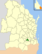
caption = Location withinQueensland
pop = 5,652
pop_footnotes = (2006 census) [Census 2006 AUS | id = LGA32150 | name = Cambooya (S) (Local Government Area) | accessdate=2008-03-18|quick = on]
area = 638.5
est = 1914
seat = Greenmount
region =Darling Downs
logosize = 137
url = http://cambooya.qld.gov.au/
near-nw = Jondaryan
near-n = Toowoomba
near-ne = Gatton
near-w = Pittsworth
near-e = Gatton
near-sw = Clifton
near-s = Clifton
near-se = GattonThe Shire of Cambooya was a Local Government Area located in theDarling Downs region ofQueensland ,Australia , immediately south of the regional city of Toowoomba. The shire, administered from the town of Greenmount, covered an area of convert|638.5|km2|sqmi|1, and existed as a local government entity from 1914 until 2008, when it amalgamated with several other councils in the Toowoomba area to become theToowoomba Regional Council .Its main pursuits included dairying and beef cattle, pig production, horse spelling and breeding, grain growing and vegetable production. The northern section, containing rural-residential suburbs such as Vale View and Hodgson Vale, are commuter districts within convert|12|km|mi|0 of Toowoomba's urban core.
History
The Shire of Cambooya was created by severance from the
Shire of Clifton . It absorbed part of the Tarampa Shire in 1915, and part of Drayton in 1949. [cite web|url=http://www.cambooya.qld.gov.au/mayor.php|title=A Brief History of Cambooya Shire|author=Toowoomba Regional Council|year=2004|accessdate=2008-04-02]Cambooya had four divisions electing two councillors each, with a separately elected mayor.
On 15 March 2008, under the "Local Government (Reform Implementation) Act 2007" passed by the
Parliament of Queensland on 10 August 2007, the Shire of Cambooya merged with theCity of Toowoomba and the Shires of Clifton, Crows Nest, Jondaryan, Millmerran, Pittsworth andShire of Rosalie to form theToowoomba Regional Council .Towns and localities
* Cambooya
* East Greenmount
* Greenmount
* Hodgson Vale
* Nobby (split withShire of Clifton )
* Top Camp
* Vale View
* Westbrook
* Wyreema (split withShire of Jondaryan )Population
# The estimated 1947 population of the post-1949 area was 1,959. ["Queensland Year Book", No.11 (1950), p.47.]
Mayors
* Carol Taylor (2004—2008)
References
Wikimedia Foundation. 2010.