- Shire of Fitzroy
Infobox Australian Place | type = lga
name = Shire of Fitzroy
state = qld
imagesize= 180
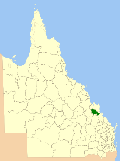
caption = Location withinQueensland
pop = 10,310
pop_footnotes = (2006 census) [Census 2006 AUS | id = LGA33150 | name = Fitzroy (S) (Local Government Area) | accessdate=2008-03-18|quick = on]
area = 5898.7
est = 1899
seat = Gracemere
region = Capricornia

logosize = 80
url = http://www.fitzroyshire.qld.gov.au/
near-nw = Livingstone
near-n = Livingstone
near-ne = Livingstone
near-w = Duaringa
near-e = Rockhampton
near-sw = Banana
near-s = Mount Morgan
near-se = CalliopeThe Shire of Fitzroy was a Local Government Area located in the Capricornia region of
Central Queensland ,Queensland ,Australia , to the immediate west and south of the regional city of Rockhampton. The shire, administered from the town of Gracemere, covered an area of convert|5898.7|km2|sqmi|1, and existed as a local government entity from 1899 until 2008, when it amalgamated with several other councils to become theRockhampton Regional Council . It is named for the Fitzroy River, that passes along the northern boundary of the shire.History
Fitzroy was originally incorporated as part of the Division of Gogango under the "Divisional Boards Act 1879". On 6 April 1899, the section of Gogango south of the Fitzroy River split away to form the Fitzroy Division. With the passage of the "Local Authorities Act 1902", Fitzroy became a shire on 31 March 1903.
On 15 March 2008, under the "Local Government (Reform Implementation) Act 2007" passed by the
Parliament of Queensland on 10 August 2007, the Shire of Fitzroy merged with theCity of Rockhampton and the Shires of Mount Morgan and Livingstone to form theRockhampton Regional Council .Towns and Localities
* Gracemere
* Alton Downs
* Bajool
* Bouldercombe
* Bushley
* Dalma
* Garnant
* Glenroy
* Gogango
* Kabra
* Kalapa
* Marmor
* Midgee
* Morinish
* Morinish South
* Nine Mile
* Pink Lily
* Port Alma
* Ridgelands
* South Yaamba
* Stanwell
* Westwood
* WycarbahPopulation
References
Wikimedia Foundation. 2010.