- Shire of Herberton
"As at 15 March 2008 this former local government area ceased to exist, having been wholly amalgamated into the
Tablelands Regional Council ."Infobox Australian Place | type = lga
name = Shire of Herberton
state = qld
imagesize= 180
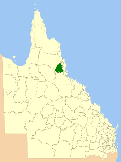
caption = Location withinQueensland
pop = 5,083
area = 9604
est =
seat = Herberton
mayor = Anne Portess
region =Far North Queensland
logosize = 120
url = http://www.herberton.qld.gov.au/
stategov = Tablelands
fedgov = Kennedy
near-nw = Mareeba
near-n = Atherton
near-ne = Eacham
near-w = Mareeba
near-e = Johnstone, Cardwell
near-sw = Etheridge
near-s = Dalrymple
near-se = HinchinbrookShire of Herberton is a Local Government Area in
Far North Queensland ,Australia . The shire includes the towns of Mount Garnet, Ravenshoe and the administrative centre, Herberton.The shire is located in the
Atherton Tableland , a large plateau forming part of theGreat Dividing Range inland from the city of Cairns.External links
* [http://www.lgp.qld.gov.au/applications/lgdirectory/CouncilInfo/Default.aspx?OrgCode=HERB Queensland Department of Local Government & Planning] - Local Government Directory
Wikimedia Foundation. 2010.