- Shire of Diamantina
-
Shire of Diamantina
Queensland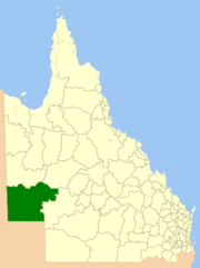
Location within QueenslandPopulation: 322(2010)[1] Established: 1879 Area: 94823.2 km² (36,611.4 sq mi) Mayor: Robbie Dare Council Seat: Bedourie Region: Central West Queensland State District: Mount Isa Federal Division: Maranoa LGAs around Shire of Diamantina: Central Desert (NT) Boulia Winton MacDonnell (NT) Shire of Diamantina Barcoo Outback Areas (SA) Outback Areas (SA) Barcoo The Shire of Diamantina is a Local Government Area located in Central West Queensland, bordering South Australia and the Northern Territory. Like most places in Queensland with the "Diamantina" name, it was named after Lady Diamantina Bowen (née Roma), the wife of the first governor of Queensland, Sir George Bowen.
It covers an area of 94,823.2 square kilometres (36,611.4 sq mi), and has existed as a local government entity since 1879. The town of Birdsville is home to the iconic Birdsville Races, a horse race meeting to raise money for the Royal Flying Doctor Service.
Contents
Towns and localities
- Bedourie
- Betoota
- Birdsville
- Astrebla National Park
- Diamantina National Park
- Simpson Desert National Park
Population
Year Population 1933 214 1947 234 1954 239 1961 327 1966 321 1971 280 1976 255 1981 366 1986 302 1991 332 1996 415 2001 440 2006 401 References
- ^ Australian Bureau of Statistics (31 March 2011). "Regional Population Growth, Australia, 2009–10". http://www.abs.gov.au/ausstats/abs@.nsf/Products/3218.0~2009-10~Main+Features~Queensland?OpenDocument. Retrieved 11 June 2011.
External links
Local Government Areas of Queensland South East Brisbane · Gold Coast · Ipswich · Lockyer Valley · Logan · Moreton Bay · Redland · Scenic Rim · Somerset · Sunshine CoastWide Bay-Burnett Darling Downs Central Central Highlands · Gladstone · Isaac · Mackay · Rockhampton · WoorabindaNorth Far North Aurukun · Cairns · Cassowary Coast · Cook · Hopevale · Kowanyama · Lockhart River · Mapoon · Napranum · Northern Peninsula Area · Pormpuraaw · Tablelands · Torres · Torres Strait Islands · Weipa · Wujal Wujal · YarrabahNorth West Central West Barcaldine · Barcoo · Blackall-Tambo · Boulia · Diamantina · Longreach · WintonSouth West Coordinates: 24°19′31.50″S 139°27′09.33″E / 24.325417°S 139.4525917°E
Categories:- Populated places established in 1879
- 1879 establishments in Australia
- Local Government Areas of Queensland

Wikimedia Foundation. 2010.