Gayndah, Queensland

Gayndah, Queensland

Infobox Australian Place | type = town
name = Gayndah
state = qld


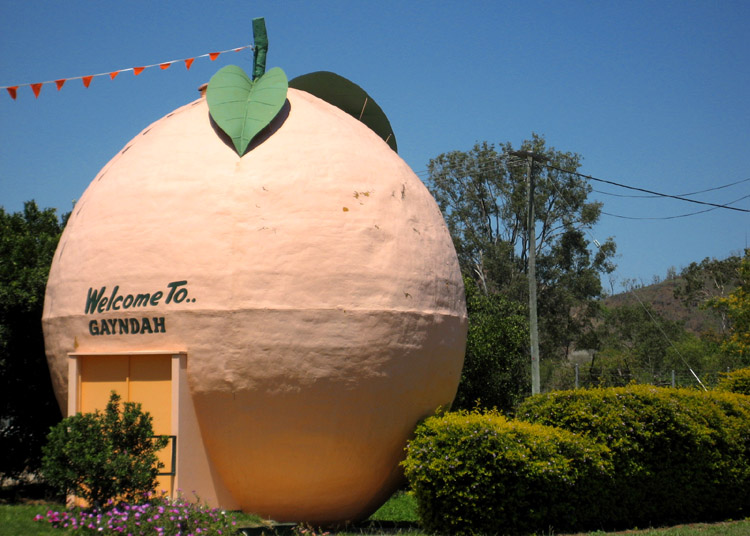
caption = The Big Orange, south of the town centre on the Burnett Highway
lga = North Burnett Regional Council
postcode = 4625
pop = 1,745
pop_footnotes =
est = 1849
elevation= 106
maxtemp = 28.2
mintemp = 13.6
rainfall = 766.9
stategov = Callide
fedgov = Flynn
dist1 = 328
location1=Brisbane
dist2 = 150
location2=Maryborough
dist3 = 163
location3= Bundaberg

Gayndah (postcode : 4625) is a town located on the Burnett River in Queensland, Australia. It is 366 kilometres north of the state capital, Brisbane, and 145 kilometres west of the regional city of Maryborough. The Burnett Highway passes through the town. At the 2006 census, Gayndah had a population of 1,745.Census 2006 AUS
id=UCL322000
name=Gayndah (Urban Centre/Locality)
accessdate=2007-10-25
quick=on
]

History

Exploration of the Gayndah area began in 1843. The first European settlers arrived in 1848, and the town was established in the following year. Agriculture and grazing have been the dominant industries of the area. The town is now the centre of Queenslands largest citrus growing area. The Gayndah Orange Festival is held every two years to celebrate this industry.

Gayndah was considered for the capital of Queensland, but lost to Brisbane because the river was not deep enough, thus making it impossible for large cargo ships to unload near the city. Fact|date=February 2007Gayndah is also the oldest official town in Queensland. The explorers Archer and Burnett establishing it in 1849. Fact|date=February 2007

Gayndah is Aboriginal for thunder. Fact|date=February 2007

Trivia

The town clock was donated by Mr. Richard Apel Esq., a local pastoralist. Fact|date=February 2007

In 1872, the town was the location where the hoax fish "Ompax spatuloides" was supposedly procured.

Duel Miles Franklin Literary Award winner Jessica Anderson was born in Gayndah

[http://www.rachelkoster.com Rachel Koster] , an independent Australian Singer/Song writer, is from Gayndah. [http://www.abc.net.au/widebay/stories/s2059584.htm]

References


Wikimedia Foundation. 2010.

Игры ⚽ Нужно сделать НИР?

Look at other dictionaries:

  • Gayndah — Staat …   Deutsch Wikipedia

  • Gayndah — Administration Pays …   Wikipédia en Français

  • Queensland Rugby League Wide Bay Division — The Wide Bay Division of the Queensland Rugby League is responsible for administering the game of rugby league in the Wide Bay area of Queensland. The Wide Bay Bulls had previously represented the division in the 1980 s and 1990 s in the Winfield …   Wikipedia

  • Construction of Queensland railways — Queensland s railway construction begin in the 1860s. A narrow gauge railway was selected due to cost savings and its suitability to the mountainous terrain along Queensland s coast. The rail network continued to expand until road transport… …   Wikipedia

  • 2010–2011 Queensland floods — he roof of her car awaits rescue during the Toowoomba flash flood …   Wikipedia

  • Mundubbera, Queensland — Infobox Australian Place | type = town name = Mundubbera state = qld caption = lga = North Burnett Regional Council postcode = 4626 pop = 1,053 pop footnotes = est = elevation= maxtemp = mintemp = rainfall = stategov = Callide fedgov = Flynn… …   Wikipedia

  • Shire of Gayndah — Infobox Australian Place | type = lga name = Shire of Gayndah state = qld imagesize= 135 caption = Location within Queensland pop = 2,911 pop footnotes = (2006 census) [Census 2006 AUS | id = LGA33300 | name = Gayndah (S) (Local Government Area)… …   Wikipedia

  • Comté de Gayndah — 25°37′29.53″S 151°36′28.53″E / 25.6248694, 151.607925 …   Wikipédia en Français

  • List of schools in Queensland — According to the Education Queensland website, there are, or have been, at least 2185 registered schools in Queensland.Fact|date=June 2007 List of Major Schools A * Aitkenvale State School (Government School) * Albany Creek State High School… …   Wikipedia

  • Local Government Areas in Queensland — Karte der Verwaltungsgebiete in Queensland nach März 2008 Der australische Bundesstaat Queensland ist seit 17. März 2008 nur noch in 53 lokale Verwaltungsgebiete (Local Government Areas) unterteilt. Inhaltsverzeic …   Deutsch Wikipedia

Share the article and excerpts

Direct link
Do a right-click on the link above
and select “Copy Link”