- Amersham
-
Coordinates: 51°40′37″N 0°36′12″W / 51.6769°N 0.6034°W
Amersham 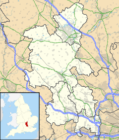
 Amersham
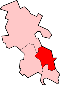
Amersham shown within BuckinghamshirePopulation 17,719 [1] OS grid reference SU965985 District Chiltern Shire county Buckinghamshire Region South East Country England Sovereign state United Kingdom Post town AMERSHAM Postcode district HP6 and HP7 Dialling code 01494 Police Thames Valley Fire Buckinghamshire Ambulance South Central EU Parliament South East England UK Parliament Chesham & Amersham List of places: UK • England • Buckinghamshire Amersham is a market town and civil parish within Chiltern district in Buckinghamshire, England, 27 miles north west of London, in the Chiltern Hills. It is part of the London commuter belt.
Amersham is split into two distinct areas: Old Amersham, set in the valley of the River Misbourne, which contains the 13th century parish church of St. Mary's and several old pubs and coaching inns; and Amersham-on-the-Hill, which grew rapidly around the railway station in the early part of the 20th century.
Contents
History
Records date back to pre-Anglo-Saxon times, when it was known as Egmondesham, and by the time that the Domesday Book was written around 1086 it had become known as Elmodesham. The Domesday entry is as follows:
- Geoffrey de Mandeville holds Amersham. It answers for 7½ hides. Land for 16 ploughs; in lordship 2 hides; 3 ploughs there. 14 villagers with 4 smallholders have 9 ploughs; a further 4 possible. 7 slaves; meadow for 16 ploughs; woodland 400 pigs. The total value is and was £9; before 1066 £16. Queen Edith held this manor.
Queen Edith was the wife of Edward the Confessor and sister of king Harold, and after her death in 1075 the land passed to William the Conqueror who granted it to Geoffrey de Mandeville.
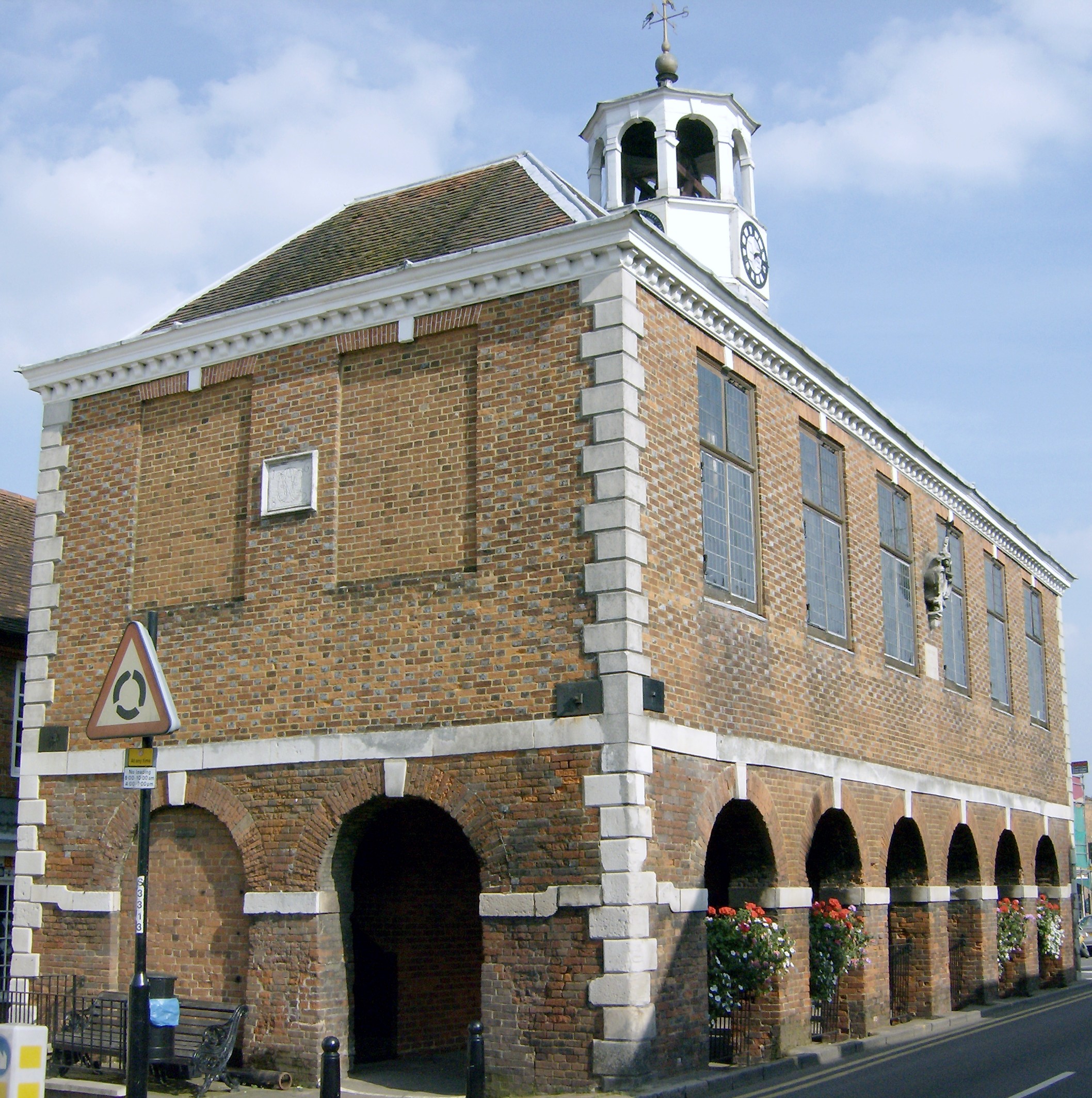
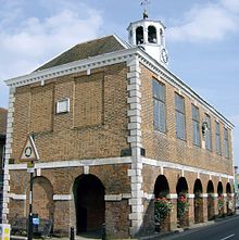 The 1682 Market Hall in Old Amersham
In 1200 Geoffrey, Earl of Essex obtained a charter for Amersham allowing him to hold a Friday market and a fair on 7 and 8 September. In 1613 a new charter was granted to Edward, Earl of Bedford, changing the market day to Tuesday and establishing a statute fair on 19 September.[2]
In 1521 seven Lollard dissenters (William Tylsworth, John Scrivener, Thomas Barnard, James Morden, Robert Rave, Thomas Holmes and Joan Norman) were burned at the stake in Amersham[citation needed] A memorial to them was built in 1931 and is inscribed as follows: "In the shallow of depression at a spot 100 yards left of this monument seven Protestants, six men and one woman were burned to death at the stake. They died for the principles of religious liberty,for the right to read and interpret the Holy Scriptures and to worship God according to their consciences as revealed through God's Holy Word". The Universal Magazine of September 1749 (p139) quotes that 'William Tylesworth' was in fact burnt in 1506, and that Thomas Bernard and James Morden, a labourer, were burnt about two years later[citation needed]
The area of the town now known as Amersham on the Hill was referred to as Amersham Common until after the arrival of the Metropolitan Line in 1892. After this date growth of the new area of the town gradually accelerated, with much work being done by the architect John Kennard. It is now known locally as "Top Amersham","the Top Town" or "the New Town".
Governance
Amersham sent two MPs to the unreformed House of Commons from 1625, and was considered a rotten borough until the Reform Act 1832 stripped it of its representation. The town was then part of the county constituency of Buckinghamshire. From 1885 it was in the Aylesbury constituency, in 1950 it formed part of the South Buckinghamshire seat and in 1974 the current Chesham and Amersham constituency was created. Since then Ian Gilmour (1974–1992) and then Cheryl Gillan have represented the constituency on behalf of the Conservative party. In the 2005 General Election Ms Gillan was returned with 54.4% of the vote. Amersham is represented by its own town council. It is a civil parish within Chiltern district and represented as such on the Buckinghamshire County Council.
Geography
Amersham is located at 51°40′00″N 00°38′00″W / 51.6666667°N 0.6333333°W (51.6667, -0.6333)1. Old Amersham is situated on the valley floor of the River Misbourne. This is a chalk stream which dries up periodically. The river occupies a valley much larger than it is possible for a river the size of the present River Misbourne to cut, making it a misfit stream. The valley floor is at around 100m OD, while the valley top is at around 165m OD. It is likely that the valley was formed under conditions akin to those required to form a dry valley. Amersham on the Hill is built on the north side of the Misbourne valley, on a small plateau that forms the watershed between the Misbourne and the neighbouring River Chess.
Transport
Railway
Amersham is linked to London by the Metropolitan Line of London Underground and is the last station on the Metropolitan main line. Much of this line is shared with the mainline railway service, which runs from Marylebone to Aylesbury. The town features in the 1973 John Betjeman (1906–1984) documentary Metroland about the growth of suburban London in the 20th century. The construction of the railway line was controversial at the time and objections from local landowners prevented its construction until 1892. The station was built a mile to the north of the old market town and has provided the focus of Amersham on the Hill ever since.[3] Chiltern Railways share the railway track with London Underground and run services from Marylebone to Aylesbury Vale Parkway that pass through Amersham every day.
HS2
In March 2010, the Government announced the preferred route of the proposed High Speed Railway, HS2, non-stop from London to Birmingham.[4] A campaign of opposition to the impact on the town and the surrounding area of the preferred route is being locally co-ordinated by a protest group, Amersham Action Group, which along with other protest groups is part of the HS2 Action Alliance [5]
Roads
The town is located at the junction of the A355 road from Slough and Beaconsfield, the A404 road that links Maidenhead, High Wycombe and Harrow, the A416 road from Chesham and Berkhamsted and the A413 road, which runs from Aylesbury to Uxbridge.
Economy
Early trade at Amersham Market was in local grain, much of which was sold to London merchants. During the 17th century and 18th century a key industry in the town was brewing. After a number of changes of hands during this time William Weller of High Wycombe purchased the brewery in 1775. He, and his heirs, expanded the business by buying a number of local public houses during the next 150 years. In 1929 Gerrard Weller sold the brewery and 133 tied public houses to Benskins of Watford for £360,000, a move that led to the end of brewing in Amersham.[2] In addition to brewing, tanning, lace manufacture and brickmaking all had a prominent place in the manufacturing past of the town. During World War II, the Radiochemical Centre, a scientific research establishment, arrived in the town. This became Amersham International, then Amersham plc, and now, after a number of changes of ownership and name, is part of GE Healthcare.[6]
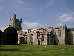 St Mary's Church, Old Amersham
Places of worship
Amersham on the Hill has a Free church, the Methodist church St. John's and the Church of England St Michael & All Angels. Old Amersham includes the Church of England St Mary's Church (a Grade I listed building since December 1958), the exterior is Victorian but it includes 17th century glass from Lamer Manor in Hertfordshire and monuments in the chancel to 17th and 18th century notables. Also in the town there is also a Quaker meeting house, a Methodist church and The King's Church a Baptist church.
Education
There are two secondary schools located in Amersham; Dr Challoner's Grammar School a grammar school for boys and the Amersham School a secondary modern school (more usually referred to as a community school). Additionally, Amersham is included in the catchment areas of both Dr Challoner's High School, a grammar school for girls, located in Little Chalfont, and Chesham Grammar School, a co-educational grammar school in Chesham.
The Dr Challoner's schools share a common foundation dating back to 1624 when the grammar school (then for boys only) started in Old Amersham. Dr Challoner's Grammar School moved to its present site in Amersham-on-the-Hill in 1905 when it became co-educational. In 1937 the school was incorporated` into the state system. After rapid growth it was decided to establish Dr Challoner's High School for Girls in nearby Little Chalfont in 1962 and Dr Challoner's Grammar School reverted to being for boys only.
Amersham School opened on its current site in 1964 as the Brudenell County Secondary School for girls. Following the closure of the Raans County Secondary School for boys in 1992, Brudenell became co-educational and was renamed Amersham School.
Amersham is served by several primary schools, including Our Lady's Roman Catholic Primary, Chestnut Lane School, Elangeni School, Chesham Bois Church of England School, St. Mary's Church of England Primary School, St. George's Church of England Infant School and Woodside Junior School.
There are two private preparatory schools: The Beacon School (boys) and Heatherton House (girls).
Amersham is also served by Amersham & Wycombe College for further education.
Sport and recreation
Amersham has a King George's Field in memorial to King George V. Near the playing field is the "Chiltern Pools", one of the three venues used by the Amersham Swimming Club.[7] The Chiltern Pools complex also contains The Climb, an indoor climbing wall, unique to the region. Chiltern Pools consists of three swimming pools, including a 25 metre main pool, a fun poolwith three water slides and a diving pool with a moveable floor to allow all ages to progress in swimming ability. Chiltern Pools also includes a large gym facility with cardiovascular and weights equipment. Since 2007 a third generation muga with synthetic grass allows all year play.
Amersham Town F.C. and Tokyngton Manor F.C. play football at Spratley's Meadow in Old Amersham, while various football teams use council facilities at Hervines Park (Amersham on the Hill) and Barn Meadow (Old Amersham).
Situated also at the Barn Meadow site, (School Lane, Old Amersham) is the 61 Judo Club, a family-oriented, successful and competitive Judo Club catering for serious and social players alike. It has currently (2011) over 80 active members, and has provided several members of recent British Junior, Senior and Masters squads.
Hervines Park and Barn Meadow host some cricket in the summer, but the main cricket clubs in the town are Amersham Cricket Club who play in the grounds of Shardeloes and Amersham Hill Cricket Club. Amersham and Chiltern Rugby Football Club play rugby union at Weedon Lane in Amersham on the Hill. The Chiltern Harriers Athletics Club is the local athletics club. Amersham and Chalfont Hockey Club is the local hockey club based at Buckinghamshire New University.
Town partnerships
 Bensheim in Germany (since 1977)
 Krynica-Zdrój in Poland
Film, books and television
The town has been used in a number of films, including:
- The Duke Wore Jeans (1958)
- Carve Her Name with Pride (1958)
- Circus of Horrors (1960)
- Murder at the Gallop (1963)
- The Jigsaw Man (1983)
- The Shooting Party (1985)
- Four Weddings and a Funeral (1994)
- Metroland (1997)
Television programmes filmed in the town include:
- Metro-land (TV) (1973)
- Midsomer Murders (seven episodes)[8]
- The Peter Principle (1990s)
- Chucklevision (one episode) (1990's - 2000's)
Books featuring the town include:
- George Orwell's Nineteen Eighty Four (briefly)
- Douglas Adams & John Lloyd The Meaning of Liff (briefly, as Definition)(1984)
Notable people
- Ruth Ellis, last woman hanged in England, buried in St Mary's Church
- Arthur Machen, resident in Amersham
- Tim Rice, born in Amersham
- Eddie Howe, Burnley FC manager, born in Amersham
External links
- [2]
- Amersham news, views & information
- Amersham Town Council
- Chiltern District Council
- Saint Mary's Church, Old Amersham
- Amersham Free Church
- St. John's Methodist Church
- King's Church
- Amersham Field Centre
- Amersham Deanery : in the Diocese of Oxford
- Amersham Cricket Club
- Amersham Hill Cricket Club
- Chiltern Harriers Athletics Club
- Amersham Band
- Rotary Club of Amersham
- Chiltern District news
- www.geograph.co.uk : photos of Amersham and surrounding area
References
- ^ Neighbourhood Statistics 2001 Census
- ^ a b Hunt, J (2001). A History of Amersham. Phillimore. ISBN 1-86077-187-4.
- ^ Coppock, JT (1962). The Chilterns. The Geographical Association.
- ^ High Speed Rail Department of Transport, Accessed 25-11-2010
- ^ Table HS2 Action Alliance Affiliated Groups, Accessed 25-11-2010
- ^ Britain's richest towns: 10 - 1 Telegraph online 19 April 2008 Retrieved, 2009-07-10
- ^ Amersham Swimming Club
- ^ Midsomer Murders Locations [1] Retrieved on March 6, 2007. Archived 2009-10-25.
Chiltern District Towns
(Component Areas
and Hamlets)Amersham (Woodrow) • Chesham (Botley, Chesham Vale, Chessmount, Codmore, Great Hivings, Hilltop, Lye Green, Newtown, Orchard Leigh, Pednormead End, Pond Park, Waterside)
Other Civil Parishes
(Component Villages
and Hamlets)Ashley Green (Ashley Green, Whelpley Hill) • Chenies • Chalfont St Giles (Bottrells Close, Chalfont Grove, Chalfont St Giles, Jordans, Stratton Chase) • Chalfont St Peter (Austenwood, Chalfont Common, Gravel Hill, Layters Green) • Chartridge (Asheridge, Bellingdon, Chartridge, Hundridge, Pednor, Pednor Bottom) • Chesham Bois • Cholesbury-cum-St Leonards (Buckland Common, Cholesbury, Hawridge, St Leonards) • Coleshill • Great Missenden (Ballinger, Ballinger Bottom, Ballinger Common, Bryant's Bottom, Frith-hill, Great Missenden, Heath End, Hotley Bottom, Hyde End, Little Wood Corner, Mobwell, Prestwood, South Heath) • Latimer (Latimer, Ley Hill, Tyler's Hill) • Little Chalfont • Little Missenden (Beamond End, Holmer Green, Hyde Heath, Little Kingshill, Little Missenden, Mantles Green, Mop End, Spurlands End) • Penn (Beacon Hill, Forty Green, Knotty Green, Penn, Penn Bottom, Penn Street, Winchmore Hill) • Seer Green • The Lee (Lee Clump, Lee Common, Lee Gate, Hunt's Green, Swan Bottom, The Lee)Former Districts
and BoroughsFormer
ConstituenciesCeremonial county of Buckinghamshire Unitary authorities Boroughs or districts Major settlements Amersham · Aylesbury · Beaconsfield · Buckingham · Chesham · High Wycombe · Marlow · Milton Keynes (including Bletchley, Fenny Stratford, Stony Stratford, Wolverton) · Newport Pagnell · Olney · Princes Risborough · Wendover · Winslow · Woburn Sands
See also: List of civil parishes in BuckinghamshireRivers Topics Boundary changes · Grade I listed buildings · High Sheriff · History · Lord Lieutenant · Monastic houses · Museums · Parliamentary constituencies · Places · Places of interest · Railways · Schools (Bucks) · Schools (Milton Keynes) · Sites of Special Scientific Interest · TransportCategories:- Amersham
- Towns in Buckinghamshire
- Market towns in Buckinghamshire
- Civil parishes in Buckinghamshire


Wikimedia Foundation. 2010.