- North Walsham & Dilham Canal
-
North Walsham and Dilham Canal Canal 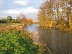
Country England State Norfolk Region East of England District North Norfolk Source begins Swafield Bridge Mouth Merges with the River Ant Length 8.7 mi (14 km) watermills
Briggate Mill
Ebridge Mill
Bacton Wood
Swafield Mill
Antingham Bone MillsNorth Walsham and Dilham Canal Legend

Antingham Ponds 

Terminus 
Antingham Mill Pond 


Bradfield bridge Bradfield Broad 
Swafield upper lock Swafield lower lock 
Swafield bridge Royston bridge 


Bacton Wood lock and mill Anchor Road bridge 


Ebridge lock Ebridge Mill 

Meeting House Staithe Briggate lock Briggate Mill 


Honing Staithe Honing bridge Honing lock 
East Ruston 
East Ruston branch Tonnage bridge 
Dilham Staithe 

Tylers Cut 

Smallburgh River Jn 
Wayford bridge 
River Ant The North Walsham and Dilham Canal is a waterway in the English county of Norfolk. It is accepted officially that this waterway is the only canal in Norfolk although it is the canalization of the upper reaches of the River Ant. This navigation was constructed with locks a little wider than most canals in the UK to accommodate the use of the Norfolk wherries. It is 8.7 miles (14.0 km) long and runs from Swafield Bridge to a junction with the River Ant at Smallburgh.
Contents
History
The River Ant was navigable to Dilham prior to 1810, when consideration was given to extending navigation northwards along the course of the river. Plans were drawn up by William Youard and John Millington in 1811 and it was Millington's plan that formed the basis of a bill presented to Parliament in early 1812. It was opposed by the inhabitants of Worstead and Dilham, who feared that their businesses would collapse if boats could reach North Walsham, but the navigation was nevertheless authorised by an Act of Parliament dated 5 May 1812,[1] which created the Company of Proprietors of the North Walsham and Dilham Canal Navigation. They had powers to raise £30,000 by the issuing of shares, and a further £10,000 if required, either from shares or by mortgage.[2] Work on the canalisation of the River Ant did not start until 1825,[3] with some of the delays caused by a claim for damages made by Issac Harris Lewis, who owned his own staithe at Dilham and felt that the new canal would damage his trade. His case was heard in April 1825 and he was awarded £1,500 in compensation. Work began in the same month, employing 100 men from Bedfordshire.[1]
The canal was designed by John Millington, who acted as engineer for the project, although the actual construction was carried out by Thomas Hughes, who had previously worked on the construction of the Caledonian Canal, the Dingwall Canal and the Union Canal, all in Scotland. Millington came from Hammersmith in London. The North Walsham and Dilham Canal was his only canal-building venture. Later in his career he went to the United States of America and wrote Elements of Civil Engineering which includes much information on canal building.[4]
The design of the canal included six locks to raise the level by 58 feet (18 m) along its 8.2-mile (13.2 km) length. The locks were sized for wherries, which were 50 by 12.3 feet (15 by 3.7 m). Vessels were able to reach Cubbitt's Mill by 14 June 1826 and the canal was formally opened on 29 August 1826. The water supply for the canal came from the ponds at Antingham, but the link into the ponds could only be used by small lighters, as it was not deep enough to be used by wherries. Consequently, they used a basin next to Antingham Mills. Tolls on all cargoes using the canal were collected at Tonnage Bridge, where there was once a wharf and a cottage.[5]
Operation
The main use of the canal was to carry offal to the two Antingham Bone Mills, although other cargoes were carried such as manure, flour, grain, coal and farm produce. A profitable trade in coal did not develop, as the tolls were too high and it was cheaper for coal to be brought down the coast from the north east and landed on the beach near Bacton or Mundesley, from where it would reach North Walsham by cart. Later, the railways handled most of the coal traffic. Most of the vessels using the canal were wherries, which had a draught of 3 feet (0.91 m) and were capable of carrying between 18 and 20 tons. Some wherries were of a slip-keel design, where the keel of a loaded boat could be unbolted from the bottom of the vessel while it was afloat, in order to negotiate the shallow waters of the canal. Once unloaded, the keel would be replaced, to allow more sail to be used. While detached, the keels were towed behind the boat, to prevent them from drying out and warping. A smaller 12-ton wherry regularly carried vegetables between Antingham and Great Yarmouth and was known as the cabbage wherry.[6]
Decline
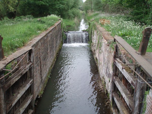
 The disused canal at Briggate
The canal was not a financial success, and in 1866 the company obtained an act of Parliament that would allow them to sell the canal providing three-quarters of the shareholders agreed. In 1885, they decided to use this power, as Edward Press, the owner of Bacton Wood mill, and a trader with a fleet of wherries, wished to purchase it. The sale was completed on 16 March 1886, on the understanding that the £600 price would be distributed to the shareholders. Holders of 446 of the original 586 shares were traced, but after paying money on 55 shares, James Turner, the London solicitor handling the sale, absconded with the rest of the fund. The proprietors felt morally bound to refund the money themselves, but did not do so immediately, as none of the shareholders made a claim. Eventually in 1896, five of them, including Press who had bought the canal, contributed £110 17s 7d (£110.88) to a fund which was distributed as a dividend to those who had not been paid.[7]
In 1887, Walter Rye was appointed as the clerk and noticed a number of irreguarities in the way the company ran. Edward Press was the general manager, although he was disqualified from the post as he profited from the canal, and there was no treasurer, despite the fact that the enabling act required one to be appointed. There was also no way to wind up the company. Rye's concerns were ignored, as nothing changed, and Press continued to run the canal. In 1893, the upper 1.4 miles (2.3 km) from Swafield lock to Antingham were abandoned, but traffic figures for 1898 show that 6,386 tons arrived at wharves on the canal, 5,000 tons were loaded for shipping, and 400 tons were carried within the confines of the canal. Trade declined steadily and Press died on 2 July 1906. A director of the General Estates Company bought the canal at an auction held on 11 September 1907, for £2,550.[7]
Heavy flooding in August 1912 washed away several staithes, and resulted in a breach of the canal bank above Bacton Wood Lock. The canal was bought by G Cubitt and G Walker in 1921, who immediately formed the North Walsham Canal Co Ltd, which bought the canal for the £1,500 they had paid.[8] Some attempts were made to dredge the channel below Swafield locks in the 1920s, but the section above Swafield Bridge was abandoned in 1927 and has reverted to farmland.[3] The wherry "Ella" made the final trading journey on the canal from Bacton Staithe in 1934.[8]
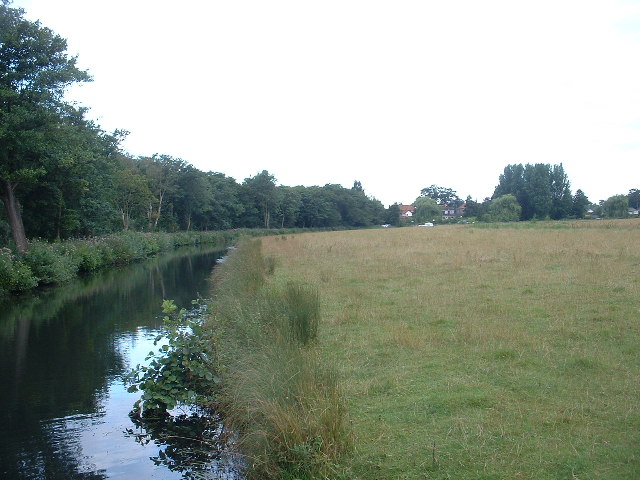
The canal today
 Tonnage Bridge
 Tyler's Cut at Dilham
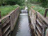
 The lock at Honing
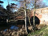
The canal was never nationalized and continued to belong to the North Walsham Canal Company.[3] The canal is only navigable for the first 2 miles (3.2 km) from the Smallburgh end, up to Honing lock. There are moves to restore the canal and at present there is work going on to restore the bottom lock. The East Anglian Waterways Association has undertaken a detailed environmental survey of the canal and engineering studies on lock restoration and other technical matters and with help from the North Walsham and Dilham Canal Trust, has held regular work parties at Honing, Briggate and Ebridge Locks, to clear encroaching trees.[9] Further north, both Bradfield Bridge[10] and the bridge that carries Anchor Road over the canal at Bacton Wood Mill are grade II listed structures.[11]
Some 2.25 miles (3.62 km) of the route, consisting of the pound above Bacton Wood lock, the lock itself, the pound below it and Ebridge Lock, were sold to the Old Canal Company in 2009, who intend to re-water this section. Work has concentrated on the lock at Bacton Mill, where reinstated water levels will enable the mill (which has been restored by its owner) to operate once more.[12]
The residents of North Walsham made ten mosaics for the Millennium celebrations, one of which shows a Norfolk wherry.[3]
Locks and Watermills
Point Coordinates
(Links to map resources)OS Grid Ref Notes Antingham Ponds 52°50′33″N 1°21′38″E / 52.8424°N 1.3605°E TG264325 Original head of navigation Bradfield Bridge 52°50′15″N 1°22′28″E / 52.8376°N 1.3745°E TG273320 Swafield Bridge 52°50′12″N 1°23′35″E / 52.8366°N 1.3930°E TG286319 7.3 miles. Swafield Mill[13] Austin Bridge 52°49′52″N 1°24′33″E / 52.8310°N 1.4092°E TG297313 6.5 miles Bacton Wood lock (No 4) 52°49′28″N 1°24′39″E / 52.8245°N 1.4109°E TG299306 6.0 miles. Bacton Wood Mill[14] Spa Common bridge 52°49′26″N 1°24′41″E / 52.8239°N 1.4115°E TG299306 5.9 miles Ebridge lock (No 3) 52°48′57″N 1°25′42″E / 52.8159°N 1.4282°E TG311297 5.0 miles. Ebridge Mill[15] Meeting Hill Branch junction 52°48′17″N 1°25′24″E / 52.8047°N 1.4233°E TG308285 4.1 miles Briggate lock (No 2) 52°47′42″N 1°26′00″E / 52.7949°N 1.4333°E TG315274 3.3 miles. Brigate Mill[16] Honing Common bridge 52°47′33″N 1°27′04″E / 52.7926°N 1.4511°E TG327272 2.6 miles Honing lock (no 1) 52°47′26″N 1°27′22″E / 52.7906°N 1.4560°E TG331270 2.1 miles East Ruston Branch canal 52°47′19″N 1°28′31″E / 52.7885°N 1.4753°E TG344268 1.3 miles Tonnage Bridge, Dilham 52°46′52″N 1°28′46″E / 52.7811°N 1.4794°E TG347260 0.9 miles Dilham Dyke junction 52°46′16″N 1°28′30″E / 52.7712°N 1.4751°E TG345249 0.4 miles Smallburgh junction with River Ant 52°46′14″N 1°28′54″E / 52.7705°N 1.4817°E TG349248 0.0 miles See also
Bibliography
- Boyes, John; Russell, Ronald (1977). The Canals of Eastern England. David and Charles. ISBN 0-7153-7415-X.
- Cumberlidge, Jane (2009). Inland Waterways of Great Britain (8th Ed.). Imray Laurie Norie and Wilson. ISBN 978-1-84623-010-3.
- Priestley, Joseph (1831). "Historical Account of the Navigable Rivers, Canals, and Railways, of Great Britain". http://www.jim-shead.com/waterways/sdoc.php?wpage=PNRC0481#PNRC477.
References
- ^ a b Boyes & Russell 1977, pp. 126–127
- ^ Priestley 1831, p. 477
- ^ a b c d Cumberlidge 2009, pp. 227–228
- ^ Boyes & Russell 1977, pp. 127–128
- ^ Boyes & Russell 1977, pp. 128–129
- ^ Boyes & Russell 1977, pp. 129–130
- ^ a b Boyes & Russell 1977, pp. 130–131
- ^ a b Boyes & Russell 1977, p. 132
- ^ "North Walsham and Dilham - Updates". East Anglian Waterways Association. http://www.eawa.co.uk/walsham.html.
- ^ Details from listed building database (222769) Bradfield Bridge. Images of England. English Heritage.
- ^ Details from listed building database (222759) Anchor Road Bridge. Images of England. English Heritage.
- ^ Waterways, The journal of the Inland Waterways Association, Issue 227, Spring 2010
- ^ "Swafield Mill". Norfolk Mills. http://www.norfolkmills.co.uk/Watermills/swafield.html.
- ^ "Bacton Wood Mill". Norfolk Mills. http://www.norfolkmills.co.uk/Watermills/bacton-wood.html.
- ^ "Ebridge Mill". Norfolk Mills. http://www.norfolkmills.co.uk/Watermills/ebridge.html.
- ^ "Briggate Mill". Norfolk Mills. http://www.norfolkmills.co.uk/Watermills/briggate.html.
External links
- Norfolk County Council E-Map Explorer | Briggate (part of tithe map, c. 1840) | Briggate (part of Ordnance Survey map, 1st Edition)
 Rivers and watercourses of NorfolkRiver Ainse (or Eyn) • River Ant • River Babingley • Beeston Beck • River Bure • River Burn • River Chet • River Cong • River Gadder • Gaywood River • River Glaven • River Great Ouse • Gur Beck • Hagon Beck • River Heacham • River Hor • River Hun • River Ingol • River Little Ouse • River Mun • River Nar • River Nene • North Walsham & Dilham Canal • Panford Beck • Penny Spot Beck • Scarrow Beck • Spring Beck • River Stiffkey • River Tas • River Tat • River Thet • River Thurne • River Tiffey • River Tud • River Waveney • River Wensum • Wisbech Canal • River Wissey • River YareAldborough Watermill • Bolwick Hall Watermill • Bintry Watermill • Buxton Watermill • Congham Oil Mill • Eade’s Watermill • Gimingham Watermill • Glandford Watermill • Gresham Watermill • Gunton Park Sawmill • Heacham Watermill • Hempstead Watermill • Kettle Watermill • Lenwade Watermill • Letheringsett Watermill • Letheringsett Brewery watermill • Mundesley Watermill • Narborough Bone Mill • Narborough Watermill • Sheringham Watermill • Snettisham Watermill • Weybourne WatermillCategories:
- Rivers of Norfolk
- Canals in England
- Transport in Norfolk


Wikimedia Foundation. 2010.