- River Ant
Infobox River
river_name = River Ant
caption = The River at How Hill
origin = Antingham Ponds,Norfolk . Grid ref: mmukscaled|TG257353|100|TG 257 353.
mouth =River Bure at Ant Mouth, south ofLudham Bridge , Norfolk. Grid ref: mmukscaled|TG375160|100|TF 375 160.
basin_countries =United Kingdom (England )
length = 27.3 km / 17 miles.The River Ant is a tributary river of the
River Bure inEngland . It is 17 miles long (of which 8.75 miles are now navigable), and has an overall drop of 25 meters from source to mouth. The rivers sources is just east of the village ofAntingham inNorth Norfolk at Atingham pools. Just below the pools the rivers route has been used as acanal in the past starting at what was Antingham bone mill. An Act of Parliament established theNorth Walsham & Dilham Canal in 1812, as a wide gauge canal able to take a Norfolkwherry . It was built at a cost of £ 30,000 and opened on July 25, 1826, making the river navigable all the way toDilham where the river widens and deepens for Navigable purpose. It carried manure, offal, flour, coal, and farm produce. In 1885, the canal was sold for £600, but the canal company's solicitor disappeared with the money. The flood of 1912 washed away several staithes. The wherry "Ella" made the final trading journey on the canal from Bacton staithe in 1934. The canal was never nationalised and still belongs to theNorth Walsham Canal Company. The river, now in its canal form, curves around the north east of the town ofNorth Walsham passingBacton Wood Mill. Below Bacton mill the canal reaches a lock at Ebridge mill. The lock is in poor condition but it is hoped that this section of canal will one day be restored and made navigable again. Further on at Briggate Bridge there is another mill and another disused lock.Norfolk Broads (The Broads Authority)
At Honing Bridge the course enters the
The Broads covered by The Broads Authority. Here the canals cuts through a marshy wooded area called Dilham Broad and again curves North East around the Village of Dilham passing under Tonnage Bridge. Below Tonnage Bridge are the last limits of theNavigation throughBroad fen before reverting back to the river. Just before Wayford Bridge there is a branch of thecanal that runs of to west called Tyler’s Cut. This branch links the villages ofDilham and Smallburgh to the river and the rest of the broads although this is at the moment only navigable by very small boats. AtWayford Bridge the river passes the Wayford bridge Hotel and its row of tiny house boats that line the east bank of the river there. There is only 8 feet of headroom under the bridge which carries theA149 road over the river. The river is only three feet deep at this point also making it only passable by the smallist of pleasure craft. Some years ago an ancient hard surface of a ‘ford’ was found on the river bed here, hence the name “Way- Ford”. Just the other side of the bridge there are boat yards on both banks and the river follows a fairly straight course until it reaches the photogenic “Hunsett Drainage Mill”. Here the river turns south and passes the channel leading to the staithe’s at Stalham and Sutton the river banks of Barton Fen are crowded with trees,marshes , and reeds, the latter once harvested and used for thatching for centuries past.Barton Broad
, the second largest broad. Its crystal clear waters are due to a lot of hard work and money spent in the last few years to clean the broad up. Barton broad is also unique in that it has an island called “Pleasure Hill”.
The last stretch
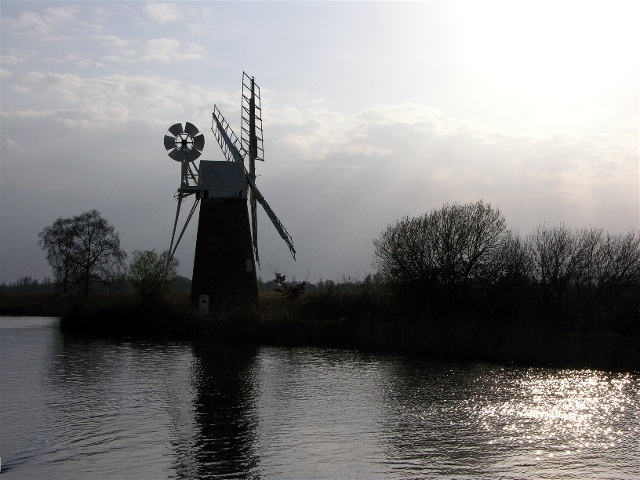
The river leaves the broad in the south east corner and enters a stretch called “The Shoals” all around this landscape you can see many drainage mills. Carrying on, the river twist and turn through the Broadland countryside passing the drainage mills of Clayrack and Broadman’s on the east bank, and Turf Fen
Drainage mill on the west bank. At this point the river passesHow Hill nature reserve which is well worth a visit. From here the river makes a wide horseshoe bend as it heads towardsLudham Bridge. The river passes under the bridge that carries the A1062 road, and then takes a sharp turn east before straightening out a little. The river then turns south and the Ant ends when it enters the river Bure at “Ant Mouth” close to the ruins St Benet’s AbbeyFacts
A special type of
Norfolk wherry was used on the Ant, measuring 50' x 12' max.The
Ant Broads & Marshes NNR is aNational Nature Reserve .The
North Walsham & Dilham Canal is the canalisation of the Ant and joins it atSmallburgh junction.External links
Wikimedia Foundation. 2010.