- Middle Level Navigations
-
Coordinates: 52°27′40″N 0°14′28″W / 52.461°N 0.241°W
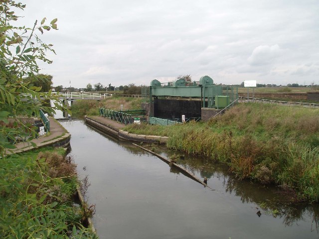
Middle Level Navigations The Mullicourt aqueduct where the Well Creek crosses the main drain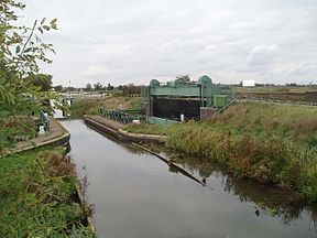
Original owner Bedford Level Commissioners Maximum boat length 80 ft 0 in (24.38 m) Maximum boat beam 11 ft 0 in (3.35 m) Start point Peterborough End point Salters Lode Connects to River Nene, River Great Ouse Locks 6 Status Navigable Navigation authority Middle Level Commissioners Middle Level Navigations Legend


River Great Ouse 

St Germans Pumping Stn 

Middle Level Main Drain 


Middle Level / EA boundary 
Salters Lode Lock 
River Gt Ouse Old Bedford Sluice 

Well Creek + Mullicourt Aqueduct 


Wisbech Canal 
Outwell 


Old Pophams Eau A1011 Three Holes bridge 
Marmount Priory Lock Popham's Eau 

Sixteen Foot River Old Bedford River 

Counter Wash Drain Welches Dam Lock 
Middle Level / EA boundary Horseway Sluice 
March Forty Foot River River Nene (old course) Twenty Foot River 
Ramsey Hollow bridge Flood's Ferry (Junction) Whittlesey Dike 
High Lode + Ramsey marina 
Lodes End lock Bevills Leam 
Ashline lock Tebbits Bridge Pumping Station 
Whittlesey New Dyke Kings Dyke 

Horsey Sluice (was a lock) Stanground Sluice River Nene Peterborough The Middle Level Navigations are a network of waterways in England, primarily used for land drainage, between the Rivers Nene and Great Ouse, between Peterborough and Cambridge.
Contents
History
The Middle Levels of the Fens are a low-lying area of approximately 270 square miles (700 km2), much of which is at or below sea level.[1] Attempts to protect them from inundation, and to make them suitable for agriculture began in 1480, when the Bishop of Ely, John Morton, constructed a 12-mile (19 km) straight cut from Stanground to Guyhirne, providing the waters of the River Nene with a more direct route to the sea than the previous route through Benwick, Floods Ferry, March, Outwell and Wisbech. Morton's leam, the name given to the medieval drainage ditch, was 40 feet (12 m) wide and 4 feet (1.2 m) deep, and much of the manual labour was provided by prisoners of war from the Hundred Years War.[2] In 1605, Sir John Popham, who was the Lord Chief Justice at the time, began work on a drainage scheme near Upwell, and although the scheme was ultimately abandoned in 1608, Popham's Eau, his 5.6-mile (9.0 km) cut from the old course of the River Nene near March to the Well Creek at Nordelph remains.[3] The next significant advance was in 1630, when the Dutch Engineer Cornelius Vermuyden was employed by the Earl of Bedford and others to drain the Fens. The Old Bedford River was cut from Earith to Salters Lode, a distance of 21 miles (34 km), and provided sufficient drainage that the land could be used for summer grazing. In 1650, he supervised the construction of the New Bedford River, running parallel to the Old, and the Middle Levels area was protected. The Forty Foot, Twenty Foot and Sixteen Foot Rivers were cut soon afterwards, to drain water from the area to Salters Lode and Welches Dam.[1]
Between 1824 and 1839, John Dyson Jr was employed as the resident engineer by the Beford Level Commissioners. He had been recommended by John Rennie, and was charged with the reconstruction of ten locks and sluices, together with "a great many other works of great importance", for which the estimated cost was between £50,000 and £60,000. The work included the rebuilding of Salters Lode sluice, which Dyson oversaw himself, as no suitable tenders were received when the work was advertised. It was completed by 1832.[4]
As the land dried, the peaty soils shrank, causing the land surface to drop. Much of the Middle Levels was flooded in 1841-2, and this led the Commissioners to obtain an Act of Parliament in 1844, which authorised the construction of a new main drain, 11 miles (18 km) long,[5] in order that water could flow by gravity to Wiggenhall St Germans, where the levels of the tidal river were about 7 feet (2.1 m) lower than at Salters Lode.[1] The work was completed in 1848.[5] In 1862 an Act of Parliament created the Middle Level Commissioners as a separate body to the Bedford Level Corporation, and they embarked on a series of improvements.[1] Drainage was always the primary function, but navigation was also important, and the new body had powers to charge tolls for the use of the waterways.
1862 was also the year in which the Wiggenhall sluice collapsed and around 9 square miles (23 km2) of the levels were flooded. Sir John Hawkshaw constructed a new sluice, consisting of a large cofferdam, with 16 tubes, each 3.5 feet (1.1 m) in diameter, which passed over the top of it. The top of these pipes was 20 feet (6.1 m) above the inlet and outlet, and an air pump was used to remove the air from them, so that the water would syphon over the cofferdam. It was the only time that such a solution was tried in the Fens, and it was supplemented in 1880 by a more conventional gravity sluice, also constucted by Hawkshaw, as it was unable to discharge sufficient water at high tides.[5]
Pumping Stations
By the early 1930s, gravity drainage was no longer adequate, as land levels continued to fall, and a new sluice and pumping station were constructed at St Germans, opening in 1934.[1] The sluice was built in the centre of the old syphon sluice channel, with a pumping station on either side of it. Three pump sets were installed, with space for a fourth. Each consisted of a 1,000 brake horsepower (750 kW) Crossley diesel engine coupled to an 8.5-foot (2.6 m) Gwynnes pump, which could pump 840 tons per minute (1234 Megalitres per day (Mld)). Once completed, the syphon sluice was demolished, while Hawkshaw's replacement sluice and its channel were abandoned.[5] The new works were paid for by a grant, given on condition that three quarters of the workforce were from the local area.[1] The capacity of the station was increased in 1951, when a 1,200 brake horsepower (890 kW) Crossley diesel engine was fitted into the spare bay, and again in 1969/70, when the two pumps on the north side of the sluice were rebuilt, and the engines replaced by 1,500 brake horsepower (1,100 kW) electric motors.[6] From 1977 to 1983, a series of improvements were carried out, which included the construction of a pumping station at Tebbits Bridge on Bevills Leam, and a lock at Lodes End. The banks of the Old River Nene were raised and clay puddling was used to retain the water, and major improvements to the Forty Foot, Twenty Foot and Sixteen Foot rivers were made, to maintain water levels for navigation. All of the bridges on the Sixteen Foot River were demolished and replaced to provide wider channels, and St Germans pumping station was again upgraded,[1] when the remaining 1934 engine was replaced by a 1,550 brake horsepower (1,160 kW) Allen diesel engine.[6] The improvements have restricted navigation in the lower south-western area, but greatly improved flood defences.
The Tebbitt's Bridge pumping station houses six Allen 39-inch (0.99 m) diameter pumps, each capable of pumping 260 Mld. Three of them are powered by 168 kW electric induction motors, manufactured by Lawrence Scott, which are controlled automatically, while the other three are powered by Dorman 274 bhp (204 kW) diesel engines, which are controlled manually. There is a standby generator, to cope with loss of the electric supply, and when all six pumps are operational, the station can pump 1586 Mld, equivalent to 18 tonnes a second.[7]
In April 1998, the St Germans pumping station ran at maximum capacity, which is 6134 Mld (or 71 tonnes a second), for over 50 hours,[8] and this led to the decision to replace it with a brand new installation, with 40% extra capacity. Work started in December 2006, and the pumping station, which includes the second largest pumps in Europe, includes a glass wall to enable visitors to see the pumps.[9] The new station was commissioned in February 2010, after which the old station was demolished.[10] There are more than one hundred smaller pumping stations scattered throughout the system to maintain the water levels and prevent flooding.[1]
Today
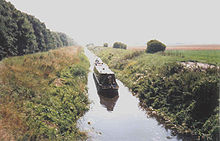 Passage on the Middle Level Navigations can be difficult. This is on Vermuyden's Drain between Horseway Lock and Welches Dam Lock
The navigations are managed by the Middle Level Commissioners, who are responsible for about 120 miles (192 km) of waterway, of which around 100 miles (160 km) are navigable.[11] The Commissioners are also responsible for six locks and a number of pumping stations, and are the fourth largest navigation authority in Great Britain.[12]
The navigations often form a short cut for boaters between the River Nene at Peterborough and the River Great Ouse at Salters Lode Lock. The suggested route passes through Stanground Sluice, along King's Dyke to Ashline Lock, and then along Whittlesey Dike to Flood's Ferry junction. From here the route is along the old course of the River Nene, passing through the twin villages of Outwell and Upwell, where the abandoned Wisbech Canal once formed a route back to the new course of the River Nene. The final stretch to Salters Lode lock is along Well Creek, passing over the top of the Middle Level Main Drain on Mullicourt Aqueduct.[13]
The alternative route via Horseway sluice and the Old Bedford River is problematic, as very low water levels between Horseway sluice and Welches Dam lock normally prevent passage.[13][14] This stands to be improved, however, as part of the Fens Waterways Link project.[15]
Access to other parts of the Levels was improved in 2006, when soldiers from the 53rd Field Squadron of the 39 Engineer Regiment raised the level of a Bailey bridge at Ramsey Hollow. This had previously restricted passage, as it was very low, but the exercise increased the headroom by 3 ft (0.9 m). The Inland Waterways Association raised the funding for the additional materials required, and the reconstruction opened up a 33-mile (53 km) cruising ring on the Levels.[16]
Boat sizes
When the navigations were built, the boats using them were traditional Fen Lighters, which were 46 by 11 feet (14 by 3.4 m), and the locks were sized accordingly. However, there has been a programme of increasing the lock sizes to make the waterways accessible to standard narrow boats. Lodes End lock was 65 feet (20 m) when built. The lock at Marmount Priory has been extended to 92 feet (28 m), Ashline lock to 90 feet (27 m), Stanground to 80 feet (24 m), and Horseway to 60 feet (18 m).[17] with the new Ashline lock being reopened on 1 April 1999.[13] Salter's Lode lock has three sets of gates, with a guillotine gate at the tidal end, and mitre gates which allow boats up to 62 feet (19 m) long to enter the River Ouse when the river level is higher than the level of Well Creek. It was possible for longer boats to pass straight through at certain states of the tide, but the lock has now been lengthened to 80 feet (24 m),[3] by the addition of a third set of mitre gates, facing away from the river, which can only be used when the level of the river is lower than that of the Creek. Welches Dam Lock is still sized for Fen Lighters, at just 47 feet (14 m) long.[17]
Bibliography
- Blair, Andrew Hunter (2006). Fenland Waterways of the Middle Level. Imray Laurie Norie and Wilson. ISBN 978-085288-994-7.
- Cumberlidge, Jane (2009). Inland Waterways of Great Britain (8th Ed.). Imray Laurie Norie and Wilson. ISBN 978-1-84623-019-3.
- Hinde, K. S. G. (2006). Fenland Pumping Engines. Landmark Publishing Ltd. ISBN 1-84306-188-0.
- Skempton, Sir Alec (2002). A Biographical Dictionary of Civil Engineers in Great Britain and Ireland: Vol 1: 1500 to 1830. Thomas Telford. ISBN 0-7277-2939-X.
- Sly, Rex (2003). From Punt to Plough - The History of the Fens. Sutton Publishing. ISBN 978-0-7509-3398-8.
- Page, William; Proby, Granville; Inskip Ladds, S., eds (1936). A History of the County of Huntingdon. Victoria County History. 3. pp. 249–290,'The Middle Level of the Fens and its reclamation'. http://www.british-history.ac.uk/report.aspx?compid=66187. Retrieved 30 December 2010.
References
- ^ a b c d e f g h "St Germans Pumping Station: History". Middle Level Commissioners. http://www.mlcpumping.info/History.html.
- ^ Sly 2003, p. 30
- ^ a b Blair 2006, p. 53
- ^ Skempton 2002, p. 201
- ^ a b c d Hinde 2006, pp. 38–40
- ^ a b Hinde 2006, pp. 40–42
- ^ Hinde 2006, p. 42
- ^ "St Germans Pumping Station: Why?". Middle Level Commissioners. http://www.mlcpumping.info/Why.html.
- ^ "St Germans Pumping Station: How?". Middle Level Commissioners. http://www.mlcpumping.info/How.html.
- ^ "'Pumping' Good News". Costain. http://www.costain.com/news/news-releases/2010/1/18/'pumping'-good-news.aspx. Retrieved 2010-05-21.
- ^ "About Us". Middle Level Commissioners. http://www.middlelevel.gov.uk/about-us.aspx. Retrieved 2011-06-22.
- ^ "Navigation". Middle Level Commissioners. http://www.middlelevel.gov.uk/aboutus.aspx?pid=3. Retrieved 2011-06-22.
- ^ a b c Jim Shead (1999) Middle Level Mysteries, article in Waterways World
- ^ Blair 2006, p. 29
- ^ "Fens Waterways Link overview". Inland Waterways Association. http://www.waterways.org.uk/waterways/waterway_restoration/eastern_region/fens_waterways_link/fens_waterways_link_overview. Retrieved 2011-06-22.
- ^ "Ramsey Hollow bridge raised". Inland Waterways Association. 10 December 2005. http://www.waterways.org.uk/regions_branches/eastern/Peterborough/raising_ramsey_hollow_bridge. Retrieved 2011-06-22.
- ^ a b Cumberlidge 2009, pp. 192–199
Categories:- Canals in England
- Drainage canals

Wikimedia Foundation. 2010.