- Chelmer and Blackwater Navigation
-
Chelmer and Blackwater Navigation The Navigation from Colchester Road, Maldon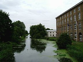
Original owner Chelmer and Blackwater Navigation Co Principal engineer John Rennie Other engineer(s) Richard Coates Date of act 1793 Date completed 1797 Maximum boat length 60 ft 0 in (18.29 m) Maximum boat beam 16 ft 0 in (4.88 m) Start point Chelmsford End point Heybridge, Maldon Connects to Blackwater estuary Locks 12 Length 13.75 miles (22.13 km) Status Navigable Navigation authority Essex Waterways Chelmer and Blackwater Navigation Legend

River Can 

Chelmsford 


River Chelmer 
Springfield Basin 

Weir 
1 Springfield Lock 


A138 road 

2 Barnes Mill Lock 


3 Sandford Lock A12 road 4 Cuton Lock 5 Stonham's Lock 6 Little Baddow Mill Lock Church Road 7 Paper Mill Lock North Hill 8 Rushes Lock 
River Ter 9 Hoe Mill Lock 
The Causeway 10 Rickets Lock 


River Blackwater 


Langford Mill 11 Beeleigh Lock 


Stop gates 

Beeleigh Mill 

A414 road A414 road Holloway Road 
Old course of Blackwater 
Maldon B1022 Colchester Road 12 Heybridge Sea Lock 

Blackwater estuary Northey Island The Chelmer and Blackwater Navigation is the canalisation of the Rivers Chelmer and Blackwater in Essex, in the east of England. The navigation runs for 13.75 miles (22.13 km) [1] from Springfield Basin in Chelmsford to the sea lock at Heybridge Basin near Maldon. It was opened in 1797, and remained under the control of the original company until 2003. It is now run by Essex Waterways Ltd, a wholly owned subsidiary of the Inland Waterways Association.
Contents
Geographical Information
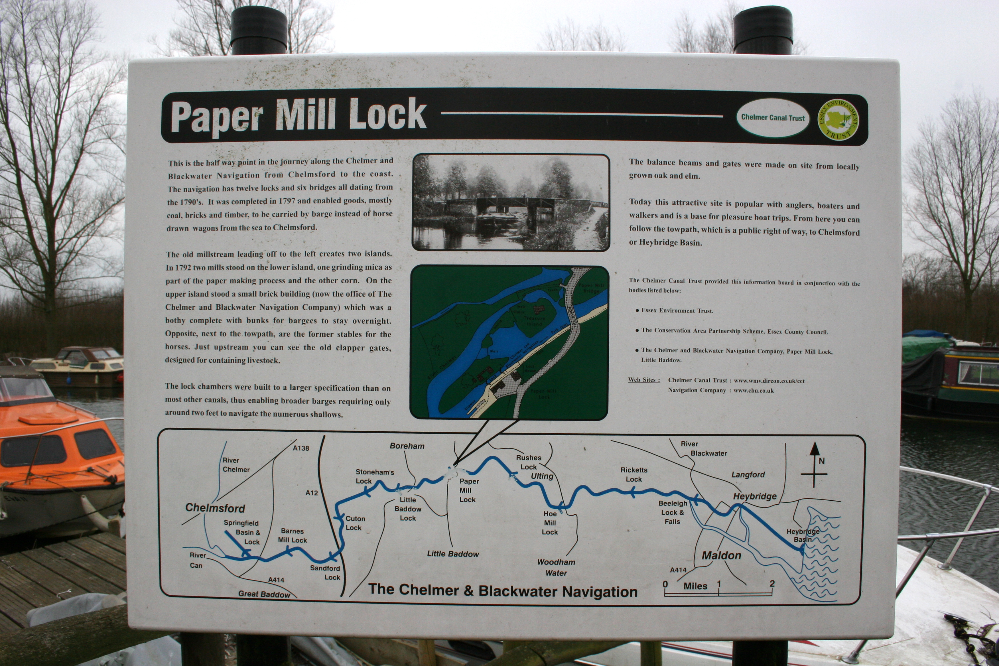
The navigation runs from Springfield Basin in Chelmsford to the sea lock at Heybridge Basin near Maldon. It has 13 locks, including a flood lock, six bridges and drops 23 metres (75.4 feet) from the basin to the sea.
History
Prior to the actual construction of the navigation, there had been almost 120 years of proposals for such a scheme, and opposition from the port of Maldon, which anticipated that its revenues would fall if vessels could travel to Chelmsford. The first such scheme was proposed in 1677 by Andrew Yarranton, who published his idea in a work entitled England's Improvements by Sea and Land. Maldon objected and the scheme came to nothing. In July 1733, John Hore, who was involved in the Kennet, Stroudwater, and the Avon Navigation at Bristol, proposed two schemes, one to make the river navigable, and another to create a new cut between Chelmsford and Maldon. Despite the projected extra costs for a canal, Hore favoured the canal scheme, as he believed there would be less objection from the millers along the river route. Maldon again objected on commercial grounds, and the scheme was dropped.[2]
The next schemes were proposed in 1762, when the canal engineers John Smeaton and Thomas Yeoman both carried out surveys for a possible route. Yeoman produced a second plan in 1765, and this was presented to Parliament. Yeoman had a high standing as a civil engineer, and the opponents to the scheme tried to engage a suitable engineer to counter the proposal, but many of the obvious choices,[3] including James Brindley,[4] declined because they were too busy. Eventually, Ferdinando and William Stratford took on the task, but both caught ague and fever, from which Ferdinando died, while William was ill for a year but then recovered.[3] An Act of Parliament to authorise the plan was passed on 6 June 1766, with the stipulation that the work must be completed within 12 years, and that no work could start until 25 per cent of the capital had been raised.[5] The scheme foundered because the required capital had not been subscribed.[3]
Peter Muilman called a meeting in Chelmsford on 2 October 1772, to propose improvements to the river, but a subsequent meeting decided that a new cut would be a better solution. Muilman announced that this scheme would probably not require any locks, and advocated that he should build it once Robert Whitworth had surveyed it, but nothing came of this. Finally in 1792, with navigations in other parts of the country bringing increased prosperity to the towns they served, the people of Chelmsford decide to avoid the opposition of Maldon by bypassing it, and terminating the navigation at Heybridge, on the River Blackwater below Maldon. Under the direction of John Rennie Charles Wedge surveyed the route in 1792 and Matthew Hall surveyed it in 1793. The new route would increase the length of the navigation by about 2 miles (3.2 km), but this plan formed the basis of a Parliamentary Bill. Despite spirited opposition by Maldon,[6] the bill became an Act of Parliament on 17 June 1793, creating The Company of the Proprietors of the Chelmer and Blackwater Navigation, with powers to raise £40,000 by the issuing of shares, and a further £20,000 if required.[5] Work started soon afterwards, and although John Rennie was officially Chief Engineer, the project was managed by Richard Coates, who had also assisted Rennie on the Ipswich and Stowmarket Navigation.[6] The grave of Richard Coates stands in Springfield churchyard, while Rennie's original survey book for the canal has been preserved.[7]
The port of Maldon now tried to mitigate their loss, and with advice from Benjamin Latrobe, produced a plan to improve the Blackwater through Maldon to its junction with the Chelmer at Beeleigh, which was submitted to Parliament in 1793. Realising that this would make the final cut to Heybridge redundant, the Navigation Company opposed the Bill, and it was defeated.[8] Latrobe submitted a revised scheme in April 1795, which was also defeated. This marked the end of his engineering career in Britain, as he emigrated to America shortly afterwards.[9] Work continued on the navigation, with the first section from Heybridge Basin to Little Baddow opening in April 1796 and the navigation opening throughout on 3 June 1797. The final cost was around £50,000.[8]
Operation
When completed, the length of the navigation was 13.8 miles (22.2 km). 12 locks lowered the level of the navigation by 75 feet (23 m) from Springfield Basin in Chelmsford to the sea lock at Heybridge Basin. An additional stop lock protected the new cut from flooding at Beeleigh. Here, the navigation left the course of the River Chelmer, and joined that of the River Blackwater, before entering the final 2.5 miles (4.0 km) of cut to Heybridge Basin. The waters of the River Blackwater were diverted into the Chelmer, flowing over a weir between Beeleigh Lock and the stop gates.[10] The navigation was constructed with only 2 feet (0.61 m) of water, which was the lowest statutory draught for any of the English commercial waterways. The locks were constructed to take barges which were 60 by 16 feet (18 by 4.9 m)[11] and each could carry around 25 tons. They were horse-drawn, and remained so until the 1960s, when diesel outboard motors were fitted. The only branch was a cut to Langford Mill, built privately by Mr Westcomb. It was well used until the 1870s, but was unused after 1881.[12]
There were teething problems, with floods in 1797 creating shoals which prevented the passage of barges. These got steadily worse, until Rennie was called back in 1799 to address the problem. Rennie was again recalled in 1805, when the mill owners complained about leakage through the locks and requested damages. Further improvements were made,[13] including the rebuilding of Heybridge sea lock by James Green,[14] and trade developed steadily. The first inland gasworks in Britain was built in Chelmsford in 1819, using coal brought up the navigation. Besides coal, bricks, stone, timber and general cargo was carried from Heybridge to Chelmsford, and the major cargo in the reverse direction was grain and flour. Local wharfs served the communities of Little Baddow, Boreham, Ulting and Heybridge.[13] At its peak in the mid 19th century, the canal was carrying over 60,000 tons of cargo per year.
Decline
The Eastern Counties Railway reached Chelmsford in 1843, and a branch line from Witham reached Maldon in 1848, but there was never a direct line between the two towns. Although trade declined, the impact of the railways was less significant than on many canals.[13] Following the Second World War, the sea lock into Heybridge Basin was extended to 107 by 26 feet (33 by 7.9 m), so that coasters carrying timber from the continent could enter the basin to transfer their cargo to barges. Traffic slowly declined until the last load of timber was delivered to Browns Yard (now Travis Perkins) on Springfield Basin in 1972. Although commercial traffic ceased, the navigation continued to derive income from water abstraction and from the sale of wood from the willows which grow along the banks. The willow is used for making cricket bats, and the trees were first planted in the 1880s when one of the directors saw the need for alternative sources of income.[11]
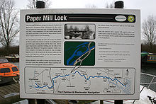 Sign at Paper Mill Lock
The navigation is unusual in that it was not nationalised in 1948 when most of the other waterways in the UK were, and remained under the control of the original Company of Proprietors of the Chelmer & Blackwater Navigation Ltd.[15]
The Leisure Era
Prior to the cessation of commercial traffic in 1972, pleasure craft were prohibited from using the locks,[2] but leisure use of the navigation was encouraged after that date. However, the Navigation Company was unable to pay its way, and went into administration in 2003. Although British Waterways were approached, they declined to take over the navigation. After negotiations with the Administrator, the Inland Waterways Association (IWA) signed a maintenance and operating agreement in November 2005 to take over responsibility for the running of the navigation through a wholly owned subsidiary called Essex Waterways Ltd.[16]
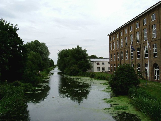
While Essex Waterways Ltd manage the navigation from day to day, it is still owned by the Company of Proprietors. The towpath from Maldon to Chelmsford has been designated as a public footpath, and is maintained in good order. Narrow boats can be hired from Paper Mill lock, and the infrastructure is being steadily upgraded. Access to the navigation from the River Blackwater is only possible at certain states of the tide, and advance booking to use the sea lock is required.[11]
Points of interest
Point Coordinates
(Links to map resources)OS Grid Ref Notes Chelmsford basin 51°43′53″N 0°28′53″E / 51.7315°N 0.4813°E TL714065 Sandford lock 51°43′43″N 0°31′03″E / 51.7285°N 0.5176°E TL739063 Little Baddow lock 51°44′47″N 0°32′46″E / 51.7464°N 0.5460°E TL758083 Hoe Mill lock 51°44′36″N 0°36′59″E / 51.7434°N 0.6163°E TL807082 River Blackwater crossing 51°44′38″N 0°39′49″E / 51.7440°N 0.6635°E TL839083 Heybridge basin and sea lock 51°43′44″N 0°42′30″E / 51.7290°N 0.7082°E TL871068 Bibliography
- Boyes, John; Russell, Ronald (1977). The Canals of Eastern England. David and Charles. ISBN 978-07153-741-53.
- Cumberlidge, Jane (2009). Inland Waterways of Great Britain (8th Ed.). Imray Laurie Norie and Wilson. ISBN 978-1-84623-010-3.
- Priestley, Joseph (1831). "Historical Account of the Navigable Rivers, Canals, and Railways of Great Britain". http://www.jim-shead.com/waterways/sdoc.php?wpage=PNRC0159#PNRC146.
- Skempton, Sir Alec et. al. (2002). A Biographical Dictionary of Civil Engineers in Great Britain and Ireland: Vol 1: 1500 to 1830. Thomas Telford. ISBN 0-7277-2939-X.
References
- ^ "Waterscape - Chelmer and Blackwater Navigaton". Waterscape. http://www.waterscape.com/canals-and-rivers/chelmer-and-blackwater-navigation.
- ^ a b Boyes & Russell 1977, pp. 62–63
- ^ a b c Boyes & Russell 1977, pp. 63–65
- ^ Skempton 2002, p. 77
- ^ a b Priestley 1831, pp. 146–148
- ^ a b Boyes & Russell 1977, pp. 65–66
- ^ Skempton 2002, p. 557
- ^ a b Boyes & Russell 1977, pp. 70–71
- ^ Skempton 2002, p. 395
- ^ Boyes & Russell 1977, p. 69
- ^ a b c Cumberlidge 2009, pp. 96–97
- ^ Boyes & Russell 1977, pp. 73–74
- ^ a b c Boyes & Russell 1977, pp. 71–73
- ^ Skempton 2002, p. 267
- ^ Boyes & Russell 1977, pp. 74–75
- ^ Waterways, Issue 223, (Spring 2009), Inland Waterways Association
External links
- The Chelmer & Blackwater Navigation Ltd
- History of the Chelmer and Blackwater Navigation
- The Chelmer Canal Trust
Categories:- Canals in England
- Chelmsford
- Transport in Essex
- River navigations in the United Kingdom
- Canals in Essex
Wikimedia Foundation. 2010.