- Middle Island, New York
-
Middle Island, New York — CDP — U.S. Census Map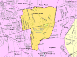 Location within the state of New York

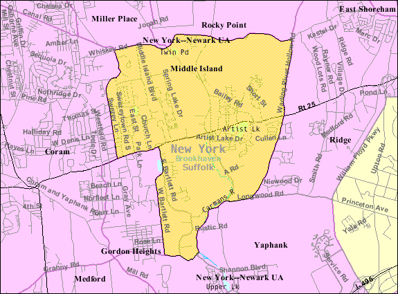
Coordinates: 40°53′6″N 72°56′36″W / 40.885°N 72.94333°WCoordinates: 40°53′6″N 72°56′36″W / 40.885°N 72.94333°W Country United States State New York County Suffolk Area – Total 8.3 sq mi (21.5 km2) – Land 8.3 sq mi (21.4 km2) – Water 0.1 sq mi (0.2 km2) Elevation 82 ft (25 m) Population (2000) – Total 9,702 – Density 1,175.9/sq mi (454.0/km2) Time zone Eastern (EST) (UTC-5) – Summer (DST) EDT (UTC-4) ZIP code 11953 Area code(s) 631 FIPS code 36-46976 GNIS feature ID 0957111 Middle Island is a hamlet (and census-designated place) in Suffolk County, New York, United States. The population was 9,702 at the 2000 census. It is situated between the towns of Coram and Ridge, to the west and east, respectively, and Rocky Point and Yaphank to the north and south. The name derives from the fact that it lies approximately half way between the Eastern and Western ends of Long Island (East River and Montauk Point) as well as half way between the Northern and Southern boundaries (Long Island Sound and the Atlantic Ocean).
Middle Island is a community in the Town of Brookhaven served by the Longwood Central School District Longwood School District (58 square miles) is the biggest school district on Long Island. The Longwood Public Library is located in Middle Island.
Parks within Middle Island include Cathedral Pines County Park (formerly a Boy Scout Camp) and the adjacent Prosser Pines County Park. Middle Island is surrounded by three public golf courses. Middle Island Country Club and Spring Lake Golf Club are both within Middle Island; Mill Pond Golf Course is just to the South, in Yaphank.
Contents
Geography
Middle Island is located at 40°53′6″N 72°56′36″W / 40.885°N 72.94333°W (40.885095, -72.943452)[1].
According to the United States Census Bureau, the CDP has a total area of 8.3 square miles (21 km2), of which, 8.2 square miles (21 km2) of it is land and 0.1 square miles (0.26 km2) of it (0.84%) is water. Middle Island has many lakes such as Spring Lake, Artist Lake, and Pine Lake (which has a new dock). Middle Island also contains the headwaters of the Carmans River, which originally began north of NY 25 and Old Middle Island Road, but now begins within Cathedral Pines County Park.
History
The history of Middle Island goes back at least to 1766, when the first Presbyterian church was built. Rev. David Rose, who was also a doctor and pastor of the South Haven church as well, covered his immense parish on horseback, with saddle bags filled with Bibles and medicines. A cemetery was opened just across from the church, in 1766.
The first schoolhouse was built in 1813, just east of the church. In 1837, a new church was built just to the rear of the older one, and served the community for 200 years until the new Christian Education building was built at the Longwood Estate in 1966.
For over 100 years (until it was burned down in 1971), Pfeiffer's Store was a center of activity for Middle Island and surrounding communities. A nearby lake, known as Corwin's Pond, was renamed "Artist Lake" after Alonzo Chappel settled there in 1869.
 Plaque commemorating spot where Ralph Johnstone's plane landed after setting altitude record of 8,471 feet on October 27, 1910 at Artist Lake on NY 25.
Demographics
As of the 2000 census[2], there were 9,702 people, 3,720 households, and 2,548 families residing in the CDP. The population density was 1,175.9 per square mile (454.1/km²). There were 3,900 housing units at an average density of 472.7/sq mi (182.5/km²). The racial makeup of the CDP was 85.45% White, 7.58% African American, 0.25% Native American, 2.44% Asian, 0.06% Pacific Islander, 1.92% from other races, and 2.31% from two or more races. Hispanic or Latino of any race were 6.87% of the population.
Of the 3,720 households, 31.2% had children under the age of 18 living with them, 51.0% were married couples living together, 13.2% had a female householder with no husband present, and 31.5% were non-families. 23.7% of all households were made up of individuals and 6.9% had someone living alone who was 65 years of age or older. The average household size was 2.53 and the average family size was 3.01.
In the CDP the population was spread out with 22.5% under the age of 18, 8.2% from 18 to 24, 32.6% from 25 to 44, 22.9% from 45 to 64, and 13.7% who were 65 years of age or older. The median age was 37 years. For every 100 females there were 90.6 males. For every 100 females age 18 and over, there were 86.9 males.
The median income for a household in the CDP was $50,818, and the median income for a family was $58,171. Males had a median income of $41,618 versus $30,516 for females. The per capita income for the CDP was $23,129. About 4.3% of families and 6.3% of the population were below the poverty line, including 7.9% of those under age 18 and 6.6% of those age 65 or over.
References
- ^ "US Gazetteer files: 2010, 2000, and 1990". United States Census Bureau. 2011-02-12. http://www.census.gov/geo/www/gazetteer/gazette.html. Retrieved 2011-04-23.
- ^ "American FactFinder". United States Census Bureau. http://factfinder.census.gov. Retrieved 2008-01-31.
External links
Town of Brookhaven, New York County Villages Belle Terre · Bellport · Lake Grove · Mastic Beach · Old Field · Patchogue · Poquott · Port Jefferson · ShorehamHamlets Blue Point · Brookhaven · Calverton · Canaan Lake · Center Moriches · Centereach · Cherry Grove · Coram · Crystal Brook · Cupsogue Beach · Davis Park · East Moriches · East Patchogue · East Setauket · East Shoreham · Eastport · Farmingville · Fire Island Pines · Gordon Heights · Hagerman · Holbrook · Holtsville · Lake Ronkonkoma · Manorville · Mastic · Medford · Middle Island · Miller Place · Moriches · Mount Sinai · North Bellport · North Patchogue · Ocean Bay Park · Point O' Woods · Port Jefferson Station · Ridge · Rocky Point · Ronkonkoma · Selden · Setauket · Shirley · Sound Beach · South Haven · Stony Brook · Strongs Neck · Terryville · Upton · Wading River · Water Island · West Manor · YaphankIndian
reservationPoospatuckWebsite: brookhaven.orgCategories:- Brookhaven, New York
- Hamlets in New York
- Census-designated places in New York
- Populated places in Suffolk County, New York


Wikimedia Foundation. 2010.