- Ridge, New York
Infobox Settlement
official_name = Ridge, New York
settlement_type = CDP
nickname =
motto =
imagesize =
image_caption =
image_pushpin_
pushpin_label_position =
pushpin_map_caption =Location within the state of New York
pushpin_mapsize =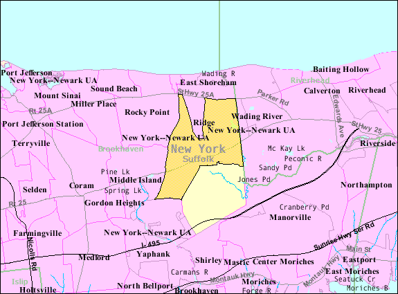
mapsize = 250px
map_caption = U.S. Census Map
mapsize1 =
map_caption1 =subdivision_type = Country
subdivision_name =United States
subdivision_type1 = State
subdivision_name1 =New York
subdivision_type2 = County
subdivision_name2 = Suffolk
government_footnotes =
government_type =
leader_title =
leader_name =
leader_title1 =
leader_name1 =
established_title =
established_date =area_footnotes =
area_magnitude =
area_total_km2 = 35.1
area_land_km2 = 34.9
area_water_km2 = 0.2
area_total_sq_mi = 13.6
area_land_sq_mi = 13.5
area_water_sq_mi = 0.1population_as_of = 2000
population_footnotes =
population_total = 13380
population_density_km2 = 383.6
population_density_sq_mi = 993.6timezone = Eastern (EST)
utc_offset = -5
timezone_DST = EDT
utc_offset_DST = -4
elevation_footnotes =
elevation_m = 28
elevation_ft = 92
latd = 40 |latm = 54 |lats = 26 |latNS = N
longd = 72 |longm = 52 |longs = 58 |longEW = Wpostal_code_type =
ZIP code
postal_code = 11961
area_code = 631
blank_name = FIPS code
blank_info = 36-61665
blank1_name = GNIS feature ID
blank1_info = 0962492
website =
footnotes =Ridge is a
census-designated place (CDP) inSuffolk County, New York ,United States . The population was 13,380 at the 2000 census.Ridge is served by the
Longwood Central School District .Geography
Ridge is located at coor dms|40|54|26|N|72|52|58|W|city (40.907128, -72.882909)GR|1.
According to the
United States Census Bureau , the CDP has a total area of 13.6square mile s (35.1km² ), of which, 13.5 square miles (34.9 km²) of it is land and 0.1 square miles (0.2 km²) of it (0.66%) is water.Ridge is located at the northwestern end of the Long Island Pine Barrens Region and is referred to by a sign in the center of town as the "Gateway to the Pine Barrens."
History
The Longwood Estate
In 1693,
William "Tangier" Smith , who owned a homestead in Setauket, New York, was allowed to purchase a large tract of land on the South Shore of Long Island in recognition of his beingmayor ofTangier in Africa. The land, calledSt. George's Manor , stretched from theCarmans River (then called the Connecticut River) in the west to the edge of Southampton Town in the east with a northern border around present-dayNew York State Route 25 , as much as 81,000 acres (328 km²) of land. He made his manor seat on the south shore in present-day Mastic, and the northern part, now the south side of Ridge, was called "The Swamp" or "Longswamp." A house wasn't built at Longswamp until after theAmerican Revolution . In 1817,William Sydney Smith inhabited the house and changed the name to "Longwood".In 1955, what then remained of William Smith's original manor was primarily located in Ridge and was surrounded by the world growing up around it, in the form of the
Brookhaven National Laboratory and the surrounding towns becoming increasingly populated. Longwood's 750 acres (3.04 km²) fell into the hands of Elbert Clayton Smith, who immediately moved his family from California to live there. He seems to have been very generous to his new community; his donations included 51 acres (0.21 km²) to the school board for the construction of Longwood High School and six acres (0.02 km²) to Middle Island Presbyterian Church. In 1967, Elbert Smith died, and the Longwood Estate was carved into housing developments and nearly destroyed until enough noise was made about preservation to have the house and 35 acres (0.14 km²) of land given to the Town of Brookhaven in 1974."Randallville"
In 1738, northern Ridge was settled by widower Samuel Randall of
North Stonington, CT ; his only sonStephen Randall and his descendants farmed a 4,000 acre (16 km²) farm on a plot of ground that Samuel had always referred to as "the Ridge" based on the geographical terrain. First called "Randallville", Ridge was the name selected by its residents for postal delivery and remains the name for this hamlet to this day. The Randall burial plot near the William Floyd Parkway includes the grave of Lt. Stephen Randall, patriot of the American Revolution and a Suffolk CountyMilitia veteran of theBattle of Long Island ,August 26 ,1776 .Demographics
As of the
census GR|2 of 2000, there were 13,380 people, 5,545 households, and 3,476 families residing in the CDP. Thepopulation density was 993.6 per square mile (383.5/km²). There were 5,922 housing units at an average density of 439.8/sq mi (169.7/km²). The racial makeup of the CDP was 92.99% White, 3.45% African American, 0.28% Native American, 0.90% Asian, 0.03% Pacific Islander, 0.75% from other races, and 1.59% from two or more races. Hispanic or Latino of any race were 3.51% of the population.There were 5,545 households out of which 27.4% had children under the age of 18 living with them, 52.9% were married couples living together, 7.5% had a female householder with no husband present, and 37.3% were non-families. 34.4% of all households were made up of individuals and 28.5% had someone living alone who was 65 years of age or older. The average household size was 2.38 and the average family size was 3.09.
In the CDP the population was spread out with 23.2% under the age of 18, 5.4% from 18 to 24, 24.5% from 25 to 44, 17.8% from 45 to 64, and 29.1% who were 65 years of age or older. The median age was 43 years. For every 100 females there were 82.9 males. For every 100 females age 18 and over, there were 76.9 males.
The median income for a household in the CDP was $44,140, and the median income for a family was $60,039. Males had a median income of $49,539 versus $31,384 for females. The
per capita income for the CDP was $23,387. About 4.4% of families and 6.5% of the population were below thepoverty line , including 7.5% of those under age 18 and 6.0% of those age 65 or over.References
* [http://www.longwood.k12.ny.us/history/ridge/sestate.htm Lauer, Jean C. "The Longwood Estate." 1980.]
*Lanyon, Genevieve Randall and Wells, Hazel Randall "A Randall Family of Long Island, NY" 1989.External links
* Longwood's Journey (Longwood Public Library):
** [http://www.longwood.k12.ny.us/history/ridge.htm Ridge general history]
** [http://www.longwood.k12.ny.us/history/ridge/icy%20hollow.htm "The Elusive Legend of Icy Hollow", by Phil Mintz (Originally published in "Newsday")]
** [http://www.longwood.k12.ny.us/history/ridge/panamoka.htm Lake Panamoka history]

Wikimedia Foundation. 2010.