- Fire Island, New York
Infobox Settlement
official_name = Fire Island, New York
settlement_type = CDP
nickname =
motto =
imagesize =
image_caption =
image_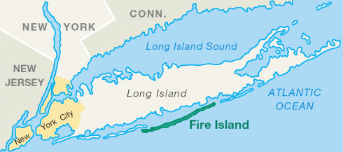
mapsize = 250x200px
map_caption = Fire Island
mapsize1 =
map_caption1 =subdivision_type = Country
subdivision_name =United States
subdivision_type1 = State
subdivision_name1 =New York
subdivision_type2 = County
subdivision_name2 = Suffolk
government_footnotes =
government_type =
leader_title =
leader_name =
leader_title1 =
leader_name1 =
established_title =
established_date =area_footnotes =
area_magnitude =
area_total_km2 = 22.64
area_land_km2 = 22.5
area_water_km2 = 0.1415
area_total_sq_mi = 8.742
area_land_sq_mi = 8.687
area_water_sq_mi = 0.05464population_as_of = 2000
population_footnotes =
population_total = 491Fact|date=July 2008
population_density_km2 = 21.82
population_density_sq_mi = 56.52timezone = Eastern (EST)
utc_offset = -5
timezone_DST = EDT
utc_offset_DST = -4
elevation_footnotes =
elevation_m = 1
elevation_ft = 3
latd = 40 |latm = 39 |lats = 11 |latNS = N
longd = 73 |longm = 7 |longs = 33 |longEW = Wpostal_code_type =
ZIP code
postal_code = 11770, 11706
area_code = 631
blank_name = FIPS code
blank_info = 36-25839
blank1_name = GNIS feature ID
blank1_info = 1852899
website =
footnotes =Fire Island is a
barrier island , approximately 31 miles (50 km) long and varying between approximately 0.1 mile (160 m) to 0.25 mile (400 m) wide. Fire Island passes through southernSuffolk County, New York , and is southeast ofLong Island separated from the main land by theGreat South Bay in theU.S. state ofNew York , running approximately SW to NE. The land area is 22.5 km² (8.687 sq mi) and a permanent population of 491 people was reported as of the 2000 census. (There are hundreds of thousands of summertime residents, groupers and daytrippers.) The island is composed of three communities, as defined by the Census Bureau. The largest of these is Fire Island (CDP), which is unincorporated and stretches through the southern portion of the towns of Babylon, Islip and Brookhaven, and has a 2000 census population of 310 inhabitants. There are also two villages in the Islip section of the island, Saltaire (pop. 43) and Ocean Beach (pop. 138). In addition, a part of Fire Island CDP is not even on the island, but on a separate island adjacent to West Hampton Dunes. The stated land area and population figures result when this section is subtracted out. [http://factfinder.census.gov/servlet/DTTable?_bm=y&-show_geoid=Y&-tree_id=4001&-_caller=geoselect&-context=dt&-errMsg=&-all_geo_types=Y&-mt_name=DEC_2000_SF1_U_P001&-redoLog=true&-transpose=N&-search_map_config=|b=50|l=en|t=4001|zf=0.0|ms=sel_00dec|dw=0.008884371962461743|dh=0.0050482751198916735|dt=gov.census.aff.domain.map.EnglishMapExtent|if=gif|cx=-72.74395621258952|cy=40.76803099960887|zl=1|pz=1|bo=318:317:316:314:313:323:319|bl=362:393:358:357:356:355:354|ft=350:349:335:389:388:332:331|fl=403:381:204:380:369:379:368|g=01000US&-PANEL_ID=p_dt_geo_map&-_lang=en&-geo_id=07000US361030400025839&-geo_id=07000US361031000025839&-geo_id=07000US361033800025839&-geo_id=07000US361033800054430&-geo_id=07000US361033800064881&-geo_id=101$10000US361031595076000&-geo_id=101$10000US361031595076001&-CONTEXT=dt&-format=&-search_results=01000US&-CHECK_SEARCH_RESULTS=N&-ds_name=DEC_2000_SF1_U]Geography
Fire Island is about 5 1/2 miles (8.9 km) south of the main land of Long Island (although within a mile in its eastern portion). It is separated from the main land by a series of interconnected bays -- (
Great South Bay ,Patchogue Bay ,Bellport Bay ,Narrow Bay andMoriches Bay ). The island is accessible by automobile from Long Island by theRobert Moses Causeway on its western end to the Parking Fields for day use and by William Floyd Parkway (Suffolk County Road 46) near its eastern end. Motorized vehicles (except for emergency access reasons) do not travel between the two ends. Though essentially the island and its resort towns are accessible by the numerous ferries there are few service oriented vehicles and police and fire fighting buggies.Fire Island is located at 40° 39' 35" North, 73° 5' 23" West (40.653188, -73.125795).GR|1 According to the
United States Census Bureau , Fire Island has a total area of 22.64km² (8.742 mi²), which includes 0.1415 km² of water.History
Physical history
The physical attributes of the island have changed over time and it continues to change. At one point it stretched more than 60 miles from
Jones Beach Island toSouthampton (village), New York .Around 1683
Fire Island Inlet broke through separating it from Jones Beach Island.Thompson, B. F. (1839). History of Long Island; containing an account of the discovery and settlement; with other important and interesting matters to the present time. New York, E. French.]The Fire Island Inlet was to grow to nine miles in width before receding. The
Fire Island Light house built in 1858 was built right on the inlet but Fire Island's western terminus at Democrat Point has steadily moved west so that the lighthouse today is six miles from the inlet.Fire Island separated from Southampton in a 1931
Nor'easter whenMoriches Inlet broke through. Moriches Inlet and efforts by local communities east of Fire Island to protect their beach front with jetties have led to an interruption in thelongshore drift of sand going from east to west and is blamed for erosion of the Fire Island beachfront. Between these major breaks there have been reports over the years of at least sixinlet s that broke through the island but have since disappeared.Origin of name
The origin of Fire Island's name is not certain. It is believed its Native American name was Sictem Hackey which translated to "Land of the Secatogues". The
Secatogue s were a tribe in theBay Shore, New York , area. It was part of what was also called the "Seal Islands."Historian Richard Bayles suggested that the name Fire derives from a misinterpretation or corruption of the Dutch word "vijf" (for five) or in another version "vier" (or four) referring to the number of islands near the Fire Island inlet. [ [http://www.fairharbor.com/history_fi_first_contact.htm Fairharbor.com history - Retrieved November 2, 2007] ]
At times histories have referred to it in the plural Fire Islands because of the inlet breaks.
Other versions say the island derived its name from fires built on the sea's edge by Native Americans or by pirates to lure unsuspecting ships into the sandbars. Some say it is how portions of the island look to be on fire from sea in the Autumn. Yet another version says it comes from the rash caused by
poison ivy on the island.The name of Fire Island first appeared on a deed in 1789. [http://www.nps.gov/fiis/historyculture/fireislandorigin.htm National Park Service history] . Retrieved November 2, 2007.]
While the western portion of the island was referred to as Fire Island for many years the eastern portion was referred to as Great South Beach until 1920 when widespread development of the island caused the whole island to be referred to as Fire Island.
ettlement
William "Tangier" Smith held title to the entire island in the 1600s, under a royal patent fromThomas Dongan . The remnants of Smith'sManor of St. George are open to the public inShirley, New York .The first large house was built in 1795 in Cherry Grove by Jeremiah Smith. Smith was said to have lured ships to their doom and killed the crews. [ [http://www.newsday.com/community/guide/lihistory/ny-historytown-hist0071,0,3443983.story?coll=ny-lihistory-navigation Fire Island: From Pirates to Slavery to Fun in the Sun - Newsday - Retrieved November 3, 2007] ] [Stansell, Christine. "The New Republic." March 26, 2008. From an article on the life of
Margaret Fuller , who died 1850 in a shipwreck at Fire Island: "The Fire Islanders of the day were a nasty group, who lived off pickings from shipwrecks that washed up on the beach, and they had no use for rescue efforts. So although the boat was in clear sight of the shore, no one acted while there was time. The family spent the night with other desperate passengers huddled on the disintegrating ship."]In the early 1800s when
slavery was still legal in New York, slave runners built stockades on the island by the Fire Island Inlet.The first Fire Island Lighthouse was built in 1825 and was replaced by the current lighthouse in 1858.
In 1855 David S.S. Sammis bought 120 acres near the Fire Island Lighthouse and built the Surf Hotel at what today is Kismet. Sammis operated the hotel until 1892 when the state took it over. In 1908 it became the first state park on Long Island.
In 1868 Archer and Elizabeth Perkinson bought the land around Cherry Grove and Fire Island Pines. They built a hotel in 1880.
In 1887 the Coast Guard established 11 manned life saving stations on the island.
In 1892 troops were called out to suppress a potential riot at Democrat Point over a [http://www.newsday.com/community/guide/lihistory/ny-past711,0,5538679.story?coll=ny-lihistory- cholera panic] .
In 1908 Ocean Beach was established followed by Saltaire in 1910.
In 1921 the Perkinsons sold the land around Cherry Grove in small lots. Bungalows from the newly closed
Camp Upton inYaphank, New York were ferried over the Great South Bay to build the new community. Duffy's Hotel was built in 1930.The
Great Hurricane of 1938 devastated much of the island and made it appear undesirable to many. However, Duffy's Hotel remained relatively undamaged. According to legend, the gay population began to concentrate in Cherry Grove at Duffy's Hotel withChristopher Isherwood andW. H. Auden dressed asDionysus and Ganymede and carried aloft on a gilded litter by a group of singing followers. [Cherry Grove Fire Isla by Esther Newton – 1995 - Beacon Press ISBN 0807079278] The gay influence was continued in the 1960s when male modelJohn B. Whyte developed Fire Island Pines. The Pines currently has some of the most expensive property on the island and accounts for two-thirds of the island's swimming pools. [ [http://www.fireislandcc.org/fipines.html Fire Island Pines Chamber of Commerce - Retrieved October 31, 2007] ]In 1954
Robert Moses built theCaptree Causeway to the western end of the island. Opponents, fearing that this was the beginning of plans for the continuation ofOcean Parkway (Long Island) which would have run down the middle of the island, organized and eventually stopped the Parkway.In September 1964
Lyndon Johnson signed the bill creating Fire Island National Seashore.Landmarks and preserves
Except for the western 4 1/2 miles (7.5 km) of the island, the island is protected as part of
Fire Island National Seashore . Robert Moses State Park, occupying the remaining western portion of the island, is one of the popular recreational destinations in theNew York City area. TheFire Island Light stands just east of Robert Moses State Park.A memorial to TWA800 is located on the eastern end at
Smith Point County Park near where it crashed.Inhabitants
The incorporated villages of Ocean Beach and Saltaire within Fire Island National Seashore are carfree during the summer tourist season (
Memorial Day throughLabor Day ) and permit only pedestrian and bicycle traffic (during certain hours only in Ocean Beach). For off-season use, there are a limited number of driving permits for year-round residents and contractors. The hamlet of Davis Park allows no vehicles or bicycles year round. Fire Island also contains a number of unincorporated villages (hamlets). Two of these hamlets, known as the Fire Island Pines and Cherry Grove, have a reputation as being popular destinations forLGBT vacationers.Beach erosion largely due to construction of jetties at the Moriches Inlet, opened naturally by a storm in 1931 and widened by the Labor Day
Hurricane of 1938 , is described in a report on the [http://www2.sunysuffolk.edu/mandias/38hurricane/geological_impact.html geological effects of the Hurricane of 1938] .The avant-garde American poet
Frank O'Hara was struck and injured by a beach buggy on the early morning ofJuly 24 ,1966 , and died the following day.Demographics
As of the
census GR|2 of 2000, there were 491 people, 138 households, and 77 families residing on Fire Island (which includes many other communities besides Cherry Grove). Thepopulation density was 21.82/km² (52.82/mi²). There were 4,153 housing units at an average density of 184.6/km² (478.1/mi²). The racial makeup of the town was 96.77% White, 0.65% Asian, 0.32% Pacific Islander, 0.65% from other races, and 1.61% from two or more races. Hispanic or Latino of any race were 2.90% of the population.There were 138 households on Fire Island out of which 25.4% had children under the age of 18 living with them, 48.6% were married couples living together, 2.2% had a female householder with no husband present, and 44.2% were non-families. 34.8% of all households were made up of individuals and 10.1% had someone living alone who was 65 years of age or older. The average household size was 2.20 and the average family size was 2.90.
Fire Island's population was spread out with 20.6% under the age of 18, 6.5% from 18 to 24, 29.0% from 25 to 44, 33.5% from 45 to 64, and 10.3% who were 65 years of age or older. The median age was 42 years. For every 100 females there were 133.1 males. For every 100 females age 18 and over, there were 143.6 males.
In popular culture
The song "Come to Me" has been described as "the definitive Fire Island dance classic" because of the legendary beach concert performance by the 16-year-old
France Joli before an oceanfront Fire Island audience of 5000 onJuly 7 ,1979 . WhenDonna Summer was a last-minute cancellation, Joli stepped in as a replacement and became an overnight sensation, with her "Come to Me" single climbing into "Billboard "'s Top 20 during the following months. [ [http://www.francejoli.net/dma/interview/ Ferguson, Dean. "France Joli: Full Circle," "DMA/Dance Music Authority", Volume 4, Number 11, December 1996.] ]"When Ocean Meets Sky" [ [http://www.craytonrobeyproductions.com/ "When Ocean Meets Sky"] ] (2003), a documentary detailing the 50-year history of the Fire Island Pines community, had its television premiere on
June 10 ,2006 . The film includes much previously unseen archival footage, but unfortunately the famed 1979 performance of vocalist France Joli is presented only in still photographs with music background, suggesting no footage of that well-remembered event exists. The film does include interviews with several who still regard Joli's performance in awe.Frank Perry's "Last Summer " (1969), adapted by Eleanor Perry from Evan Hunter's novel about a summer of sexual discovery on Fire Island, brought an Oscar nomination for actressCatherine Burns . "Garbo Talks " (1984) has scenes of the Fire Island ferry. "Longtime Companion " (1990) is a drama that recreates chronologically the spread ofAIDS during the 1980s. "Returning Mickey Stern " (2003) was shot almost entirely in Seaview and Ocean Beach; the entire cast and crew were housed on Fire Island.The Post Office scene in
Men in Black II was shot outside the Fire Island Lighthouse. The mockumentary "Beach Comber" [ [http://video.google.com/videoplay?docid=-9087919924829576282&q=beach+comber "Beach Comber"] ] was filmed on Fire Island in 2004. ABC's reality show "One Ocean View " (2006) was shot on Fire Island. Fire Island is also the setting ofTerrence McNally 's play "Lips Together, Teeth Apart ".The 1977
Judas Priest song "Raw Deal" has the line, "A couple cards played rough stuff, New York, Fire Island".Tanya Donelly 's 1997 song "Pretty Deep" has the line, "Remember when we all went out to Fire Island / You thought you saw a body on the beach / When we got closer it was just a tire". The song "Gay Messiah" on the 2004 albumWant Two byRufus Wainwright makes a reference to the popularity of Fire Island for gay and lesbian tourists, remarking that when the "gay messiah" comes "He will fall from the star / ofStudio 54 / and appear on the sand / of Fire Island's shore". The 2003 albumWelcome Interstate Managers byFountains of Wayne featured the song "Fire Island" about two siblings' home-alone shenanigans while their parents vacation on the island.The
Village People included a song titled "Fire Island" on their 1977 debut album, "Village People". In the song, they refer to the island as "a funky weekend" and mention several locations on the island such as the Ice Palace, the Monster, the Blue Whale and the Sandpiper. The song also includes the warning "Don't go in the bushes" because "someone might grab ya" or "someone might stab ya."In the 2008 movie,
The Wackness , the Squires family have a beach house on Fire Island that is used in at least two scenes.Fire Island is featured prominently in
Ann Brashares 's 2008 novel "The Last Summer (of You and Me) ", about two sisters and a friend who grow up together, vacationing on the island every summer.Fire Island is repeatedly referenced on the NBC sitcom Will and Grace. Many references are made to the adventures had by Will Truman and Jack McFarland during their vacations on Fire Island. The impression given in the references is that gay people are welcome and there is a loosening on one's inhibitions when there.
Locations
Following are the locations on the island from west to east [ [http://www.nps.gov/fiis/planyourvisit/upload/FIIS_Map2_5-2006.pdf Official NPS Map - Retrieved November 2, 2007] ]
*
Fire Island Inlet
*Robert Moses State Park (part)*Robert Moses State Park (part)
*Fire Island Light
*Kismet
*Seabay Beach
*Saltaire (village)
*Fair Harbor
*Dunewood
*Lonelyville
*Atlantique Beach
*Atlantique
*Robbins Rest
*Fire Island Summer Club
*Corneille Estates
*Ocean Beach (village)
*Seaview*Ocean Bay Park
*Point O'Woods
*Oakleyville
*Sunken Forest
*Cherry Grove
*Fire Island Pines
*Talisman/Barrett Beach
*Water Island
*Blue Point Beach
*Davis Park
*Watch Hill - National Park Service facility in the central part of the island, including a public marina, camp ground visitor center and nature trail.
*Otis Pike Wilderness
*Bellport Beach
*Smith Point County Park
*Moriches Inlet Other small islands around Fire Island
Following are associated islands in the Fire Island National Seashore Jurisdiction from west to east:
*Sexton Island – A small island across from the Fire Island Lighthouse with approximately 20 small, private, summer houses. There is no ferry service nor electrical service.
*West Fire Island – A small island with about a dozen houses. It has no telephone or electrical service.
*East Fire Island – Another longer and larger island next to West Fire Island, this island, unlike West Fire Island, is uninhabited. People are allowed, although there is no ferry service, so the only way to get there is on your own boat.
*Ridge Island
*Pelican Island
*John Boyle Island
*Hospital Island Other locations
*
Clam Pond – A small cove between Saltaire and Fair HarborFamous summer residents
After the Manhattan theater community began staying on Fire Island during the 1920s, the island had numerous summer celebrity residents.
*
Louis Alter , songwriter ("Do You Know What It Means to Miss New Orleans ")
*Anne Bancroft , actress
*Gary Beach , Tony award winning actor [ [http://www.playbill.com/news/article/96374.html "Playbill"] ]
*Ann Brashares , author of "The Last Summer (of You and Me)", set on Fire Island
*Mel Brooks , actor, writer, director
*Robert John Burke , "Robocop 3"
*Truman Capote , author
*Liz Claiborne, fashion designer
*Claudette Colbert , actress
*Paulette Cooper , author
*Mart Crowley , playwright
*Adam Curry , The Podfather
*Mark Doty , poet, non-fiction writer
*David Duchovny , actor
*Peggy Fears , Broadway performer
*Tina Fey , comedy writer and actress, "30 Rock "
*Peter Greenberg , TV travel authority
*Rex Harrison , actor
*Ethan Hawke , actor, novelist
*Nat Hentoff , columnist, jazz critic
*France Joli , vocalist whose performance at age 16 during the July 1979 oceanfront party catapulted her career
*Harvey Keitel , actor
*Paul Krassner , author, editor
*Carson Kressley , TV fashion authority
*Will Leitch , author
*Harding Lemay , playwright and TV headwriter, who scripted "Another World" on Fire Island
*Albert Lepage, Lepage Bakeries in Auburn, Maine
*Mary Martin , Broadway performer
*Malachy McCourt , playwright/actor whose memoir "A Monk Swimming " includes his Fire Island visits
*Joe Namath , football player
*Kevin Nash , professional wrestler
*Pola Negri , silent film actress
*Frank O'Hara , poet, playwright
*Tony Randall , actor
*John C. Reilly , actor
*Carl Reiner , actor
*Tony Roberts , actor
*Ally Sheedy , actress
*Tedi Thurman , Miss Monitor
*Uma Thurman , actress
*Stanley Tucci , actor
*Herman Wouk , pulitzer prize novelist
*Jeffrey Zeldman , web guruSee also
*
Jones Beach Island References
External links
* [http://www.fireislandvision.com Fine art photos of Fire Island]
* [http://www.fireisland.com Fire Island News and Online Travel Guide]
* [http://query.nytimes.com/gst/fullpage.html?res=9A06E3D9153FF931A3575BC0A960958260&sec=travel&pagewanted=2 "Escapades on Fire Island" by Ralph Blumenthal ("New York Times", August 2, 1996)]
* [http://www.fireislandferries.com Fire Island Ferries]
* [http://www.fireislandlighthouse.com Fire Island Lighthouse]
*wikitravelpar|Fire_Island
Wikimedia Foundation. 2010.