- Barnum Island, New York
Infobox Settlement
official_name = Barnum Island, New York
settlement_type = CDP
nickname =
motto =
imagesize =
image_caption =
image_pushpin_
pushpin_label_position = none
pushpin_map_caption =Location within the state of New York
pushpin_mapsize =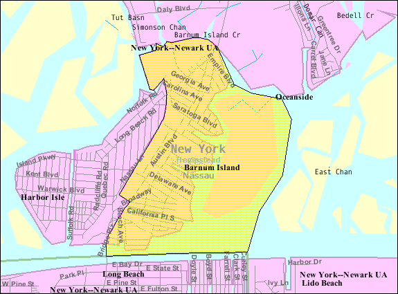
mapsize = 250px
map_caption = U.S. Census Map
mapsize1 =
map_caption1 =subdivision_type = Country
subdivision_name =United States
subdivision_type1 = State
subdivision_name1 =New York
subdivision_type2 = County
subdivision_name2 = Nassau
government_footnotes =
government_type =
leader_title =
leader_name =
leader_title1 =
leader_name1 =
established_title =
established_date =area_footnotes =
area_magnitude =
area_total_km2 = 3.4
area_land_km2 = 2.4
area_water_km2 = 1.0
area_total_sq_mi = 1.3
area_land_sq_mi = 0.9
area_water_sq_mi = 0.4population_as_of = 2000
population_footnotes =
population_total = 2487
population_density_km2 = 1016.1
population_density_sq_mi = 2631.8timezone = Eastern (EST)
utc_offset = -5
timezone_DST = EDT
utc_offset_DST = -4
elevation_footnotes =
elevation_m = 0
elevation_ft = 0
latd = 40 |latm = 36 |lats = 19 |latNS = N
longd = 73 |longm = 38 |longs = 51 |longEW = Wpostal_code_type =
ZIP code
postal_code = 11558
area_code = 516
blank_name = FIPS code
blank_info = 36-04550
blank1_name = GNIS feature ID
blank1_info = 1867393
website =
footnotes =Barnum Island is a hamlet (and
census-designated place ) in Nassau County,New York ,United States . The population was 2,487 at the 2000 census.Barnum Island is in the southwest part of the Town of Hempstead. It is separated from the Village of Island Park by the LIRR's track to Long Beach.
Geography
Barnum Island is located at coor dms|40|36|19|N|73|38|51|W|city (40.605203, -73.647403)GR|1.
According to the
United States Census Bureau , the CDP has a total area of 1.3square mile s (3.4km² ), of which, 0.9 square miles (2.4 km²) of it is land and 0.4 square miles (1.0 km²) of it (28.24%) is water.pecial Districts
Barnum Island has its own fire district, but is under contract with the Island Park Fire Department for emergency services. Barnum Island is included in the Island Park School District and ZIP code (11558).
Demographics
As of the
census GR|2 of 2000, there were 2,487 people, 836 households, and 671 families residing in the CDP. Thepopulation density was 2,631.8 per square mile (1,021.5/km²). There were 854 housing units at an average density of 903.7/sq mi (350.8/km²). The racial makeup of the CDP was 91.56% White, 0.36% African American, 0.12% Native American, 2.25% Asian, 0.04% Pacific Islander, 3.54% from other races, and 2.13% from two or more races. Hispanic or Latino of any race were 10.29% of the population.There were 836 households out of which 26.0% had children under the age of 18 living with them, 65.3% were married couples living together, 10.9% had a female householder with no husband present, and 19.7% were non-families. 17.0% of all households were made up of individuals and 6.2% had someone living alone who was 65 years of age or older. The average household size was 2.86 and the average family size was 3.16.
In the CDP the population was spread out with 18.0% under the age of 18, 7.2% from 18 to 24, 28.4% from 25 to 44, 32.6% from 45 to 64, and 13.8% who were 65 years of age or older. The median age was 42 years. For every 100 females there were 97.5 males. For every 100 females age 18 and over, there were 93.8 males.
The median income for a household in the CDP was $79,656, and the median income for a family was $82,742. Males had a median income of $56,563 versus $37,727 for females. The
per capita income for the CDP was $33,498. About 9.1% of families and 10.8% of the population were below thepoverty line , including 18.1% of those under age 18 and 12.4% of those age 65 or over.References
External links

Wikimedia Foundation. 2010.