- Mastic Beach, New York
-
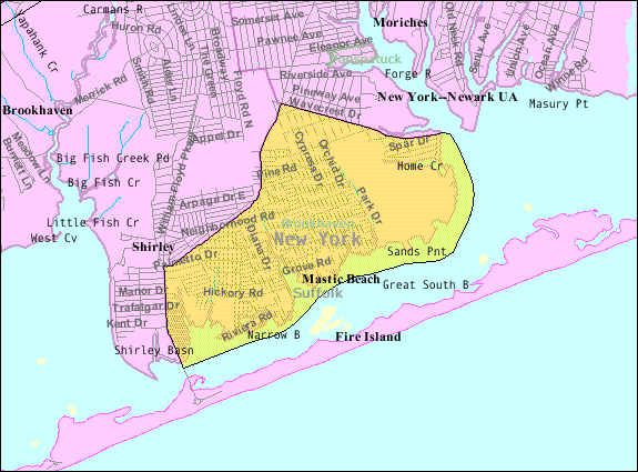
Mastic Beach — Village — Nickname(s): AntiHamptons Motto: Long Island's Best Kept Secret U.S. Census Bureau Map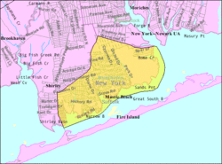 U.S. Census Bureau Map
 Mastic Beach
Coordinates: 40°45′41″N 72°50′47″W / 40.76139°N 72.84639°WCoordinates: 40°45′41″N 72°50′47″W / 40.76139°N 72.84639°W Country United States State New York County Suffolk Town Brookhaven Government - Type Village - Mayor Paul Breschard Area - Total 5.3 sq mi (13.8 km2) - Land 4.2 sq mi (11.0 km2) - Water 1.1 sq mi (2.8 km2) Elevation 7 ft (2 m) Population (2000) - Total 11,543 - Density 2,727.9/sq mi (1,053.2/km2) Time zone Eastern (EST) (UTC-5) - Summer (DST) EDT (UTC-4) ZIP code 11951 Area code(s) 631 FIPS code 36-46085 GNIS feature ID 0970340 Website http://www.masticbeachpropertyownersassociation.org Mastic Beach is a village in the southeast part of the Town of Brookhaven in Suffolk County, New York, United States. The population was 11,543 at the 2000 census.[1] The CDP is located in the general vicinity of the hamlet of Mastic Beach.
Mastic Beach is located on the South Shore of Long Island 70 miles (110 km) from New York City, and accessible via the Long Island Rail Road. Nearby are Smith Point County Park and the Fire Island National Seashore.
Mastic Beach is on a peninsula extending into Moriches Bay. Created in 1928, there are marinas, private docks, and several historic sites. There is sailing, swimming, fishing, birding, hiking, camping and shopping.
Mastic Beach is served by the William Floyd School District.
Contents
History
The hamlet of Mastic Beach was originally formed in 1928 by the private membership civic organization The Mastic Beach Property Owners Association (MBPOA). Over the years, the association has worked to make numerous improvements in Mastic Beach.
The mission of the MBPOA is to bring about a more neighborly feeling among its members, keep up the waterfront, and further the progress in obtaining a watchman, post office, electric current, better roads, garbage collection, and beaches. The objectives of the organization were "primarily the promulgation of acquaintance, good will, and protection of its interests and the interests of its members for the betterment of the property as a whole, with the view to inspiring individual improvement of various holdings." The MBPOA makes sure that property owners have a voice in their community when dealing with local government. Any property owner in Mastic Beach can join the MBPOA as long as it their intention is to create goodwill in Mastic Beach.
Mastic Beach became an incorporated village after a vote on Aug 31, 2010 where incorporation was approved by an almost 3 to 1 margin. The proposed incorporation needed to be passed by 51% in order for the hamlet to become a village. As of November 22nd, the Village is served by its first elected Trustees and Mayor Paul Breschard.
The Village of Mastic Beach village boundaries differ from those of the CDP. The village does not include the William Floyd House grounds as well as a few blocks in the extreme southwest of the CDP, but it adds several blocks west of Mastic Road and Commack Road.[2]
Geography
According to the United States Census Bureau, the CDP has a total area of 5.3 square miles (14 km2), of which, 4.2 square miles (11 km2) of it is land and 1.1 square miles (2.8 km2) of it (20.34%) is water.
Demographics
As of the census[1] of 2000, there were 11,543 people, 3,755 households, and 2,793 families residing in the CDP. The population density was 2,727.9 per square mile (1,053.6/km²). There were 4,375 housing units at an average density of 1,033.9/sq mi (399.3/km²). The racial makeup of the CDP was 88.16% White, 5.02% African American, 0.49% Native American, 0.91% Asian, 0.01% Pacific Islander, 2.64% from other races, and 2.77% from two or more races. Hispanic or Latino of any race were 10.59% of the population.
There were 3,755 households out of which 42.6% had children under the age of 18 living with them, 51.3% were married couples living together, 16.1% had a female householder with no husband present, and 25.6% were non-families. 18.4% of all households were made up of individuals and 6.3% had someone living alone who was 65 years of age or older. The average household size was 3.07 and the average family size was 3.49.
In the CDP the population was spread out with 31.8% under the age of 18, 8.5% from 18 to 24, 32.4% from 25 to 44, 19.7% from 45 to 64, and 7.5% who were 65 years of age or older. The median age was 32 years. For every 100 females there were 99.8 males. For every 100 females age 18 and over, there were 96.4 males.
The median income for a household in the CDP was $44,937, and the median income for a family was $49,219. Males had a median income of $37,871 versus $27,853 for females. The per capita income for the CDP was $17,046. About 9.2% of families and 11.3% of the population were below the poverty line, including 14.3% of those under age 18 and 8.1% of those age 65 or over.
References
- ^ a b "American FactFinder". United States Census Bureau. http://factfinder.census.gov. Retrieved 2008-01-31.
- ^ "Mastic Beach Village Exploratory Committee". Mastic Beach Village Exploratory Committee. http://masticbeach.org. Retrieved July 6, 2009.
External links
Town of Brookhaven, New York County Villages Belle Terre · Bellport · Lake Grove · Mastic Beach · Old Field · Patchogue · Poquott · Port Jefferson · ShorehamHamlets Blue Point · Brookhaven · Calverton · Canaan Lake · Center Moriches · Centereach · Cherry Grove · Coram · Crystal Brook · Cupsogue Beach · Davis Park · East Moriches · East Patchogue · East Setauket · East Shoreham · Eastport · Farmingville · Fire Island Pines · Gordon Heights · Hagerman · Holbrook · Holtsville · Lake Ronkonkoma · Manorville · Mastic · Medford · Middle Island · Miller Place · Moriches · Mount Sinai · North Bellport · North Patchogue · Ocean Bay Park · Point O' Woods · Port Jefferson Station · Ridge · Rocky Point · Ronkonkoma · Selden · Setauket · Shirley · Sound Beach · South Haven · Stony Brook · Strongs Neck · Terryville · Upton · Wading River · Water Island · West Manor · YaphankIndian
reservationPoospatuckWebsite: brookhaven.orgCategories:- Brookhaven, New York
- Villages in New York
- Census-designated places in New York
- Populated places in Suffolk County, New York

Wikimedia Foundation. 2010.