- Mattituck, New York
-
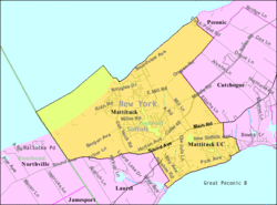
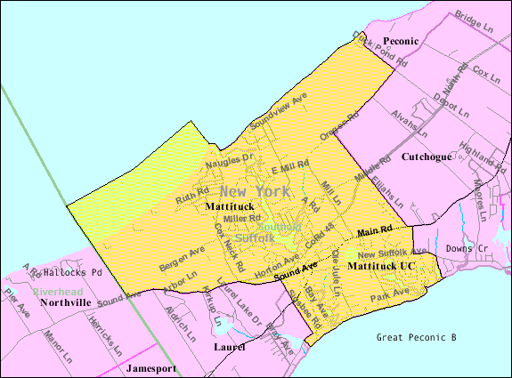
Mattituck — CDP — Mattituck Inlet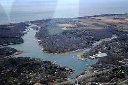

 Mattituck
Coordinates: 40°59′41″N 72°32′14″W / 40.99472°N 72.53722°WCoordinates: 40°59′41″N 72°32′14″W / 40.99472°N 72.53722°W Country United States State New York County Suffolk Town Southold Area – Total 10.2 sq mi (26.5 km2) – Land 8.6 sq mi (22.4 km2) – Water 1.6 sq mi (4.1 km2) Elevation 13 ft (4 m) Population (2000)[1] – Total 4,198 – Density 485.7/sq mi (187.5/km2) Time zone Eastern (EST) (UTC-5) – Summer (DST) EDT (UTC-4) ZIP code 11952 Area code(s) 631 FIPS code 36-46140 GNIS feature ID 0956678 Mattituck is a census-designated place in Suffolk County, New York, United States. The population was 4,198 at the 2000 census.[1]
Mattituck CDP roughly corresponds to the hamlet (unincorporated community) by the same name in the town of Southold.
Contents
History
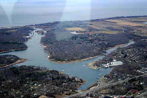
It is believed to have derived its name for the Native American name for the "Great Creek.".[2] The Mattituck Creek has been dredged and is used extensively by pleasure craft on Long Island Sound (the Mattituck Inlet is the entrance into Mattituck Creek and the whole waterway is now popularly referred to as Mattituck Inlet).
It is only one of two harbors (other being Mt. Sinai harbor) on the north side of Long Island on the Sound east of Port Jefferson, New York
The Mattituck Inlet and James Creek (which has also been dredged for boats) on the Peconic Bay come within 500 yards of each other and would provide a shortcut between the Peconic and Sound through the North Fork if connected via a canal. However authorities have resisted the connection fearing an ecological disaster. Still the inlet is blamed for coastal erosion because it interrupts the longshore drift on the sound.
The area was originally settled by English colonists. Corchaug Indians, who were the first residents of the area, sold land to Theophilus Eaton, governor of New Haven, CT. The meadowlands were held in common by the residents of Southold from its founding in 1640. The Township of Southold was established by Charter to the New Haven Colony of Connecticut in 1658. The woodlands were also held in common until 1661 when that land was divided among individual proprietors.
Mattituck hosts an annual Strawberry Festival and is located in the heart of over 30 vineyards in the Long Island Wine Region.
Geography
According to the United States Census Bureau, the community has a total area of 10.2 square miles (26.5 km²), of which, 8.6 square miles (22.4 km²) of it is land and 1.6 square miles (4.1 km²) of it (15.53%) is water.
Demographics
As of the census of 2000, there were 4,198 people, 1,651 households, and 1,231 families residing in the CDP. The population density was 485.7 per square mile (187.6/km²). There were 2,313 housing units at an average density of 267.6/sq mi (103.4/km²). The racial makeup of the hamlet was 96.62% White, 1.17% African American, 0.02% Native American, 0.52% Asian, 0.64% from other races, and 1.02% from two or more races. Hispanic or Latino of any race were 2.55% of the population.[1]
There were 1,651 households out of which 31.9% had children under the age of 18 living with them, 62.4% were married couples living together, 9.4% had a female householder with no husband present, and 25.4% were non-families. 21.8% of all households were made up of individuals and 12.2% had someone living alone who was 65 years of age or older. The average household size was 2.53 and the average family size was 2.97.[1]
In the community the population was spread out with 23.2% under the age of 18, 5.6% from 18 to 24, 25.0% from 25 to 44, 27.1% from 45 to 64, and 19.1% who were 65 years of age or older. The median age was 42 years. For every 100 females there were 92.9 males. For every 100 females age 18 and over, there were 88.9 males.[1]
The median income for a household in the hamlet was $55,353, and the median income for a family was $63,370. Males had a median income of $42,917 versus $34,813 for females. The per capita income for the CDP was $26,101. About 4.5% of families and 5.6% of the population were below the poverty line, including 5.7% of those under age 18 and 9.6% of those age 65 or over.[1]
Mattituck-Cutchogue Union Free School District is attended by residents of Mattituck, Cutchogue and Laurel.[citation needed] The sports team name is the Tuckers.[citation needed]
Notable residents
- James Aldrich, (1810–1866), born in Mattituck, noted poet and journalist[3]
See also
References
- ^ a b c d e f "American FactFinder". United States Census Bureau. http://factfinder.census.gov. Retrieved 2008-01-31.
- ^ Newsday Profile - Retrieved November 4, 2007
- ^ Who Was Who in America, Historical Volume, 1607-1896. Marquis Who's Who. 1967.
External links
Town of Southold, New York County Villages CDP Hamlets Cutchogue · East Marion · Fishers Island · Laurel · Mattituck · New Suffolk · Orient · Peconic · SoutholdWebsite: southold.northfork.netCategories:- Southold, New York
- Census-designated places in New York
- Hamlets in New York
- Populated places in Suffolk County, New York
- Place names in New York of Native American origin

Wikimedia Foundation. 2010.