- Grand Island, New York
Geobox Settlement
name = Grand Island
native_name =
other_name =
other_name1 =
category = Town
image_size = 100px
image_caption = Town Seal
flag_size =
symbol =
symbol_size =
nickname =
nickname1 =
motto =
country = United States
state = New York
region_type = County
region = Erie County
district_type =
district =
area_imperial = 33.3
area_land_imperial = 28.5
area_water_imperial = 4.8
area_water_percentage = auto
area_percentage_round = 2
area_round = 1
location =
lat_d = 43
lat_m = 00
lat_s = 43
lat_NS = N
long_d = 78
long_m = 57
long_s = 33
long_EW = W
elevation_imperial = 591
elevation_round = 1
population_as_of = 2000
population = 18621
population_density_imperial = 653.1
population_density_round = 1
established_type = Incorporated
established = 1852
leader = Peter McMahon "(2007)"
leader_type = Supervisor
timezone = EST
utc_offset = -5
timezone_DST = EDT
utc_offset_DST = -4
postal_code = 14072
postal_code_type = ZIP code
area_code = 716
area_code_type =
code2_type =
code2 =
free_type = FIPS code
free = 36-29828
free1_type = GNIS feature ID
free1 = 0979012
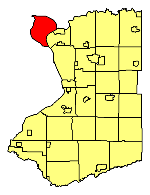
map_caption = Location of Grand Island in Erie County
map1 = New York Locator Map.png
map1_locator = New York
map2 = Map of USA NY.svg
map2_caption = Location of New York in the United States
website = http://www.grand-island.ny.us/Grand Island is a
town and anisland in Erie County,New York , USA. As of the 2000census , the town population was 18,621. The current town name derives from the French name "La Grande Ile," as Grand Island is the largest island in theNiagara River . The phrase "La Grande Ile" appears on the town seal.The Town of Grand Island is located at the northwestern corner of the county. The town is northwest of Buffalo,
New York . Interstate 190 andNew York State Route 324 cross the island.History
Period before the American Revolution
In the early historical period of the island, the 16th century, French explorers found the
Neutral Indian s living on the island. By 1651, the Senecas had destroyed this tribe and absorbed some of the survivors. The Seneca used the island for hunting and fishing.In 1764, as part of the Treaty of Cession after the
French and Indian War the island became part of the British colonies inNorth America .Period after the American Revolution
In 1815,
New York State purchased Grand Island and other small islands in theNiagara River from theIroquois nation for one thousand dollars in hand, and annually, forever, an annuity of $500 (to this day, paid every June). The treaty was signed by GovernorDaniel D. Tompkins ,Peter B. Porter , ChiefRed Jacket ,Falling Boards ,Twenty Canoes ,Sharp Shins ,Man Killer , and others. TheSenecas reserved the right to hunt, fish and fowl on the islands.In 1824, in a precursor to modern Zionism, journalist and Utopian
Mordecai Manuel Noah tried to found a Jewish homeland at Grand Island in the Niagara River, to be called "Ararat," afterMount Ararat , the Biblical resting place of Noah's Ark. MacArthur Award-winning cartoonistBen Katchor fictionalized Noah's scheme for Grand Island in his "The Jew of New York ".The Town of Grand Island was organized in 1852 from part of the Town of Tonawanda.
On August 25, 1993 the
Seneca Nation commenced an action to reclaim land that allegedly was taken from it without the approval of theUnited States in theUnited States District Court for the Western District of New York . TheSenecas argued that the 1815 transaction with New York State violated theTrade and Intercourse Act of 1790 , which states that no Native American lands are to be sold without consent of the Federal government. TheSenecas sought the ejection of more than 2,000 property owners on the Island. By decision and order dated June 21, 2002, the trial court held that the subject lands were ceded toGreat Britain in the 1764 treaties of peace and that the subject lands were not owned by the Seneca at the time of the1794 Treaty of Canandaigua and thatNew York State 's "purchase" of them in 1815 was intended to avoid conflict with theSenecas over land it already owned. This decision was appealed and theUnited States Court of Appeals for the Second Circuit affirmed the trial court's decision on September 9, 2004 TheSenecas then sought review of this decision by theSupreme Court of the United States which was denied on June 5, 2006.Geography
), of which, 28.5 square miles (73.8 km²) of it is land and 4.8 square miles (12.4 km²) of it (14.35%) is water.
The town is located entirely on the island of Grand Island in the
Niagara River . The river splits into two parts at the south end of the island and rejoins at the northwest end, before flowing west to theNiagara Falls .The town lies adjacent to the international border between
Ontario inCanada and theUnited States (although there is no directbridge orferry connection from the island to Canada). Paired bridges connect the south end of the island to the Town of Tonawanda, and another pair of bridges connects the northern end to the City of Niagara Falls in Niagara County. The two sets of bridges are connected by Interstate 190, a branch of theNew York State Thruway (Interstate 90 ). In addition,New York State Route 324 (Grand Island Boulevard) is conjoined with I-190 at the southern bridges and reaches its western terminus in the northern part of Grand Island.Adjacent Cities & Towns
*Niagara Falls,
Ontario - west
*Town of Tonawanda - southeast
*Niagara County, City of North Tonawanda - east
*Niagara County, Town of Wheatfield - northeast
*Niagara County, Town of Niagara - north
*Niagara County, City of Niagara Falls - northwestMajor Highways in the Town of Grand Island
*), passes through the center of the island by the way of the North and South Grand Island Bridges.
* (Grand Island Blvd.), East-West Highway from its northern terminus at I-190 south through the central part of town, joining I-190 as the route travels east (south) out of the town to the Town of Tonawanda.*
Beaver Island Parkway , North-South Parkway from I-190 toBeaver Island State Park . (NYS Reference Route 957B)*West River Parkway, North-South Parkway along the western edge of town that parallels the
Niagara River . It runs from Beaver Island Parkway in the south, north to East-West Park Rd. inBuckhorn Island State Park near I-190 and NY 324's northern terminus. (NYS Reference Route 957C)Demographics
As of the
census GR|2 of 2000, there were 18,621 people, 6,898 households, and 5,221 families residing in the town. Thepopulation density was 653.1 people per square mile (252.2/km²). There were 7,355 housing units at an average density of 257.9/sq mi (99.6/km²). The racial makeup of the town was 95.80% White, 3.165% African American, 0.25% Native American, 1.17% Asian, 0.01% Pacific Islander, 0.25% from other races, and 0.88% from two or more races. Hispanic or Latino of any race were 1.09% of the population.There were 6,898 households out of which 35.8% had children under the age of 18 living with them, 64.8% were married couples living together, 7.7% had a female householder with no husband present, and 24.3% were non-families. 20.2% of all households were made up of individuals and 7.9% had someone living alone who was 65 years of age or older. The average household size was 2.68 and the average family size was 3.13.
In the town the population was spread out with 26.7% under the age of 18, 6.5% from 18 to 24, 27.7% from 25 to 44, 27.7% from 45 to 64, and 11.3% who were 65 years of age or older. The median age was 39 years. For every 100 females there were 97.4 males. For every 100 females age 18 and over, there were 94.4 males.
The median income for a household in the town was $60,432, and the median income for a family was $70,521. Males had a median income of $48,457 versus $30,157 for females. The
per capita income for the town was $25,816. About 2.4% of families and 3.0% of the population were below thepoverty line , including 3.3% of those under age 18 and 5.1% of those age 65 or over.Communities and locations on Grand Island
*Falconwood – A hamlet on the southeast shore of the town.
*Ferry Village – A hamlet on the border of Beaver Island State Park.
*Hennepin Road – Road within Grandyle Village named after a French explorer,Louis Hennepin , who observed and describedNiagara Falls in 1677.
*Oakfield – A location north of Beaver Island State Park.
*Sheenwater – A location on the west shore of the island.
*Grandyle Village – A small neighborhood located near Beaver Island parkway and theSouth Grand Island Bridge .
*Sandy Beach – A hamlet in the northeast shore of the island.
*Fairview Court – A hamlet in the southwest shore of the island.
*Sour Springs Grove – A location by the shore in the southeast part of the town.
*North Grand Island Bridge – Bridge closest to Niagara Falls,New York .
*South Grand Island Bridge – Bridge closest to Tonawanda, a suburb of Buffalo,New York Points of Interest
*Grand Island Rod and Gun Club – An outdoor rifle range, trap and skeet range, and archery range. There is also a small pond on the land for fishing.
*Beaver Island State Park – Astate park located at the south end of the island. The park is fully developed for many recreational activities, including 18 holes of golf.
*Buckhorn Island State Park – A state park at the north end of Grand Island, noted for its attempts to preserve the local environment.
*Grand Island Nike Base – A town park and senior citizen center originally aUS Army missile site which was part ofProject Nike from the mid 1950s through the mid 1960s.
*Martin's Fantasy Island – 85-acreamusement park .
*Veterans Park – A park in the north part of the town.
*Woods Creek – A small stream that enters the Niagara River at Buckhorn Island Park.Notable People
*
Jimmy Arias – retired tennis player
*Stacy Clark – singer/songwriter/musician
*Grover Cleveland – 22nd & 24th U.S. President, owned a home at Beaver Island
*Charles N. DeGlopper –World War II hero born and raised on Grand Island
*Carlin Hartman – assistant men's basketball coach,University of Richmond
*Mordecai Noah – an American playwright, diplomat, journalist, and utopian; he tried to found a Jewish homeland at Grand Island
*Brett Kern –NFL player for theDenver Broncos
*Larry Playfair – retiredNHL player
*Bill Scherrer – retiredMLB player
*Mike Schopp – Western New York radio sportscaster
*Doug Smith – Western New York journalist, restaurant critic, former "Fun Ranger" at WIVB-TV
*Liz Lorence – A Soccer player for Grand Island.chools on Grand Island
Public Schools
Public schools are under the jurisdiction of the [http://www.grandisland-cs.k12.ny.us/ Grand Island Central School District] .
*Grand Island High School
* [http://www.k12.ginet.org/middle_school.cfm Veronica E. Connor Middle School]
* [http://www.k12.ginet.org/kaegebein.cfm William M. Kaegebein Elementary School]
* [http://www.k12.ginet.org/huth_road.cfm Huth Road Elementary School]
* [http://www.k12.ginet.org/sidway.cfm?subpage=10 Charlotte Sidway Elementary School]Parochial Schools
* [http://www.ststephensgi.org/ St. Stephen's School]
References
Further reading
*Selig Adler & Thomas E. Connolly. "From Ararat to Suburbia: the History of the Jewish Community of Buffalo" (Philadelphia: the Jewish Publication Society of America, 1960, Library of Congress Number 60-15834).
*Rob Roy Macleod. "Cinderella Island" (Grand Island, NY: Grand Island Chamber of Commerce, 1969)External links
* [http://www.grand-island.ny.us/ Grand Island Website]
* [http://history.rays-place.com/ny/grand-island-ny.htm Grand Island history]
* [http://freenet.buffalo.edu/bah/h/grandisland/hist/index.html Highlights of the History of Grand Island, NY]
* [http://www.grandislandny.org Grand Island Info]
Wikimedia Foundation. 2010.