- Pitcombe
-
Coordinates: 51°05′59″N 2°27′56″W / 51.0998°N 2.4655°W
Pitcombe 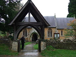
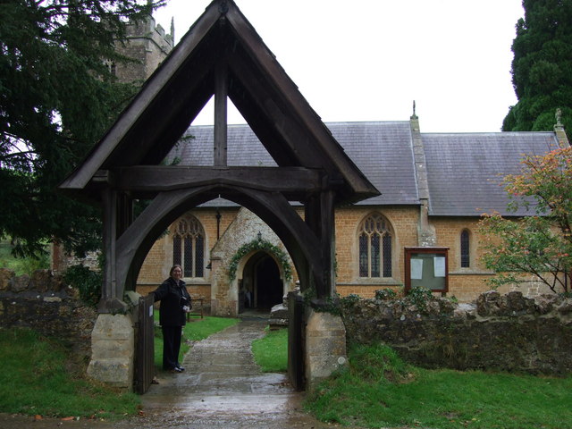
St Leonards Church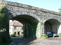
Railway Viaduct
 Pitcombe
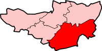
Pitcombe shown within SomersetPopulation 549 [1] OS grid reference ST675335 District South Somerset Shire county Somerset Region South West Country England Sovereign state United Kingdom Postcode district BA10 Police Avon and Somerset Fire Devon and Somerset Ambulance South Western EU Parliament South West England List of places: UK • England • Somerset Pitcombe is a village and civil parish 1 mile (2 km) south-west of Bruton and 5 miles (8 km) from Wincanton in Somerset, England. It has a population of 549.[1] The parish includes the hamlets of Cole and Godminster.
The village lies on the River Pitt and other streams which flow into the River Brue.
Godminster Lane Quarry and Railway Cutting is a geological Site of Special Scientific Interest which is important for study of the Inferior Oolite limestones, of Middle Jurassic age. The rocks do contain the rich assemblage of fossil ammonites which are typical of the north Dorset/south Somerset area. It is also important as a reference site for three sub-divisions (zones) of the Inferior Oolite — the laeviscula, discites and concavum Zones.[2]
Contents
History
The name Pitcombe means the marshy valley.[3]
Evidence of prehistoric activity has been found near Godminster Farm, where a Roman coin hoard was also discovered.[4]
In the Domesday Book of 1086 the manor was held by Turstin FitzRolf and already had two watermills.[3]
Pitcombe was part of the hundred of Bruton.[5]
It was on the Somerset and Dorset Joint Railway, which is now disused.
Governance
The parish council has responsibility for local issues, including setting an annual precept (local rate) to cover the council’s operating costs and producing annual accounts for public scrutiny. The parish council evaluates local planning applications and works with the local police, district council officers, and neighbourhood watch groups on matters of crime, security, and traffic. The parish council's role also includes initiating projects for the maintenance and repair of parish facilities, as well as consulting with the district council on the maintenance, repair, and improvement of highways, drainage, footpaths, public transport, and street cleaning. Conservation matters (including trees and listed buildings) and environmental issues are also the responsibility of the council.
The village falls within the Non-metropolitan district of South Somerset, which was formed on 1 April 1974 under the Local Government Act 1972, having previously been part of Wincanton Rural District.[6] The district council is responsible for local planning and building control, local roads, council housing, environmental health, markets and fairs, refuse collection and recycling, cemeteries and crematoria, leisure services, parks, and tourism.
Somerset County Council is responsible for running the largest and most expensive local services such as education, social services, libraries, main roads, public transport, policing and fire services, trading standards, waste disposal and strategic planning.
It is also part of a county constituency represented in the House of Commons of the Parliament of the United Kingdom. It elects one Member of Parliament (MP) by the first past the post system of election, and part of the South West England constituency of the European Parliament which elects seven MEPs using the d'Hondt method of party-list proportional representation.
Landmarks
Hadspen house and garden is within the parish. The house was built for William Player in the late 17th century, but has undergone several major restorations. It is built of Cary stone ashlar, with a hipped Welsh slate roof behind parapets and stone chimney stacks. It has been designated by English Heritage as a grade II* listed building.[7]
There is still a working quarry within the parish of pitcombe, notably Hadspen Quarry Ltd located in Higher Hadspen. They provide the stone to the locality which gives this area in South Somerset its local unique characteristics of honey coloured buildings.
Gants Mill is an 18th-century watermill with 13th-century origins. It is a Grade II* listed building[8] and now has a turbine producing hydroelectricity.
Godminster Manor is a 15th century manor house which underwent extensive restoration following a fire in 1924.[9]
Cole Manor dates from the 17th century.[10]
The dismantled Somerset and Dorset Joint Railway passes through the village over a viaduct. At the north of the village is the old Cole Railway Station.
The village is the home of Bruton School for Girls.
Religious sites
The church, dedicated to St Leonard, has a 15th-century tower at the west end containing three bells. The church was rebuilt, with the exception of its tower, in 1858. It has been designated by English Heritage as a Grade II listed building.[11]
Notable residents
- Herbert John "Bert" Pitman MBE (1877 – 1961) was the Third Officer on board the Titanic.
References
- ^ a b "South Somerset population estimates for 2002". Somerset County Council. http://www.webcitation.org/5lRyCVNCk. Retrieved 27 December 2009.
- ^ English Nature citation sheet for the site (accessed 10 August 2006)
- ^ a b Bush, Robin (1994). Somerset: The Complete Guide. Dovecote Press. pp. 168. ISBN 1874336261.
- ^ "Pitcombe". British History Online. http://www.british-history.ac.uk/report.aspx?compid=18735. Retrieved 24 November 2007.
- ^ "Bruton Hundred". A History of Britain. http://www.british-history.ac.uk/report.aspx?compid=18728. Retrieved 23 September 2011.
- ^ A Vision of Britain Through Time : Wincanton Rural District
- ^ "Hadspen House". Images of England. http://www.imagesofengland.org.uk/details/default.aspx?id=434632. Retrieved 24 November 2007.
- ^ "Gants Mill". Images of England. English Heritage. http://www.imagesofengland.org.uk/Details/Default.aspx?id=434673. Retrieved 31 October 2008.
- ^ "Godminster Manor". Images of England. English Heritage. http://www.imagesofengland.org.uk/Details/Default.aspx?id=434626. Retrieved 3 January 2009.
- ^ "Cole Manor". Images of England. English Heritage. http://www.imagesofengland.org.uk/Details/Default.aspx?id=434622. Retrieved 3 January 2009.
- ^ "Church of St Leonard". Images of England. http://www.imagesofengland.org.uk/Details/Default.aspx?id=434661. Retrieved 24 November 2007.
External links
Categories:- Villages in South Somerset
- Civil parishes in Somerset


Wikimedia Foundation. 2010.