- Drayton, Somerset
-
Coordinates: 51°01′10″N 2°51′04″W / 51.01947°N 2.85108°W
Drayton 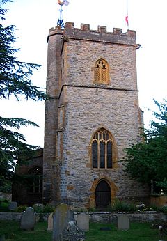
The tower of St Catherine's, Drayton
 Drayton
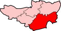
Drayton shown within SomersetPopulation 391 [1] OS grid reference ST404248 District South Somerset Shire county Somerset Region South West Country England Sovereign state United Kingdom Dialling code 01458 Police Avon and Somerset Fire Devon and Somerset Ambulance South Western EU Parliament South West England UK Parliament Somerton and Frome List of places: UK • England • Somerset Drayton is a village and civil parish in Somerset, England, situated less than a mile from Curry Rivel and five miles southwest of Somerton in the South Somerset district. It is situated on the River Isle, near its confluence with the Parrett, and the former Westport Canal. The parish includes the hamlet of Midelney.
The village has a population of 391[1] and is home to St Catherine's parish church and the Drayton Arms pub.
Contents
History
It is believed the name of the village means "the settlement near a slope for dragging loads" or "where ledges or drays were used".[2]
Drayton was part of the hundred of Abdick and Bulstone.[3][4]
Governance
The parish council has responsibility for local issues, including setting an annual precept (local rate) to cover the council’s operating costs and producing annual accounts for public scrutiny. The parish council evaluates local planning applications and works with the local police, district council officers, and neighbourhood watch groups on matters of crime, security, and traffic. The parish council's role also includes initiating projects for the maintenance and repair of parish facilities, as well as consulting with the district council on the maintenance, repair, and improvement of highways, drainage, footpaths, public transport, and street cleaning. Conservation matters (including trees and listed buildings) and environmental issues are also the responsibility of the council.
The village falls within the Non-metropolitan district of South Somerset, which was formed on 1 April 1974 under the Local Government Act 1972, having previously been part of Langport Rural District.[5] The district council is responsible for local planning and building control, local roads, council housing, environmental health, markets and fairs, refuse collection and recycling, cemeteries and crematoria, leisure services, parks, and tourism.
Somerset County Council is responsible for running the largest and most expensive local services such as education, social services, libraries, main roads, public transport, policing and fire services, trading standards, waste disposal and strategic planning.
It is also part of the Somerton and Frome county constituency represented in the House of Commons of the Parliament of the United Kingdom. It elects one Member of Parliament (MP) by the first past the post system of election, and part of the South West England constituency of the European Parliament which elects seven MEPs using the d'Hondt method of party-list proportional representation.
Landmarks
Midelney Manor is a Grade I manor house in landscaped grounds. It is sited on a former island site, and was the property of Muchelney Abbey, passing to the Trevillian family after the dissolution of the monasteries. The present house was built in the late 16th century in two distinct halves by Richard and Thomas Trevillian.[6] Drayton Manor is more recent and was built in the late 18th or early 19th century.[7]
Religious sites
St Catherine's exterior is blue lias and golden hamstone. It dates from the 15th century, being restored in 1855 by Maurice Davis of Langport and again in 1896. It has been designated by English Heritage as a Grade I listed building.[8] The 15th-century cross in the churchyard has a sculpture of St Michael with a sword and shield in the act of vanquishing a dragon.[9] The rectory, known as Drayton Court, which dates from the early 19th century, is now a private house.[10]
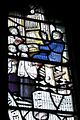
Stained Glass Windows at St Catherine's, Drayton
-
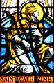
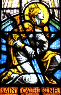
Window showing the namesake saint, Catherine of Alexandria
-

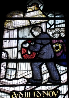
Window depicting the laying of a poppy wreath, honouring soldiers who died in the World Wars
-
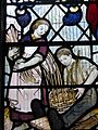
Window depicting basketweaving, a local cottage industry
-
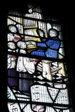
Window depicting the church organist and children's choir
References
- ^ a b "South Somerset population estimates for 2002". Somerset County Council. http://www.webcitation.org/5lRyCVNCk. Retrieved 27 December 2009.
- ^ Bush, Robin (1994). Somerset: The complete guide. Wimborne, Dorset: Dovecote Press. ISBN 187433627X.
- ^ "Abdick and Bulstone Hundred Through Time". A Vision of Britain Through Time. http://www.visionofbritain.org.uk/relationships.jsp?u_id=10133830. Retrieved 9 September 2011.
- ^ "Abdick and Bulstone in South Somerset". A Vision Britain Through Time. http://www.visionofbritain.org.uk/place/place_page.jsp?p_id=21175. Retrieved 9 September 2011.
- ^ A Vision of Britain Through Time : Langport Rural District
- ^ "Midelney Manor, forecourt and garden walling with gate-piers". Images of England. http://www.imagesofengland.org.uk/details/default.aspx?id=264359. Retrieved 28 September 2007.
- ^ "Drayton Manor". Images of England. http://www.imagesofengland.org.uk/details/default.aspx?id=264364. Retrieved 28 September 2007.
- ^ "Church of St. Catherine". Images of England. http://www.imagesofengland.org.uk/details/default.aspx?id=264336. Retrieved 26 September 2007.
- ^ "Cross in churchyard of Church of St Catherine". Images of England. http://www.imagesofengland.org.uk/details/default.aspx?id=264340. Retrieved 28 September 2007.
- ^ "Drayton Court". Images of England. http://www.imagesofengland.org.uk/details/default.aspx?id=264342. Retrieved 28 September 2007.
External links
 Media related to Drayton, Somerset at Wikimedia CommonsCategories:
- Villages in South Somerset
- Civil parishes in Somerset
-


Wikimedia Foundation. 2010.