- Merriott
-
Coordinates: 50°54′33″N 2°47′27″W / 50.9092°N 2.7907°W
Merriott 
All Saints Church, Merriott
 Merriott
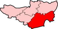
Merriott shown within SomersetPopulation 2,020 [1] OS grid reference ST445125 District South Somerset Shire county Somerset Region South West Country England Sovereign state United Kingdom Post town MERRIOTT Postcode district TA16 Dialling code 01460 Police Avon and Somerset Fire Devon and Somerset Ambulance South Western EU Parliament South West England UK Parliament Yeovil List of places: UK • England • Somerset Merriott is a village and civil parish in Somerset, England, near the town of Crewkerne and 7 miles (11.3 km) west of Yeovil in the South Somerset district. The village has a population of 2,020.[1]
On Church Street, there is a well-preserved tithe barn, which is used by local organisations including the playgroup, badminton club and a Morris dancing side (Dr Turberville's Morris). The village is home to Merriott Rovers FC. Also situated in Merriott is a Co-op and all-purpose food store. It has two pubs: the 17th century King's Head[2] and the 19th century Swan.[3]
The parish boundary includes the River Parrett which is crossed by the Bow Bridge.[4] Next to it is Bow Mill House, with its attached watermill which dates from the 17th century.[5] Tail Mill was used for sail cloth manufacture.[6]
Contents
History
The name Merriott means boundary gate.[7]
The manor was held at the time of the Domesday Book in 1086 by Harding son of Eadnorth whose descendants took the name of the village and continued until the death of Sir John de Meriet in 1391. The good quality of the soil led to the development of market-gardening, with the first use in England of the word nursery (noresire) occurred at Merriot in 1369.[7]
The parish was part of the hundred of Crewkerne.[8]
Major rebuilding took place in the village following a fire in 1811.[9]
The school building dates from 1876,[10] and now incorporates the former Sunday school which was built in 1834.[11]
Governance
The parish council has responsibility for local issues, including setting an annual precept (local rate) to cover the council’s operating costs and producing annual accounts for public scrutiny. The parish council evaluates local planning applications and works with the local police, district council officers, and neighbourhood watch groups on matters of crime, security, and traffic. The parish council's role also includes initiating projects for the maintenance and repair of parish facilities, as well as consulting with the district council on the maintenance, repair, and improvement of highways, drainage, footpaths, public transport, and street cleaning. Conservation matters (including trees and listed buildings) and environmental issues are also the responsibility of the council.
The village falls within the Non-metropolitan district of South Somerset, which was formed on 1 April 1974 under the Local Government Act 1972, having previously been part of Chard Rural District.[12] The district council is responsible for local planning and building control, local roads, council housing, environmental health, markets and fairs, refuse collection and recycling, cemeteries and crematoria, leisure services, parks, and tourism.
Somerset County Council is responsible for running the largest and most expensive local services such as education, social services, libraries, main roads, public transport, policing and fire services, trading standards, waste disposal and strategic planning.
It is also part of the Yeovil county constituency represented in the House of Commons of the Parliament of the United Kingdom. It elects one Member of Parliament (MP) by the first past the post system of election, and part of the South West England constituency of the European Parliament which elects seven MEPs using the d'Hondt method of party-list proportional representation.
Religious sites
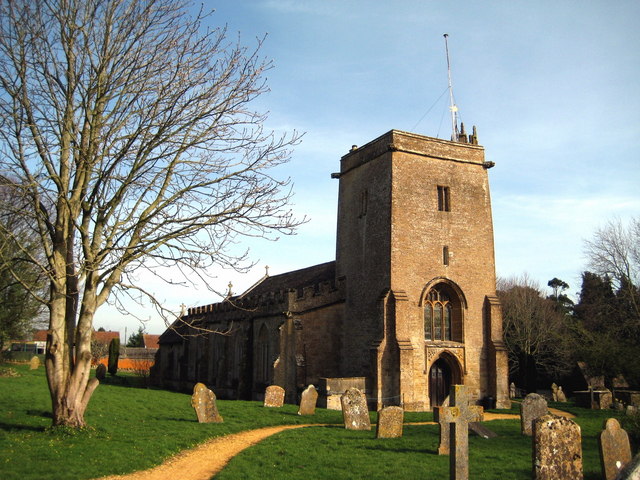
The Anglican parish Church of All Saints dates from the 13th century, with modifications in the late 15th or early 16th century, and major restoration including the extension of the nave, a new chancel and chapels by Benjamin Ferrey in 1860. It has been designated as a Grade II* listed building.[13]
References
- ^ a b "South Somerset population estimates for 2002". Somerset County Council. http://www.webcitation.org/5lRyCVNCk. Retrieved 27 December 2009.
- ^ "King's Head Inn". Images of England. English Heritage. http://www.imagesofengland.org.uk/Details/Default.aspx?id=262356. Retrieved 26 January 2009.
- ^ "The Swan Inn". Images of England. English Heritage. http://www.imagesofengland.org.uk/Details/Default.aspx?id=262388. Retrieved 26 January 2009.
- ^ "Bow Bridge". Images of England. English Heritage. http://www.imagesofengland.org.uk/Details/Default.aspx?id=262341. Retrieved 26 January 2009.
- ^ "Bow Mill House, with attached mill". Images of England. English Heritage. http://www.imagesofengland.org.uk/Details/Default.aspx?id=262342. Retrieved 26 January 2009.
- ^ "Tail Mill". Images of England. English Heritage. http://www.imagesofengland.org.uk/Details/Default.aspx?id=479684. Retrieved 26 January 2009.
- ^ a b Bush, Robin (1994). Somerset: The complete guide. Wimborne: The Dovecote Press Ltd. pp. 142. ISBN 1874336261.
- ^ "Somerset Hundreds". GENUKI. http://www.genuki.org.uk/big/eng/SOM/Miscellaneous/. Retrieved 8 October 2011.
- ^ Havinden, Michael (1982). The Somerset Landscape. The making of the English landscape. London: Hodder and Stoughton. p. 139. ISBN 0340201169.
- ^ "Merriott First School". Images of England. English Heritage. http://www.imagesofengland.org.uk/Details/Default.aspx?id=262371. Retrieved 26 January 2009.
- ^ "Former Sunday School". Images of England. English Heritage. http://www.imagesofengland.org.uk/Details/Default.aspx?id=262402. Retrieved 26 January 2009.
- ^ A Vision of Britain Through Time : Chard Rural District
- ^ "Church of All Saints". Images of England. English Heritage. http://www.imagesofengland.org.uk/Details/Default.aspx?id=262359. Retrieved 26 January 2009.
External links
 Media related to Merriott at Wikimedia CommonsCategories:
- Villages in South Somerset
- Civil parishes in Somerset

Wikimedia Foundation. 2010.