- Donyatt
-
Coordinates: 50°55′34″N 2°56′51″W / 50.9261°N 2.9475°W
Donyatt 
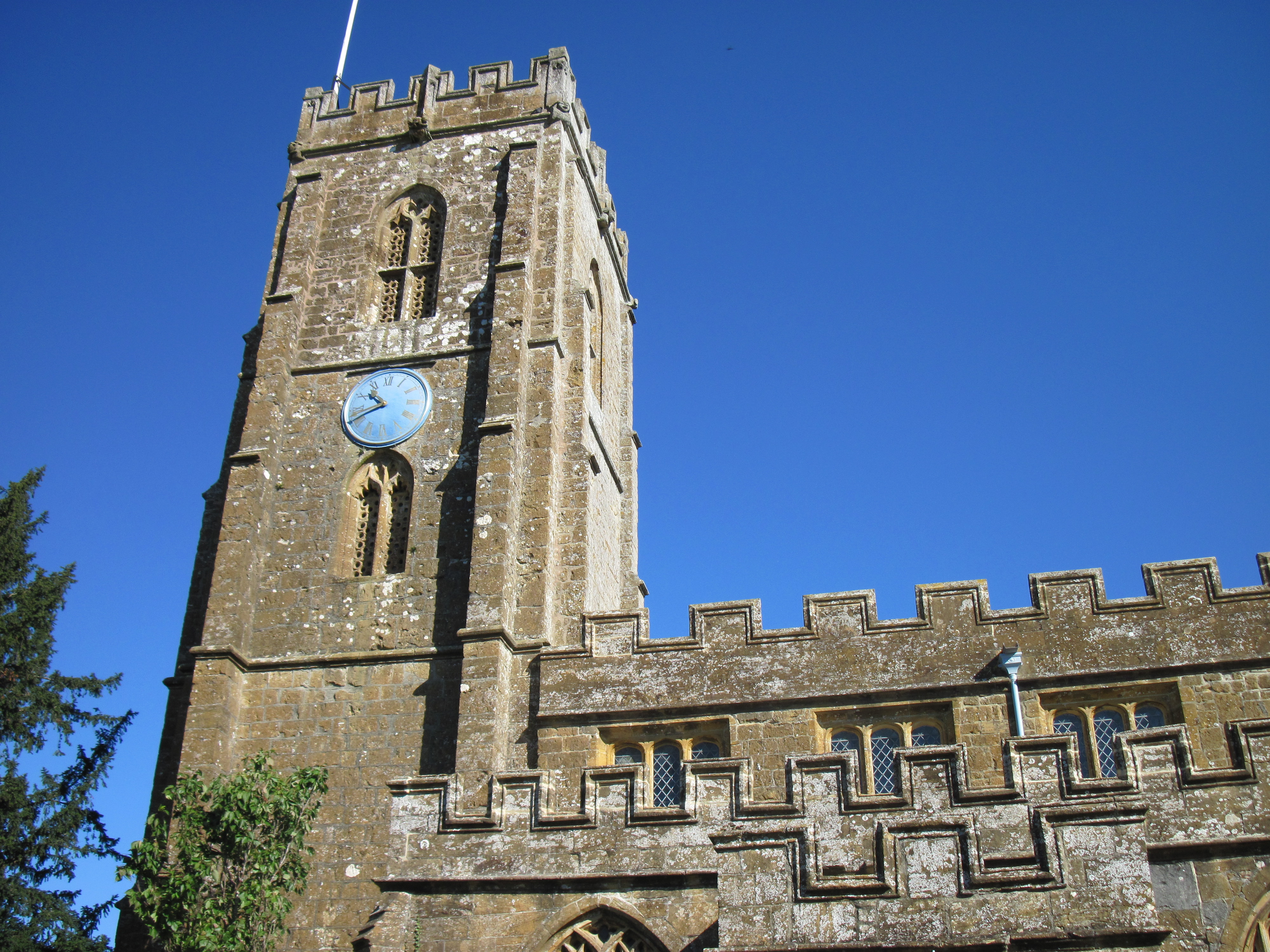
The Blessed Virgin Mary Church, Donyatt
 Donyatt
Donyatt shown within SomersetPopulation 368 [1] OS grid reference ST335145 District South Somerset Shire county Somerset Region South West Country England Sovereign state United Kingdom Post town CHARD Postcode district TA19 Dialling code 01460 Police Avon and Somerset Fire Devon and Somerset Ambulance South Western EU Parliament South West England UK Parliament Yeovil List of places: UK • England • Somerset Donyatt is a village and civil parish in Somerset, England, situated at the source of the River Isle 5 miles (8.0 km) north of Chard in the South Somerset district. The village has a population of 368.[1]
Contents
History
The village was recorded as Dunnyete meaning Dunna's gate in 725.[2]
Donyatt was part of the hundred of Abdick and Bulstone.[3][4]
In 1328 it was the birthplace of William Montacute, 2nd Earl of Salisbury, whose family held the manor and built a castle or fortified manor house. It had a manorial chapel and it is from this that a Sheela na Gig was recovered and is now incoproated into a private house.[5]
The almshouses in Church Street date from 1624,[6] and were founded under the will of John Dunster of London (died 1625).[2] Next to them is the old school house, which was built in the early 19th century,[7] and the old school which dates from 1871.[8]
The Old clay puddling house, a circular thatched building, is a former pottery dating from the 18th century,[9] when there were also woollen-mills in the village. Thirty-three examples of pottery from Donyatt have been identified from five sites in Virginia and Maryland.[10]
The "Sea Bridge" carries the road over a stream. IT was built in the 18th century with three semi- circular arches.[11]
Donyatt has been listed by English Heritage as a Conservation Area at risk with a current condition status of Very Bad.[12]
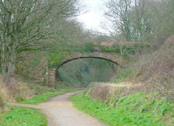
 The site of Donyatt Halt, between Chard and Ilminster on the B&ER branch line
Donyatt had a small halt along the Chard Branch Line just before Ilminster, which served the local community, it was constructed from sleepers laid horizontally and pegged together to form a basic platform structure, a small over canopy "shed" served as a shelter during the winter months, access to the platform was gained by crossing over the bridge and accessing an inclined path. The Halt is next to some World War II defences used on the Taunton Stop Line, with anti-tank traps around the station. During the threat of invasion, an inspection post could be quickly setup between Donyatt and Ilminster to stop and check the trains before proceeding on the down line "to" and "from" Chard. This was achieved by placing a barrier on some cut out stones entering the Donyatt Halt, you can see these if you wonder why there are two opposite stones on the cycle path, one will have a hole cut into it to act as a pivot for the barrier.
Governance
The parish council has responsibility for local issues, including setting an annual precept (local rate) to cover the council’s operating costs and producing annual accounts for public scrutiny. The parish council evaluates local planning applications and works with the local police, district council officers, and neighbourhood watch groups on matters of crime, security, and traffic. The parish council's role also includes initiating projects for the maintenance and repair of parish facilities, as well as consulting with the district council on the maintenance, repair, and improvement of highways, drainage, footpaths, public transport, and street cleaning. Conservation matters (including trees and listed buildings) and environmental issues are also the responsibility of the council.
The village falls within the Non-metropolitan district of South Somerset, which was formed on 1 April 1974 under the Local Government Act 1972, having previously been part of Chard Rural District.[13] The district council is responsible for local planning and building control, local roads, council housing, environmental health, markets and fairs, refuse collection and recycling, cemeteries and crematoria, leisure services, parks, and tourism.
Somerset County Council is responsible for running the largest and most expensive local services such as education, social services, libraries, main roads, public transport, policing and fire services, trading standards, waste disposal and strategic planning.
It is also part of the Yeovil county constituency represented in the House of Commons of the Parliament of the United Kingdom. It elects one Member of Parliament (MP) by the first past the post system of election, and part of the South West England constituency of the European Parliament which elects seven MEPs using the d'Hondt method of party-list proportional representation.
Religious sites
The Anglican parish Church of St Mary is a 15th rebuild of earlier church, where the first recorded rector was in 1255. It has been designated as a grade II* listed building.[14]
References
- ^ a b "South Somerset population estimates for 2002". Somerset County Council. http://www.webcitation.org/5lRyCVNCk. Retrieved 27 December 2009.
- ^ a b Bush, Robin (1994). Somerset: The Complete Guide. Dovecote Press. pp. 84. ISBN 1874336261.
- ^ "Abdick and Bulstone Hundred Through Time". A Vision of Britain Through Time. http://www.visionofbritain.org.uk/relationships.jsp?u_id=10133830. Retrieved 9 September 2011.
- ^ "Abdick and Bulstone in South Somerset". A Vision Britain Through Time. http://www.visionofbritain.org.uk/place/place_page.jsp?p_id=21175. Retrieved 9 September 2011.
- ^ "The Donyatt Figure". The Sheela Na Gig Project. http://www.sheelanagig.org/index.html#http://www.sheelanagig.org/SheelaDonyatt.htm. Retrieved 4 January 2009.
- ^ "The Almshouses". Images of England. English Heritage. http://www.imagesofengland.org.uk/Details/Default.aspx?id=263922. Retrieved 4 January 2009.
- ^ "School House". Images of England. English Heritage. http://www.imagesofengland.org.uk/Details/Default.aspx?id=263931. Retrieved 4 January 2009.
- ^ "The Old School,". Images of England. English Heritage. http://www.imagesofengland.org.uk/Details/Default.aspx?id=263932. Retrieved 4 January 2009.
- ^ "Old clay puddling house". Images of England. English Heritage. http://www.imagesofengland.org.uk/Details/Default.aspx?id=263942. Retrieved 4 January 2009.
- ^ Coleman-Smith, Richard; Kiser, R. Taft; Hughes, Michael J. (Sept 2005). "Donyatt-type pottery in 17th- and 18th-century Virginia and Maryland". Post-Medieval Archaeology 39 (2): 294–310. doi:10.1179/007943205X62679. http://www.ingentaconnect.com/content/maney/pma/2005/00000039/00000002/art00008;jsessionid=10kua6ti2d8ot.alexandra. Retrieved 4 January 2009.
- ^ "Sea Bridge, about 160 metres north west of Sea Mill Farmhouse". Images of England. English Heritage. http://www.imagesofengland.org.uk/Details/Default.aspx?id=263941. Retrieved 4 January 2009.
- ^ "Donyatt". Conservation Areas at Risk. English Heritage. http://risk.english-heritage.org.uk/2010.aspx?id=9421&rt=0&pn=2&st=a&di=South+Somerset&ctype=all&crit=. Retrieved 19 December 2010.
- ^ A Vision of Britain Through Time : Chard Rural District
- ^ "Church of St Mary". Images of England. English Heritage. http://www.imagesofengland.org.uk/Details/Default.aspx?id=263923. Retrieved 4 January 2009.
External links
Categories:- Villages in South Somerset
- Civil parishes in Somerset

Wikimedia Foundation. 2010.