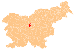
- Domžale
-
Domžale — City and Municipality — Franc Bernik's Culture Centre in Domžale Location of the Municipality of Domžale in Slovenia Location of the Town of Domžale in Slovenia Coordinates: 46°08′N 14°36′E / 46.133°N 14.6°ECoordinates: 46°08′N 14°36′E / 46.133°N 14.6°E Country  Slovenia
Government - Mayor Toni Dragar Area - Total 72.3 km2 (27.9 sq mi) Population (2002)[1] - Total 32,205 - Density 445.4/km2 (1,153.7/sq mi) Time zone CET (UTC+01) - Summer (DST) CEST (UTC+02) Area code(s) 01 Website Official website Domžale (
 pronunciation (help·info)) is a municipality and city Slovenia. Domžale is known today for its flourishing small businesses, agriculture, and light industry (Količevo Paper Mill, Tosama, Helios). It is the site of the renaissance Krumperk Castle. It has a lively traditional music scene.
The municipality lies near the foothills of the Kamnik Alps and is crossed by the river Kamniška Bistrica that originates in these Alps. Its landscape is characterized by forested hills and agricultural plains.
The Domžale radio transmitter, the most powerful transmitter in Slovenia, is located near the town of Domžale. It operates on medium wave frequency 918 kHz that can be received at night throughout Europe. As an aerial it uses a 161 metre high guyed steel tube mast.
Contents
Boroughs (Municipality of Domžale)
- Dob
- Jarše-Rodica
- Krtina
- Preserje pri Radomljah
- Radomlje
- Rova
- Homec-Nožice
- Dragomelj-Pšata
- Prelog
- Ihan
- Toma Brejca Vir
- Slavka Šlandra (Downtown)
- Simona Jenka (Študa)
- Venclja Perka (Stob)
Districts (Municipalities)
Sports
History
The remains of an ice-age hunter's dwelling found at Babja jama in Gorjuša date to 15,000 BP. There is archaeological evidence of a pre-Roman Illyrian and Celtic settlement. Roman finds date to the time of the road connecting Aquileia, Æmona (today Ljubljana, and Celeia (today Celje). The area is first mentioned in documents datint to the 12th century. A local nobleman and owner of Krumperk Castle, Adam Ravbar, was a victor in the Battle of Sisak in 1593, in which the Ottoman army was defeated.
Economic development accelerated in the 19th century with the industrialization of the local craft of straw weaving (Slovene: slamnikarstvo).
References
- Bernik, Franc. Zgodovina fare Domžale, 2 vols. Kamnik, 1923; Groblje, 1939.
- Klobčar, Marjana. Občina Domžale (Etnološka topografija slovenskega etničnega ozemlja - 20. stoletje). Ljubljana: Znanstveni inštitut Filozofske fakultete, 1989.
External links
- Domžale at Geopedia
- Official page of municipality (Slovene)
- Domžale, Randburg Co. page (English)
- Boštjan Burger's cultural heritage website, Panoramic view of Domžale
- Domžalski komorni zbor (Chamber Choir of Domžale) (Slovene)
Domžale Settlements Administrative centre: Domžale
Bišče, Brdo, Brezje pri Dobu, Brezovica pri Dobu, Češenik, Depala vas, Dob, Dobovlje, Dolenje, Dragomelj, Goričica pri Ihanu, Gorjuša, Homec, Hudo, Ihan, Jasen, Kokošnje, Količevo, Kolovec , Krtina, Laze pri Domžalah, Mala Loka, Nožice, Podrečje, Prelog, Preserje pri Radomljah, Pšata, Rača, Račni Vrh, Radomlje, Rodica, Rova, Selo pri Ihanu, Spodnje Jarše, Srednje Jarše, Studenec pri Krtini, Sveta Trojica, Šentpavel pri Domžalah, Škocjan, Škrjančevo, Turnše, Vir, Zaboršt, Zagorica pri Rovah, Zalog pod Sveto Trojico, Zgornje Jarše, Žeje, Želodnik, ŽičeLandmarks Železna Cave, Krumperk Castle, Saint Kunigunda on Tabor, Groblje Parish ChurchCategories:- Populated places in the Municipality of Domžale
- Municipalities of Slovenia
- Archaeology of Illyria
Wikimedia Foundation. 2010.


